U9 (Berlin U-Bahn)

Last updated

Berlin transit icons - U9.svg
Hansaplatz-ubahn.jpg
Hansaplatz, one of the stations of the U9
Overview
Locale Berlin
Termini
Stations18
Service
Type Rapid transit
System Berlin U-Bahn
Operator(s) Berliner Verkehrsbetriebe
Depot(s)
  • Britz
Rolling stock
History
Opened28 August 1961 (1961-08-28) [lower-alpha 1]
Last extension30 April 1976 (1976-04-30) [lower-alpha 2]
Technical
Line length12.5 km (7.8 mi) [2]
Track gauge 1,435 mm (4 ft 8+12 in) standard gauge
Loading gauge Großprofil
Electrification 750 V DC third rail (bottom running)
Route map

Contents

BSicon tENDEa grey.svg
105.7
Reversing point
BSicon tKINTACCa carrot.svg
BSicon tKSTRe grey.svg
105.3
Osloer Straße
Berlin transit icons - U8.svg MetroTram.svg
BSicon tHSTACC carrot.svg
104.5
Nauener Platz
BSicon tINTACC carrot.svg
103.7
Leopoldplatz
Berlin transit icons - U6.svg
BSicon tHSTACC carrot.svg
102.9
Amrumer Straße
BSicon tKRZW carrot.svg
BSicon tINTACC carrot.svg
102.1
Westhafen
S-Bahn-Logo.svg
BSicon tHSTACC carrot.svg
101.6
Birkenstraße
BSicon tHSTACC carrot.svg
100.9
Turmstraße
MetroTram.svg
BSicon tKRZW carrot.svg
BSicon tHSTACC carrot.svg
100.0
Hansaplatz
BSicon tKRZW carrot.svg
BSicon tINTACC carrot.svg
98.6
Zoologischer Garten
Berlin transit icons - U2.svg S-Bahn-Logo.svg VBB Bahn-Regionalverkehr.svg
BSicon tINTACC carrot.svg
98.1
Kurfürstendamm
Berlin transit icons - U1.svg
BSicon tINTACC carrot.svg
97.5
Spichernstraße
Berlin transit icons - U3.svg
BSicon tHST carrot.svg
96.9
Güntzelstraße
BSicon tINTACC carrot.svg
96.4
Berliner Straße
Berlin transit icons - U7.svg
BSicon tINTACC carrot.svg
95.3
Bundesplatz
S-Bahn-Logo.svg
BSicon tHSTACC carrot.svg
94.6
Friedrich-Wilhelm-Platz
BSicon tHSTACC carrot.svg
94.0
Walther-Schreiber-Platz
BSicon tHST carrot.svg
93.3
Schloßstraße
BSicon tKINTACCe carrot.svg
BSicon tKSTRa grey.svg
92.7
Rathaus Steglitz
S-Bahn-Logo.svg
BSicon tENDEe grey.svg
92.3
Reversing point

U9 is a line on the Berlin U-Bahn. The line was opened on 28 August 1961 as Line G.

Route

The path of the U9 is completely underground. It starts in the north at Osloer Straße in Gesundbrunnen and runs through Wedding before passing under the Berlin Ringbahn and running through Moabit, reaching Hansaplatz and Tiergarten before crossing the Berlin Stadtbahn at the Zoo and Kurfürstendamm, eventually leaving western central Berlin by heading to Friedenau and finally Steglitz at Rathaus Steglitz.

History

First stage of construction

After the division of Berlin in 1948, the citizens of West Berlin preferred buses and trams that bypassed East Berlin. Furthermore, the highly populated boroughs of Steglitz, Wedding and Reinickendorf were in need of rapid transit access to the new center of West Berlin south of the Zoo. This prompted the construction of a completely new line, then called line G, becoming the third north–south line after line C (modern U6) and line D (modern U8).

Groundbreaking took place on 23 June 1955 at Tiergarten. Construction was difficult as it needed to pass under four U-Bahn lines (U1, U2, U3, U6), two S-Bahn lines (Stadtbahn, Ringbahn twice) and three waterways (Spree River, Landwehr Canal, Berlin-Spandau Canal).

Line G from Leopoldplatz to Spichernstraße was planned to open on 2 September 1961. This was pushed up to 28 August 1961 after the construction of the Berlin Wall underscored the necessity of this new line. To accommodate the U9, the Nürnberger Platz station was closed. It was replaced by Spichernstraße (opened 2 June 1959) and Augsburger Straße (opened 8 May 1961) stations respectively.

The new stations include:

It will also interchange with the smaller profile station, but it was opened on the same day as U9 was opened:

Second stage

Since the subsidies from the Federal Republic still went to West Berlin, was further built on the busy subway. On 29 January 1971, the longest subway extensions was implemented. The U7 takes the lead of the Möckernbrücke to Fehrbelliner Platz, Line 9 of the Spichernstraße to Walther-Schreiber-Platz. Nine kilometers of track with eleven new stations went into operation on that day. Groundbreaking began 1 July 1962. For the Steglitz and Neukölln a fast connection to the western center and no longer had the buses in claim take.

The route follows the U9 from the previous terminus Spichernstraße the Bundesallee and crosses line U7 on Berliner Straße. The lower platform is a central platform, the U9 has here. This however is not in the usual sense: On one side of the platform, climb—at the station Berliner Straße usually on the right side, but on the left side—seen in the direction of travel. It could also be seen as apart Laid central platforms the platforms thus. Only one transition at the north end of both platforms interconnects. This construction project was necessary because the subway construction, a road tunnel between the two side platforms was built.

Similar to the Berliner Straße railway station also encloses the then-newly built Bundesplatz a road tunnel, which is why no central platform was also built here. The tracks split up shortly before the station to bypass the tunnel and there were two side platforms.

All stations were built designed by Rainer G. Rümmler. Here, instead of the current ceramic tiles, large-format colorful fiber cement plates are used, such as the station Walther-Schreiber-Platz. Even should associations by the color scheme is always new are awakened. From Bahnhof Berliner Straße, the colors are white and red on the Coat of arms of Berlin remember, at the station Eisenacher Straße U7 the green faces on the Thuringian Forest at Eisenach. Another reason why the architect is very controversial.

Final extension

Between Walther-Schreiber-Platz station and the Schloßstraße the U9 changes to the tunnel section of U10. In Schloßstraße station itself, the tracks are heading north on the top, in the direction of Rathaus Steglitz on the lower level, however, the offices on the eastern edge of the platform on which was supposed to take the U10. The western edge of the platform is separated by a fence from the passenger traffic. In track trough, unused tracks are laid without power rail. To date, there hangs the sign "No trains". By these enormous constructed provisions, the cost of one meter underground route exorbitantly to 78,000 Mark (adjusted for purchasing power in today's money).

Behind the Schloßstraße ends the U9 at the Rathaus Steglitz. The paths of U9 and U10 here separate again. Both lines should keep in Steglitz at separate stations, viewed from Schloßstraße from an end opening "V" would form. The intended actually for the U9 station Part (Rzo) is equipped with side platforms, located in the minus-1 level until now has been completed only in the shell and is cut off as a storeroom for the civil protection used. The original platform is operated for the U9 instead of planned for the U10 Station part (Rzu) in the minus-2 level.

The background for this management decision lies at the intersection of the planned U9-line and Wannseebahn immediately south of the station. In the 1970s, negotiations with the Deutsche Reichsbahn regarding the railway line to Steglitz station proved unsuccessful. Consequently, the BVG did not create the necessary sweeping system behind the station. Unlike the west-extending U10, the U9 faced challenges, leading it to be routed along the U10 with a reversing facility. In January 1984, when the operation shifted to BVG, an opportunity arose to pass under the S-Bahn without reopening negotiations with the Reichsbahn. With this assurance, the functionless tunnel was extended beneath the railway embankment in the mid-1980s. However, a reversing facility, or at least a part of it, was not incorporated into this section, with plans to address this in a subsequent part of the tunnel.

The section to Rathaus Stegliz was definitely opened on 30 September 1974, its construction began on 7 July 1969.

The addition is from Leopoldplatz to Osloer Straße. It was opened on 30 April 1976, construction began on 6 November 1969. Since this was not feasible but due to the political situation, they let the U9 only to cross Osloer Straße/Swedener Straße construct. They were provided for two new stations: Nauener Platz, Turmstraße, and Osloer Straße. Until then, the U8 can be extended. This resulted in the situation that this tower station could be built without regard to existing underground services. It has also helped build a spacious, bright basement distribution, in which there are several shops and snack bars.

Planned extensions

The route was suggested to go via Holzstraße, Wollankstraße and will be divided into two options:

All planned extensions were abandoned due to low patronage.

Notes

  1. From Leopoldplatz to Spichernstraße
  2. From Leopoldplatz to Osloer Straße

Related Research Articles

<span class="mw-page-title-main">Berlin U-Bahn</span> Rapid transport system of Berlin, Germany

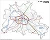
The Berlin U-Bahn is a rapid transit system in Berlin, the capital and largest city of Germany, and a major part of the city's public transport system. Together with the S-Bahn, a network of suburban train lines, and a tram network that operates mostly in the eastern parts of the city, it serves as the main means of transport in the capital.

<span class="mw-page-title-main">Berlin S-Bahn</span> Rapid transit railway system in and around Berlin

The Berlin S-Bahn is a rapid transit railway system in and around Berlin, the capital city of Germany. It has been in operation under this name since December 1930, having been previously called the special tariff area Berliner Stadt-, Ring- und Vorortbahnen. It complements the Berlin U-Bahn and is the link to many outer-Berlin areas, such as Berlin Brandenburg Airport. As such, the Berlin S-Bahn blends elements of a commuter rail service and a rapid transit system.

<span class="mw-page-title-main">U1 (Berlin U-Bahn)</span> Rapid transit line in Berlin, Germany

U1 is a line on the Berlin U-Bahn, which is 8.8 kilometres (5.5 mi) long and has 13 stations. Its traditional line designation was BII. It runs east–west and its eastern terminus is Warschauer Straße S-Bahn station where it connects to the Schlesische Bahn. From there it runs through Kreuzberg via Gleisdreieck and Wittenbergplatz on to the Kurfürstendamm.

<span class="mw-page-title-main">U2 (Berlin U-Bahn)</span> Underground line in Berlin

U2 is a line of the Berlin U-Bahn. The U2 line starts at Pankow S-Bahn station, runs through the eastern city centre (Alexanderplatz) to Potsdamer Platz, the western city centre and finally to the Ruhleben terminal station.

<span class="mw-page-title-main">U5 (Berlin U-Bahn)</span>

U5 is a line on the Berlin U-Bahn. It runs from Hauptbahnhof in Mitte eastwards through Alexanderplatz, Friedrichshain, Lichtenberg and Friedrichsfelde, surfaces in Biesdorf-Süd to pass Kaulsdorf and Hellersdorf above ground and finally reaches city limits at Hönow.

<span class="mw-page-title-main">U6 (Berlin U-Bahn)</span>

U6 is a 19.9 km (12.4 mi) long rapid transit line on the Berlin U-Bahn with 29 stations. It runs in a north-south direction from the Berlin locality of Tegel in the north via Friedrichstraße to Mariendorf, a locality in the southern part of the city. It is one of the five large profile ("Großprofil") lines.

<span class="mw-page-title-main">U7 (Berlin U-Bahn)</span> Rail line on the Berlin U-Bahn

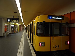
The U7 is a rail line on the Berlin U-Bahn. It runs completely underground for a length of 31.8 kilometres (19.8 mi) through 40 stations and connects Spandau, via Neukölln, to Gropiusstadt and Rudow. The U7 was originally the south-eastern branch of the Nord-Süd-Bahn (U6) that ran between the branching point at Belle-Alliance-Straße (Mehringdamm) and Grenzallee; however, in the 1960s, this stretch was separated from the rest of the line and extended at each end to form a new line.

<span class="mw-page-title-main">U8 (Berlin U-Bahn)</span>

U8 is a line on the Berlin U-Bahn. It has 24 stations and is 18.1 km (11.2 mi) long. The U8 is one of three north–south Berlin U-Bahn lines, and runs from Wittenau to Neukölln via Gesundbrunnen. The original proposal was for a suspended monorail like the Wuppertal Schwebebahn.

<span class="mw-page-title-main">Berlin Jungfernheide station</span> Railway station in Berlin

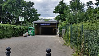
Berlin Jungfernheide is a railway station located at Charlottenburg-Nord, in the Charlottenburg-Wilmersdorf district of Berlin, served by the S-Bahn lines S41 and S42, the U-Bahn line U7 and Regional-Express trains of the Deutsche Bahn. Its name literally translates into "maidens' heathland"; it was named after the Jungfernheide, a former large forest in the proximity of this station.

<span class="mw-page-title-main">U3 (Berlin U-Bahn)</span>

U3 is a line on the Berlin U-Bahn created in its current version on 7 May 2018.

<span class="mw-page-title-main">Munich U-Bahn</span> Rapid transit railway in Munich, Germany

The Munich U-Bahn is an electric rail rapid transit network in Munich, Germany. The system began operation in 1971, and is operated by the municipally owned Münchner Verkehrsgesellschaft. The network is integrated into the Münchner Verkehrs- und Tarifverbund and interconnected with the Munich S-Bahn. The U-Bahn currently comprises eight lines, serving 96 stations, and encompassing 103.1 kilometres (64.1 mi) of routes.

S26 is a line on the Berlin S-Bahn. It runs from Teltow in the district (Kreis) of Potsdam-Mittelmark via Südkreuz, through the Berlin Nord-Süd Tunnel with a stop at Friedrichstraße, and ends in Waidmannslust in the borough of Reinickendorf. On weekends the S26 runs from Teltow to Potsdamer Platz.

<span class="mw-page-title-main">Spichernstraße (Berlin U-Bahn)</span> Station of the Berlin U-Bahn

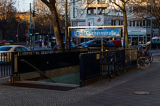
Spichernstraße is a Berlin U-Bahn station located on the U3 and the U9 lines, located in Wilmersdorf neighbourhood. The U3 portion opened on 2 June 1959, replacing the nearby Nürnberger Platz station, which was closed and dismantled. The U9 portion, which lies deeper underground, opened on 28 August 1961 as the southern terminus of the new line, then called G. The eponymous street is named after Spicheren in Lorraine, France, site of the 1870 Battle of Spicheren.

<span class="mw-page-title-main">Berlin Gesundbrunnen station</span> Railway station in Berlin

Berlin Gesundbrunnen station is a railway station in Berlin, Germany. It is situated in the Gesundbrunnen district, part of the central Mitte borough, as an interconnection point between the northern Ringbahn and Nord-Süd Tunnel lines of the Berlin S-Bahn, as well as a regional and long distance station of the Deutsche Bahn network. The station is operated by the DB Station&Service subsidiary of Deutsche Bahn AG and is classified as a Category 1 station, one of 21 in Germany and four in Berlin, the others being Berlin Hauptbahnhof, Berlin Südkreuz and Berlin Ostbahnhof.

<span class="mw-page-title-main">Berlin-Spandau station</span>

Berlin-Spandau station is a Deutsche Bahn station in the Berlin district of Spandau on the south-western edge of the old town of Spandau. The railway junction station is one of the 80 stations classified by Deutsche Bahn as a category 2 station. It has the longest train shed in Germany.

<span class="mw-page-title-main">Gesundbrunnen (Berlin)</span> Quarter of Berlin in Germany

Gesundbrunnen is a locality (Ortsteil) of Berlin in the borough (Bezirk) of Mitte. It was created as a separate entity by the 2001 administrative reform, formerly the eastern half of the former Wedding district and locality. Gesundbrunnen has the highest percentage of non-German residents of any Berlin locality, at 35.1% as of the end of 2008.

<span class="mw-page-title-main">Berlin Nord-Süd Tunnel</span> Berlin metropolitan railway line

The North–South S-Bahn Tunnel is the central section of the North–South transversal Berlin S-Bahn connection crossing the city centre. It is not to be confused with the Tunnel Nord-Süd-Fernbahn, the central tunnel part of the North–South main line used by intercity and regional trains. The S-Bahn North–South line encompasses the route from Bornholmer Straße and Gesundbrunnen via Friedrichstraße and Anhalter Bahnhof to Papestraße and Schöneberg.

<span class="mw-page-title-main">U10 (Berlin U-Bahn)</span>

The unbuilt U10 line, of the Berlin U-Bahn, was part of a planned "200-km-plan" extension of the Berlin U-Bahn from 1953–55. It would have been a large-profile (Großprofil) metro line running from Falkenberg, in the northeastern part of the city, to Alexanderplatz, and down to Steglitz before terminating at Drakestraße in Lichterfelde. The designated letter name of the line was "F" until 1 July 1972, when it was changed to "Line 10". Because a number of tunnels and stations were constructed to accommodate the proposed line with elements visible at transfer stations and elsewhere, the line is popularly known as the "Phantomlinie".

<span class="mw-page-title-main">History of the Berlin U-Bahn</span> Aspect of history

The Berlin U-Bahn originated in 1880 with Werner Siemens' idea to build an urban railway in Berlin. During the nine years after the German Empire was founded, the city's population grew by over one-third and traffic problems increased. In 1896, Siemens & Halske began to construct the first stretch of overhead railway. On 1 April 1897, the company began construction of an electric underground railway. The Berliner Verkehrs Aktiengesellschaft (BVG) was formed in 1928, and took over further construction and operation of the network. In 1938, the company was renamed Berlin Transport Company; the original acronym, however, remained. Since 1994, the BVG has been a public company.

The tracks of the Berlin subway are lines operated in the line traffic, operating distances, which serve only internal purposes, turn-off and turning plants and plants in the operating farms.

References

  1. "Einsatz Fahrzeugtypen U-Bahn". Berliner Linienchronik (in German). Berlin: Fabian Sawall. 1 January 2023. Archived from the original (PDF) on 11 June 2023. Retrieved 11 June 2023.
  2. "Berlin Subway • Trackmap" (PDF). Gleisplanweb.de (in German and English). Kranenburg: Christian Stade. 11 December 2022. Archived from the original (PDF) on 7 April 2023. Retrieved 11 June 2023.