Akwa Ibom State is a state in the South-South geopolitical zone of Nigeria on the east by Cross River State, on the west by Rivers State and Abia State, and on the south by the Atlantic Ocean. The state takes its name from the Qua Iboe River which bisects the state before flowing into the Bight of Bonny. Akwa Ibom was split from Cross River State in 1987 with its capital as Uyo and 31other local government areas.
Abia State is a state in the South-East geopolitical zone of Nigeria, it is bordered to the northwest by Anambra State and northeast by the states of Enugu, and Ebonyi, Imo State to the west, Cross River State to the east, Akwa Ibom State to the southeast, and Rivers State to the south. Abia is the only Southeastern state that has boundaries with the other four Southeastern states in Nigeria. It takes its name from the acronym for four of the state's most populated regions: Aba, Bende, Isuikwuato, and Afikpo. The state capital is Umuahia while the largest city and commercial centre is Aba.
Etinan is located within the South South part of Nigeria and constitutes one of the Local Government Areas in the oil rich Akwa Ibom State. Known for its agricultural and arts craft products, the area forms one of the most peaceful locations in the West African State of Nigeria.
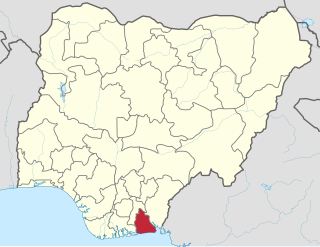
Ibiono-Ibom is a Local Government Area of Akwa Ibom State in the south-south region of Nigeria. It has its administrative headquarters at Oko Ita.
Mbo is located in the South Eastern part of Nigeria and is a Local Government Area in Akwa Ibom State. Following the local government creation exercise of the federal government in 1989 Mbo Local Government Area was carved out of Oron Division same year.
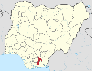
Udung-Uko is a Local Government Area of Nigeria located in the south east Akwa Ibom State that was created in December 1996.
Aba North is a Local Government Area in Aba, Abia State, Nigeria. In the year (1991) Aba North local government was created. The headquarters is at Eziama Uratta. It is amongst the local governments that make up Abia South senatorial zone. Aba North is in the South East geopolitical zone of Nigeria. The Igbo ethnic group is predominant in the area. The people of the area are mostly Christians and traditional worshippers with Igbo and English as the commonly spoken languages. Aba North, an integral part of Ngwaland, consists of indigenes and migrants from other parts of the state who reside in Aba for enterpreneural and other purposes
Ikwuano is a Local Government Area of Abia State, Nigeria. Its headquarters is in Isiala Oboro. The name 'Ikwuano' etymologically indicates that there are four different ancient kingdoms that make up the community called Ikwuano. These include Oboro, Ibere, Ariam/Usaka and Oloko.
Isiala-Ngwa North is a Local Government Area of Abia State, Nigeria. Its headquarters is Okpuala-Ngwa.

Ukwa West is a Local Government Area in Abia State, Nigeria. Its headquarters is in the town of Oke Ikpe.

Ovia North-East is a Local Government Area of Edo State, Nigeria. Its headquarters are in the town of Okada.
Oron is a coastal city and Local Government Area in Akwa Ibom State, Nigeria. It is home to the Maritime Academy of Nigeria and the Oron Museum.

Okechukwu Nwadiuto Emuchay, also referred to as "Okey Emuchay," is a diplomat and formerly Nigeria's Consul-General to South Africa.
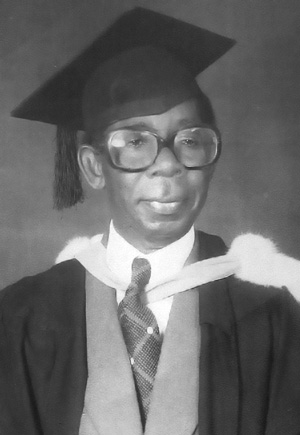
Dick W. Emuchay, also referred to as "Sir D. W. Emuchay", was a British-Nigerian medical doctor and administrator. He served as the first chairman of the Public Service Commission of the East Central State. In 1981, Samuel Onunaka Mbakwe, Governor of Imo State, appointed Emuchay as the Pro-Chancellor and Chairman Governing Council of the newly created Imo State University, later Abia State University He served in that position until 1985. He is reputed to have set up the first privately run rural hospital, when in 1961 he set up a 180-bed cottage hospital in his home town of Azumini, in Ukwa East, Abia State.

Lists of villages in Nigeria organised by state:
Ariam/Usaka is one of the four principal clans of Ikwuano Local Government Area, Abia State, Nigeria. Ariam/Usaka belongs to the Isuogu family. Ariam itself is made up of three subgroups namely; Ariam, Ekpiri and Usaka. This clan borders Ibere and Oboro to the north, Oloko to the west, as well as several Ibibio communities in Akwa Ibom State to its eastern and southern borders. Forde and Jones categorized the Isuogu family in the Ohuhu-Ngwa cluster of the Southern Igbo area.
Ekwelu is a village in the Ariam/Usaka community of Ikwuano Local Government Area in Abia State, Nigeria. It belongs to the Agumba Autonomous Community. HRH Eze Joseph Obaji is the paramount ruler of Agumba. Ekwelu is 31km south of Umuahia, the state capital and is situated along the Umuahia-Ikot Ekpene Federal Road.
Ndoki Ndoki also known as Ọkwa are a tribe of Igbo people in located at the hinterland. Pre-colonial Ndoki covers 450 square kilometres (170 sq mi) with rich farmland which borders Imo River on the East and Aba River in the South bounded by Ika and Obong villages. It's subgroup include Akwete, Azumini and Ohambele. Today, Ndoki people exist in Abia State, Akwa Ibom and Rivers State.


