Forks of Cacapon, formerly Forks of Capon, is an unincorporated community in Hampshire County in the U.S. state of West Virginia. The community is named for its location at the confluence of the North River and Cacapon River. Forks of Cacapon is also located at another fork: the crossroads of West Virginia Route 29, West Virginia Route 127, and Frank Haines Road.

Three Churches is an unincorporated community in Hampshire County in the U.S. state of West Virginia. The town is located north of Romney along Jersey Mountain Road at a crossroads with Three Churches Hollow Road. Originally known as Jersey Mountain, Three Churches was renamed for the three historic white wooden churches located there: Mount Bethel Church, Mount Bethel Primitive Baptist Church, and Branch Mountain United Methodist Church. The Three Churches Post Office is no longer in service.

Kirby is an unincorporated community in Hampshire County in the U.S. state of West Virginia situated along Grassy Lick Run, a tributary of North River. Kirby is located south of Romney at the crossroads of Grassy Lick Road and Rock Oak Road.

Glebe was an unincorporated community in Hampshire County, West Virginia, United States. It is situated at the lower mouth of the Trough, a gorge of the South Branch Potomac River, and is about 9.5 miles (15.3 km) southwest of Romney on South Branch River Road. The community received its name from the old stone glebehouse (parsonage) that was constructed there in the late 18th century. The stone house later became the Hampshire County Poor Farm and remains standing. The community of Sector lies directly across the river.
Creekvale is an unincorporated community in Hampshire County in the U.S. state of West Virginia. Creekvale is located southeast of Levels along the Little Cacapon River on Little Cacapon-Levels Road. Creekvale had a post office in operation from 1918 to 1935.

Neals Run is an unincorporated community in Hampshire County in the U.S. state of West Virginia. Neals Run is located south of Little Cacapon near the confluence of the Little Cacapon River and Neals Run on Spring Gap-Neals Run Road. The community derives its name from the stream.
Rada is an unincorporated community in Hampshire County in the U.S. state of West Virginia. Rada is located on U.S. Highway 220/West Virginia Route 28 between Junction and Purgitsville in southwest Hampshire County along Mill Creek. It lies at an intersection of US 220/WV 28 with Rada Road.
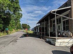
Largent is an unincorporated community village located chiefly in Morgan County and partly in Hampshire County in the U.S. state of West Virginia. Largent is located on the Cacapon River, approximately 18 miles southwest of Berkeley Springs along Cacapon Road. It is located by Old Enon Cemetery, Stony Creek, and the Cacapon River. Largent's original town name was Enon. It was most likely renamed when Postal Service found another town of Enon elsewhere in the state. The Enon name is found in local church and cemetery names. The Enon school is found on USGS maps from 1914 through 1923. The school has been open at least since the 1930s. The Baileys bought the building in 1958 and it has been a residence since.
Hancock is an unincorporated community hamlet in Morgan County in the U.S. state of West Virginia's Eastern Panhandle. It is located off Hancock Road on River Road along the Potomac River north of Berkeley Springs. Originally known as Brosius, its post office's name was changed to Hancock in 1948 to reflect its location on the Baltimore and Ohio Railroad mainline across the river from Hancock, Maryland.
Ridersville is an unincorporated community between Berkeley Springs and Stohrs Crossroads along Martinsburg Road in Morgan County, West Virginia. It is located on Pious Ridge (804 ft) where Pious Ridge Road and Peter Yost Road intersect with WV 9. Ridersville sprang up in the 19th century as a small farming community along the Martinsburg Road with a general store. It had its own operating post office until it was closed in 1903 due to the community's proximity to Berkeley Springs. During its period as an independent agrarian town, it was known as Friendship, Rider Store, Riderville, and finally as Ridersville. Today, it is merely a growing residential area of Berkeley Springs.
Spohrs Crossroads is an unincorporated community along Martinsburg Road to the west of Sleepy Creek in Morgan County in the U.S. state of West Virginia. The community was originally named Spohrs Cross Roads for the local Spohr family. It is sometimes erroneously known as Stohrs Cross Roads or Stohrs Crossroads.

Holton is a small unincorporated community in northeastern Morgan County in the U.S. state of West Virginia. Holton lies on Martinsburg Road at its junction with Cherry Run Road along Cherry Run and the Berkeley County line. Holton had its own post office in operation between 1889 and 1903. Pleasant View Elementary School, one of three elementary schools still operational in Morgan County as of 2020, is located in Holton.

Oakland is an unincorporated community in Morgan County, West Virginia. It is located along Virginia Line Road north of Unger and south of Stotlers Crossroads. Oakland is connected to Valley Road by County Route 28.
Burnt Factory is an unincorporated community in Morgan County, West Virginia north of Berkeley Springs. It is located along Sand Mine Road off Hancock Road and is the site of the U.S. Silica Company's Berkeley Springs plant. U.S. Silica is a producer of ground and unground silica sand, kaolin clay, and aplite. These materials are extracted from Warm Spring Ridge directly across U.S. Route 522 from the facility in Burnt Factory.
Dillons Run was an unincorporated community in Hampshire County, West Virginia, United States. It is located at the intersection of Dillons Run Road and Haines Road along the Dillons Run stream from which it takes its name. Dillons Run no longer has its own post office in operation. It was originally known as Luptons Mill.

Donaldson is an unincorporated community in Hampshire County in the U.S. state of West Virginia. It is located in Green Spring Valley on Green Spring Road between Green Spring and Springfield. Donaldson was once a thriving railroad community along the South Branch Valley Railroad with its own school and post office in operation.
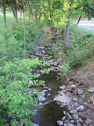
Big Run is a 4.4-mile-long (7.1 km) tributary stream of the South Branch Potomac River, belonging to the Potomac River and Chesapeake Bay watersheds. Big Run flows through the city of Romney and the campus of the West Virginia Schools for the Deaf and Blind in Hampshire County, West Virginia. The stream is known by local residents as Town Run and Town Creek.

Oakwood is an unincorporated town in Buchanan County, Virginia, located at the intersection of U.S. Route 460 and Secondary Route 624. The Appalachian College of Pharmacy is in Oakwood, on the campus of the former Garden High School.

Quick is a small unincorporated community in Kanawha County, West Virginia, United States. It is located along Indian Creek Road. The community is where Whitoak Fork and Blue Creek come together and meet. It is also where the abandoned railroad that follows Blue Creek joins the road, and follows it all the way to the community of Hitop, along Pond Fork. Its post office is closed.
Mabee Corner is an unincorporated community in Hamilton Township, Jackson County, Ohio, United States. It is located west of Oak Hill at the intersection of Bucklick Creek Road and Ohio State Route 139, at 38°54′10″N82°43′16″W.