Unionville, Orange County, New York

Last updated

Unionville
Village of Unionville
NY 284 sb, Unionville (2), Jan. 2023.jpg
Center of Unionville along NY 284
Orange County New York incorporated and unincorporated areas Unionville highlighted.svg
Location in Orange County and the state of New York.
USA New York location map.svg
Red pog.svg
Unionville
Location within the state of New York
Coordinates: 41°18′1″N74°33′42″W / 41.30028°N 74.56167°W / 41.30028; -74.56167
Country United States
State New York
County Orange
Incorporated1871
Area
[1]
  Total0.31 sq mi (0.79 km2)
  Land0.31 sq mi (0.79 km2)
  Water0.00 sq mi (0.00 km2)
Population
 (2020)
  Total592
  Density1,934.64/sq mi (747.58/km2)
Time zone UTC-5 (Eastern (EST))
  Summer (DST) UTC-4 (EDT)
Area code 845
FIPS code 36-76210
GNIS feature ID2391176 [2]
Website www.unionvilleny.org

Unionville is a village in Orange County, New York, United States. The population was 592 at the 2020 census, making it by far the smallest village in Orange County and one of the smallest in New York State.

Contents

The village is within the town of Minisink, southeast of Port Jervis, and is part of the Poughkeepsie-Newburgh-Middletown, Orange County, New York metropolitan statistical area as well as the larger New York City-Newark, New Jersey-Bridgeport, Connecticut and New York-New Jersey-Connecticut-Pennsylvania combined statistical area.

History

The settlement was founded in the early part of the 18th century, and became known as Unionville around 1820. According to tradition, the name "Unionville" was applied to the place after a land dispute had been settled. [3] Unionville was incorporated as a village in 1871. [4] Once an important economic zone in the area, its decline followed the changes in transportation which favored other locations: the Middletown and Unionville Railroad shuttled agricultural products (especially milk) as well as high school students in the first half of the 20th century. By World War II, however, improved roads and a high school built far away from the train tracks led to the end of these services; passenger service on the line ended in 1968.

Geography

Unionville is located at 41°18′1″N74°33′42″W / 41.30028°N 74.56167°W / 41.30028; -74.56167 . [5]

According to the United States Census Bureau, the village has a total area of 0.2 square mile (0.6 km2), all land.

The village is located on NY Route 284. The Appalachian Trail runs just south of the village along the New York/New Jersey state line. Unionville is adjacent to the Town of Wantage in New Jersey.

Demographics

Historical population
CensusPop.Note
1880 316
1890 3160.0%
1900 45443.7%
1910 351−22.7%
1920 40214.5%
1930 4389.0%
1940 387−11.6%
1950 45417.3%
1960 51112.6%
1970 57612.7%
1980 574−0.3%
1990 548−4.5%
2000 536−2.2%
2010 61214.2%
2020 592−3.3%
U.S. Decennial Census [6]

As of the census [7] of 2000, there were 536 people, 197 households, and 140 families residing in the village. The population density was 2,140.2 inhabitants per square mile (826.3/km2). There were 210 housing units at an average density of 838.5 per square mile (323.7/km2). The racial makeup of the village was 95.34% white, .37% African American, .37% Pacific Islander, 2.24% from other races, and 1.68% from two or more races. Hispanic or Latino of any race were 8.21% of the population.

There were 197 households, out of which 36.5% had children under the age of 18 living with them, 52.8% were married couples living together, 12.2% had a female householder with no husband present, and 28.9% were non-families. 22.3% of all households were made up of individuals, and 5.6% had someone living alone who was 65 years of age or older. The average household size was 2.70 and the average family size was 3.16.

The population of the village was spread out, with 26.3% under the age of 18, 6% from 18 to 24, 31.7% from 25 to 44, 25.7% from 45 to 64, and 10.3% who were 65 years of age or older. The median age was 38 years. For every 100 females, there were 88.7 males. For every 100 females age 18 and over, there were 87.2 males.

The median income for a household in the village was $37,222, and the median income for a family was $41,000. Males had a median income of $31,250 versus $30,000 for females. The per capita income for the village was $16,753. About 7.0% of families and 8.4% of the population were below the poverty line, including 6.3% of those under age 18 and none of those age 65 or over.

Related Research Articles

<span class="mw-page-title-main">Orange County, New York</span> County in New York, United States

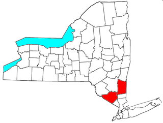
Orange County is a county located in the U.S. state of New York. As of the 2020 census, the population was 401,310. The county seat is Goshen. This county was first created in 1683 and reorganized with its present boundaries in 1798. The county is part of the Hudson Valley region of the state.

<span class="mw-page-title-main">North Middletown, New Jersey</span> Populated place in Monmouth County, New Jersey, US

North Middletown is an unincorporated community and census-designated place (CDP) within Middletown Township, in Monmouth County, in the U.S. state of New Jersey. As of the 2010 United States Census, the CDP's population was 3,295.

<span class="mw-page-title-main">Deerpark, New York</span> Town in New York, United States

Deerpark is a town in the western part of Orange County, New York, United States, and part of the New York metropolitan area. As of the 2020 Census, the population was at 7,509. The center of population of New York is located in Cuddebackville, a hamlet in Deerpark. Cuddebackville and Deerpark most prominently serve as the headquarters of both the global Falun Gong religious movement and the Shen Yun performance arts troupe, based at the Dragon Springs compound.

<span class="mw-page-title-main">Florida, Orange County, New York</span> Village in New York, United States

Florida is a village in Orange County, New York, United States. The population was 3,049 as of the 2020 census. It is part of the Poughkeepsie-Newburgh-Middletown Metropolitan Statistical Area as well as the larger New York–Newark–Bridgeport, NY-NJ-CT-PA Combined Statistical Area. The village is located in the town of Warwick, with two small northern portions in the town of Goshen. Florida is at the convergence of Routes 17A and 94.

<span class="mw-page-title-main">Greenville, Orange County, New York</span> Town in New York, United States

Greenville is a town in Orange County, New York, United States, located along the southern county and state line. The population was 4,689 at the 2020 census.

<span class="mw-page-title-main">Greenwood Lake, New York</span> Village in New York, United States

Greenwood Lake is a village in Orange County, New York, United States, in the southern part of the town of Warwick. As of the 2020 census, the population of the village was 2,994. It is part of the Poughkeepsie–Newburgh–Middletown, NY Metropolitan Statistical Area as well as the larger New York–Newark–Bridgeport Combined Statistical Area.

Highland Mills is a hamlet and former census-designated place (CDP) in Orange County, New York, United States. The population was 3,468 at the 2000 census. It is part of the Poughkeepsie–Newburgh–Middletown, NY Metropolitan Statistical Area as well as the larger New York–Newark–Bridgeport, NY-NJ-CT-PA Combined Statistical Area.

<span class="mw-page-title-main">Maybrook, New York</span> Village in New York, United States

Maybrook is a village in Orange County, New York, United States. The population was 3,150 at the 2020 census. It is part of the Poughkeepsie–Newburgh–Middletown, NY Metropolitan Statistical Area as well as the larger New York–Newark–Bridgeport, NY-NJ-CT-PA Combined Statistical Area.

<span class="mw-page-title-main">Mechanicstown, New York</span> CDP in New York, United States

Mechanicstown is a hamlet in Orange County, New York, United States. The population was 8,065 at the 2020 census. It is part of the Poughkeepsie–Newburgh–Middletown, NY Metropolitan Statistical Area as well as the larger New York–Newark–Bridgeport, NY-NJ-CT-PA Combined Statistical Area.

<span class="mw-page-title-main">Middletown, New York</span> City in New York, United States

Middletown is the largest city in Orange County, New York, United States. It lies in New York's Hudson Valley region, near the Wallkill River and the foothills of the Shawangunk Mountains. Middletown is situated between Port Jervis and Newburgh, New York. At the 2020 United States census, the city's population was 30,345, reflecting an increase of 2,259 from the 28,086 counted in the 2010 census. The ZIP Code is 10940. Middletown falls within the Kiryas Joel–Poughkeepsie–Newburgh Metropolitan Statistical Area, which belongs to the larger New York–Newark–Bridgeport, NY–NJ–CT–PA Combined Statistical Area.

<span class="mw-page-title-main">Minisink, New York</span> Town in New York, United States

Minisink is a town located in southwestern Orange County, New York, United States, northeast of the New Jersey border between the Town of Greenville and the Town of Warwick. The population was 4,621 at the 2020 census. The town is located near Interstate 84 and New York State Route 17 and lies approximately halfway between New York City and Scranton, Pennsylvania.

<span class="mw-page-title-main">Otisville, New York</span> Village in New York, United States

Otisville is a village in Orange County, New York, United States. The population was 969 at the 2020 census. It is part of the Poughkeepsie–Newburgh–Middletown, NY Metropolitan Statistical Area as well as the larger New York–Newark–Bridgeport, NY-NJ-CT-PA Combined Statistical Area.

<span class="mw-page-title-main">Scotchtown, New York</span> Hamlet and CDP in New York, United States

Scotchtown is a hamlet in the Town of Wallkill, in Orange County, New York, United States. The population was 10,578 at the 2020 census. It has the ZIP Code 10941. The hamlet is located east of the City of Middletown. It is part of the Poughkeepsie–Newburgh–Middletown, NY Metropolitan Statistical Area as well as the larger New York–Newark–Bridgeport, NY-NJ-CT-PA Combined Statistical Area.

<span class="mw-page-title-main">Wawayanda, New York</span> Town in New York, United States

Wawayanda is a town in Orange County, New York, United States. The population was 7,534 as recorded by the 2020 census. The town of Wawayanda is in the western part of the county, south of Middletown.

<span class="mw-page-title-main">Neversink, New York</span> Town in New York, United States

Neversink is a town in Sullivan County, New York, United States. The population was 3,366 at the 2020 census.

<span class="mw-page-title-main">Matamoras, Pennsylvania</span> Borough in Pennsylvania, United States

Matamoras is a borough in Pike County, Pennsylvania, United States. The population was 2,362 at the 2020 census. It is the easternmost municipality of any kind in Pennsylvania. Matamoras is part of the New York–Newark–Jersey City, NY–NJ–PA Metropolitan Statistical Area, as well as the larger New York–Newark, NY–NJ–CT–PA Combined Statistical Area.

<span class="mw-page-title-main">Chester (village), New York</span> Village in New York, United States

Chester is a village in Orange County, New York, United States. The population was 3,993 at the 2020 census. It was named after the City of Chester in the Cheshire region of northwest England. Chester is part of the Poughkeepsie–Newburgh–Middletown, NY Metropolitan Statistical Area as well as the larger New York–Newark–Bridgeport, NY-NJ-CT-PA Combined Statistical Area.

<span class="mw-page-title-main">Monroe (village), New York</span> Village in New York, United States

Monroe is a village in Orange County, New York, United States. The population was 9,343 at the 2020 census. It is part of the Poughkeepsie–Newburgh–Middletown, NY Metropolitan Statistical Area as well as the larger New York–Newark–Bridgeport, NY-NJ-CT-PA Combined Statistical Area. The community is not named after President James Monroe, but rather after an early 19th-century New York state senator.

<span class="mw-page-title-main">Kiryas Joel-Poughkeepsie-Newburgh metropolitan area</span> Metropolitan statistical area in New York, United States

The Kiryas Joel-Poughkeepsie-Newburgh, NY Metropolitan Statistical Area, as defined by the United States Office of Management and Budget, is an area consisting of two counties in New York's Hudson Valley, with the municipalities of Kiryas Joel, Poughkeepsie, and Newburgh as its principal cities. As of the 2020 census, the MSA had a population of 679,221. The area was centered on the urban area of Poughkeepsie-Newburgh. Prior to July 2023, it was known as the Poughkeepsie-Newburgh-Middletown, NY Metropolitan Statistical Area; whereupon it was renamed to its current name, to reflect population changes among its largest municipalities.

<span class="mw-page-title-main">Monroe, New York</span> Town in Orange County, New York, US

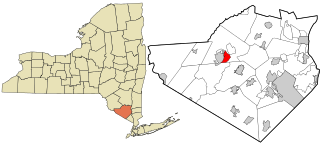
Monroe is a town in Orange County, New York, United States. The population was 21,387 at the 2020 census, compared to 39,912 at the 2010 census; the significant fall in census population was due to the secession of the town of Palm Tree in 2019. The town is named after President James Monroe.

References

  1. "ArcGIS REST Services Directory". United States Census Bureau. Retrieved September 20, 2022.
  2. US Board on Geographic Names, United States Geological Survey. Accessed August 1, 2015.
  3. Eager, Samuel Watkins (1846). An Outline History of Orange County: Together with Local Tradition and Short Biographical Sketches of Early Settlers, Etc. T. E. Henderson. p. 417.
  4. U.S. Geological Survey Geographic Names Information System: Unionville, Orange County, New York
  5. "US Gazetteer files: 2010, 2000, and 1990". United States Census Bureau. February 12, 2011. Retrieved April 23, 2011.
  6. "Census of Population and Housing". Census.gov. Retrieved June 4, 2015.
  7. "U.S. Census website". United States Census Bureau . Retrieved January 31, 2008.