
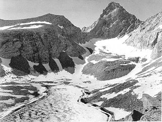
Mount Lyell is the highest point in Yosemite National Park, at 13,114 feet (3,997 m). It is located at the southeast end of the Cathedral Range, 1.2 miles (1.9 km) northwest of Rodgers Peak. The peak as well as nearby Lyell Canyon is named after Charles Lyell, a well-known 19th century geologist. The peak had one of the last remaining glaciers in Yosemite, Lyell Glacier. The Lyell Glacier is currently considered to be a permanent ice field, not a living glacier. Mount Lyell divides the Tuolumne River watershed to the north, the Merced to the west, and the Rush Creek drainage in the Mono Lake Basin to the southeast.

Mount Tom is a large and prominent peak near the city of Bishop in Inyo County of eastern California. It is in the Sierra Nevada and east of the Sierra Crest. The mountain is also in the John Muir Wilderness.

Mount Muir is a peak in the Sierra Nevada of California, 0.95 miles (1.5 km) south of Mount Whitney. This 14,018-foot (4,273 m) peak is named in honor of Scottish-born John Muir, a famous geologist, conservationist and founder of the Sierra Club. The southernmost section of the John Muir Trail contours along the west side of Mount Muir near its summit and ends on the summit of Mount Whitney.

Mount Williamson, at an elevation of 14,379 feet (4,383 m), is the second-highest mountain in both the Sierra Nevada range and the state of California, and the sixth-highest peak in the contiguous United States.

North Palisade is the third-highest mountain in the Sierra Nevada range of California. It is the highest peak of the Palisades group of peaks in the central part of the range. It sports a small glacier and several highly prized rock climbing routes on its northeast side.

Mount Sill is one of the fourteeners of the Sierra Nevada in California. It is located in the Palisades, a group of prominent rock peaks with a few small glaciers on their flanks. Mount Sill is located 0.6 miles (1 km) east of North Palisade, the high point of the group. The two peaks are connected by a high, rocky ridge, on the north side of which lies the Palisade Glacier. Mount Sill lies on the main Sierra Crest, but is at a point where the crest turns sharply, giving it particularly striking summit views. On one side is Kings Canyon National Park and Fresno County; on the other is the John Muir Wilderness, Inyo National Forest and Inyo County.

Mount Langley is a mountain located on the crest of the Sierra Nevada, on the boundary between Inyo and Tulare counties in eastern California, in the United States. To the east is the Owens Valley, and to the west is the Kern River Valley. It is the ninth-highest peak in the state and the seventh-highest in the Sierra. Mount Whitney, the highest peak in the contiguous United States, lies 4.8 miles (7.7 km) to the northwest. Mount Langley also has the distinction of being the southernmost fourteener in the United States.

Mount Russell is a peak in the Sierra Nevada mountain range in the U.S. state of California, about 0.8 miles (1.3 km) north of Mount Whitney. With an elevation of 14,094 feet (4,296 m) it is the seventh-highest peak in the state.

Split Mountain is a fourteener in the Sierra Nevada of the U.S. state of California, near the southeast end of the Palisades group of peaks. It is the only fourteener in the watershed of the South Fork Kings River, and rises to 14,064 ft (4,287 m), making it the eighth-highest peak in the state.

Mount Tyndall is a peak in the Mount Whitney region of the Sierra Nevada in the U.S. state of California. At 14,025 feet (4,275 m), it is the tenth highest peak in the state. The mountain was named in honor of the Irish scientist and mountaineer, John Tyndall.

Banner Peak is the second tallest peak in the Ritter Range of California's Sierra Nevada. The mountain is 12,942 feet (3,945 m) tall, and there are several glaciers on its slopes. It lies within the boundaries of the Ansel Adams Wilderness; at the foot of the peak lie Garnet Lake, Lake Ediza, and the famous Thousand Island Lake. Banner Peak is near the town of Mammoth Lakes; from there, climbers can hike to the foot of the mountain where various routes reach the summit, the easiest of which is a class 2 from the west end of Thousand Island Lake and then the saddle between Banner Peak and the slightly taller Mount Ritter. Other nearby lakes include Lake Catherine and Shadow Lake.

Mount Barnard is a mountain in the U.S. state of California, and has the dubious distinction of being the highest thirteener, a peak between 13,000 and 13,999 feet in elevation, in the United States. It is located on the Sierra Crest and straddles the boundary between Tulare and Inyo counties about 2 miles (3 km) southwest of Mount Williamson, the second-highest peak in the state; Mount Barnard is the twelfth-highest.

Mount Agassiz, at 13,899 feet (4,236 m), is one of the twenty highest peaks of California. It is the northernmost and easiest to climb of the major Palisades summits. This peak is not to be confused with the 9967 ft peak by the same name in Desolation Wilderness, also in the California Sierra.

Mount Maclure is the nearest neighbor to Mount Lyell, the highest point in Yosemite National Park. Mount Maclure is the fifth-highest mountain of Yosemite. Mount Maclure is located at the southeast end of the Cathedral Range, about 0.6 miles (0.97 km) northwest of Lyell. The summit is on the boundary between Madera and Tuolumne counties which is also the boundary between the park and the Ansel Adams Wilderness. It was named in honor of William Maclure, a pioneer in American geology who produced the first geological maps of the United States. Maclure Glacier, one of the last remaining glaciers in Yosemite, is situated on the mountain's northern flank.
Junction Peak is a thirteener in the Sierra Nevada. Joseph Nisbet LeConte chose this name in 1896, noting that it marks the point where the Sierra Crest crosses the water divide of the Kern and Kings rivers. Today it also is the boundary between Inyo and Tulare counties, and of Kings Canyon National Park, Sequoia National Park and the John Muir Wilderness.

Mount Keith is a mountain on the crest of California's Sierra Nevada, between Mount Bradley to the north, and Junction Peak to the southwest. Its north and west facing slopes feed the Kings River watershed by way of Bubbs Creek, and its east and south slopes feed the Owens River via Shepherd Creek. By the same dividing line, Keith stands on the boundary of Kings Canyon National Park to the northwest, and the John Muir Wilderness to the southeast. It is a thirteener, a mountain which has a height over 13000 feet.

Mount Mallory is a mountain located in the Sierra Nevada of California. The boundary between Inyo National Forest and Sequoia National Park runs across the summit. The peak was named in memory of George H. Leigh Mallory, of the 1924 British Mount Everest expedition, who was lost on Mount Everest, June, 1924. Norman Clyde advanced Mallory's and Andrew Irvine's names following their loss after attaining the highest altitude reached by a mountain climber.

Mount Mills is a Thirteener and California 4000 meter peak, on the Sierra Crest, north of Mount Abbot and south of Mono Pass in the Sierra Nevada.

Mount McAdie is a summit on the crest of the Sierra Nevada, and is located 2.1 miles (3.4 km) south of Mount Whitney. It has three summits, with the north peak being the highest. The summit ridge marks the boundary between Sequoia National Park and the John Muir Wilderness. It is also on the boundary between Inyo and Tulare counties. Lone Pine, 12.4 miles (20.0 km) to the northeast, is in the Owens Valley on U.S. 395.

Mount Irvine is a mountain in the Sierra Nevada of California. The summit is in the Inyo National Forest and the John Muir Wilderness. The peak was named in memory of Andrew Irvine, of the 1924 British Mount Everest expedition, who perished on Mount Everest, June, 1924. Norman Clyde proposed Irvine's and George H. Leigh Mallory's names following their loss after attaining the highest altitude reached by a mountaineer.


