
Yala (යාල) National Park is the most visited and second largest national park in Sri Lanka, bordering the Indian Ocean. The park consists of five blocks, two of which are now open to the public, and also adjoining parks. The blocks have individual names such as, Ruhuna National Park, and Kumana National Park or 'Yala East' for the adjoining area. It is situated in the southeast region of the country, and lies in Southern Province and Uva Province. The park covers 979 square kilometres (378 sq mi) and is located about 300 kilometres (190 mi) from Colombo. Yala was designated as a wildlife sanctuary in 1900, and, along with Wilpattu was one of the first two national parks in Sri Lanka, having been designated in 1938. The park is best known for its variety of wild animals. It is important for the conservation of Sri Lankan elephants, Sri Lankan leopards and aquatic birds.

Batticaloa is a major city in the Eastern Province, Sri Lanka, and its former capital. It is the administrative capital of the Batticaloa District. The city is the seat of the Eastern University of Sri Lanka and is a major commercial centre. It is on the east coast, 111 kilometres (69 mi) south of Trincomalee, and is situated on an island. Pasikudah is a popular tourist destination situated 35 km (22 mi) northwest with beaches and flat year-round warm-water shallow-lagoons.
The Eastern Province is one of the nine provinces of Sri Lanka, the first level administrative division of the country. The provinces have existed since the 19th century but did not have any legal status until 1987 when the 13th Amendment to the Constitution of Sri Lanka established provincial councils. Between 1988 and 2006 the province was temporarily merged with the Northern Province to form the North Eastern Province. The capital of the province is Trincomalee.
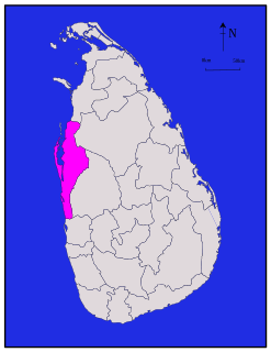
Puttalam is a district situated near to the west coast of Sri Lanka. It has an area of 3,072 km2 (1,186 sq mi). Along with the Kurunegala District, it formulates the North Western Province of Sri Lanka. The district capital is Puttalam, which borders the Kala Oya and Modaragam Aru in the north, Anuradhapura District and Kurunegala District in the east, Ma Oya in the south, and the Indian Ocean in the west. Puttalam is well known for its picturesque lagoons, popular for shallow sea fishing and prawn farming activities. The town of Kalpitiya, and the Kalpitiya Peninsula, is located in this district.
Jaffna Lagoon is a large lagoon off Jaffna District and Kilinochchi District, northern Sri Lanka. The lagoon is surrounded by the densely populated Jaffna Peninsula containing palmyra palms, coconut plantations, and rice paddies. There are numerous fishing villages and some salt pans. The lagoon has extensive mudflats, seagrass beds and some mangroves. The lagoon attracts a wide variety of water birds including American flamingoes, ducks, gulls, terns and other shorebirds.

Bundala National Park is an internationally important wintering ground for migratory water birds in Sri Lanka. Bundala harbors 197 species of birds, the highlight being the greater flamingo, which migrate in large flocks. Bundala was designated a wildlife sanctuary in 1969 and redesignated to a national park on 4 January 1993. In 1991 Bundala became the first wetland to be declared as a Ramsar site in Sri Lanka. In 2005 the national park was designated as a biosphere reserve by UNESCO, the fourth biosphere reserve in Sri Lanka. The national park is situated 245 kilometres (152 mi) southeast of Colombo.
Kokkilai lagoon is an estuarine lagoon in Mullaitivu District and Trincomalee District, north-east Sri Lanka. The town of Kokkilai is located on a sand bar between the lagoon and the Indian Ocean.
Vadamarachchi lagoon is a lagoon in Jaffna District, northern Sri Lanka. The lagoon is sometimes referred to as Thondamannar lagoon. The lagoon separates the Vadamarachchi region from the Valikamam and Thenmarachchi regions.

Chundikkulam Lagoon is a lagoon in Jaffna District and Kilinochchi District, north-east Sri Lanka. The town of Chundikkulam is located on a narrow piece of land between the lagoon and the Indian Ocean. The lagoon is sometimes referred to as Elephant Pass Lagoon.
Chalai Lagoon is a lagoon in Mullaitivu District, north-east Sri Lanka. The town of Chalai is located on a sand bar between the lagoon and the Indian Ocean.
Nai Aru Lagoon is an estuarine lagoon in Mullaitivu District, north-east Sri Lanka.
Ullackalie Lagoon is a lagoon in Trincomalee District, eastern Sri Lanka.

Batticaloa Lagoon is a very large estuarine lagoon in Batticaloa District, eastern Sri Lanka. The city of Batticaloa is located on land between the lagoon and the Indian Ocean.Batticaloa district is flourished with three lagoons, such Batticaloa lagoon, Valaichchenai Lagoon and Vakari Lagoon. Among them, Batticaloa lagoon is the largest lagoon in Batticaloa District. Batticaloa lagoon is a long and narrow lagoon situated in the east coast of Sri Lanka with the total area of approximately 11,500 ha of water.

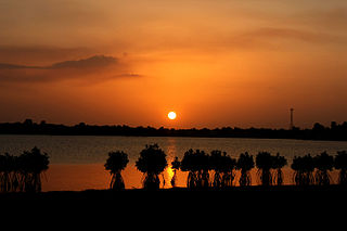
Negombo Lagoon is a large estuarine lagoon in Negombo, south-west Sri Lanka.
Mundal Lagoon is a lagoon in Puttalam District, western Sri Lanka. The lagoon is sometimes referred to as Mundal Lake.

The Puttalam Lagoon is a large 327 km2 (126 sq mi) lagoon in the Puttalam District, western Sri Lanka.

Valvettithurai, sometimes shortened as VVT or Valvai, is a coastal town of Jaffna District on the northeast coast of the Jaffna Peninsula in Northern Province, Sri Lanka governed by an Urban Council of the same name. Valvettithurai was historically known for its seafaring traditions and olden transnational shipping trade.

Valaichchenai Lagoon is an estuarine lagoon in Batticaloa District, eastern Sri Lanka. Batticaloa district has three lagoons, such Valaichchenai Lagoon, Batticaloa Lagoon and Vakari Lagoon. Valaichchenai lagoon is situated in populated areas of Valaichchenai, Oddamavadi

Malala-Ambilikala Lagoons are two interconnected coastal water-bodies located inside the Bundala National Park, Hambantota District in the Southern Province, Sri Lanka. It is 260 km (160 mi) from Colombo to the arid south. The Malala-Ambilikala Lagoons are two of the three key lagoons located within the Bundala Ramsar wetlands.
Sri Lanka is a relatively small continental island, it exhibits a remarkable diversity of forest types, which are among the biologically one of richest forests in Asia. In these forests plant species show extraordinary patterns of localized distribution. Sri Lanka's forest became one of highest density of species diversity in the world. Sri Lanka natural forest cover about 12,493 km2 29.46% According to the National Red List said, Sri Lanka counts 253 land species, 245 species of butterflies, 240 birds, 211 reptiles, 748 evaluated vertebrates and 1,492 invertebrates. Forest coverage is about 70% tropical dry monsoon forests, 15% tropical moist monsoon forests and 5% tropical lower montane forests. By the dawn of the 19th century, Sri Lanka's forest cover was estimated at up to 70% of the total land area. Since then, the forest cover has decreased progressively over time. Significant loss of Sri Lanka's forest cover was first reported in the 19th century, with the introduction of plantation agricultural crops such as tea and vegetables. Commercial timber extraction policy of colonial rulers (British colonial time also led to clearing of forests in the dry zone. Irrigation development and agricultural expansions have been identified as key drivers of forest cover change.
