Uppermill

Last updated

Uppermill
Uppermill and Railway.jpg
View over Uppermill
Greater Manchester UK location map 2.svg
Red pog.svg
Uppermill
Location within Greater Manchester
OS grid reference SD938090
  London 161 miles (261 km) SSE
Civil parish
Metropolitan borough
Metropolitan county
Region
Country England
Sovereign state United Kingdom
Post town OLDHAM
Postcode district OL3
Dialling code 01457
Police Greater Manchester
Fire Greater Manchester
Ambulance North West
UK Parliament
List of places
UK
England
Greater Manchester
53°32′56″N2°00′14″W / 53.549°N 2.004°W / 53.549; -2.004

Uppermill is a village in the civil parish of Saddleworth in the Metropolitan Borough of Oldham, Greater Manchester, England. Historically in the West Riding of Yorkshire, it lies on the River Tame in a valley amongst the South Pennines with the Peak District National Park directly to the east, 5 miles (8.0 km) east of Oldham and 11 miles (17.7 km) northeast of Manchester. Uppermill and the neighbouring village of Dobcross have a combined population of 7,500. [1]

Contents

History

Uppermill Civic Hall (in the centre of the picture) Court Street Uppermill - geograph.org.uk - 1185741.jpg
Uppermill Civic Hall (in the centre of the picture)

Although there is evidence of Roman activity in the area, [2] the history of Uppermill is dominated by the expansion of wool and cotton spinning into the area during the Industrial Revolution, with the construction of several mills. [3] Uppermill Civic Hall was completed in 1859. [4]

Demography

Dobcross/Uppermill compared
2001 UK censusDobcross/Uppermill [1] Oldham (borough) [5] England
Total population7,475217,27349,138,831
White98.3%86.191%
Asian0.6%11.94.6%
Black0.2%0.62.3%

The villages of Uppermill and Dobcross were treated as a single entity by the Office for National Statistics in the 2001 United Kingdom Census. As such, there are no demographic statistics for the village on its own. The statistics given here are for the combined population of Uppermill and Dobcross, which are about half a mile apart.

At the 2001 census, the area had a population of 7,475. Its population density was 10,324 inhabitants per square mile (3,986/km2), with a 100 to 92.6 female-to-male ratio. [6] Of those over 16 years old, 22.5% were single (never married), 49.6% married, and 7.8% divorced. [7] The 3,225 households in the area included 27.7% one-person, 43.2% married couples living together, 8.1% were co-habiting couples, and 6.9% single parents with their children. [8] Of those aged 16–74, 21.1% had no academic qualifications, significantly below the averages of Oldham (37.7%) and England (28.9%). [9] [10]

At the 2001 UK census, 79.6% of residents in the area reported themselves as being Christian, 0.3% Muslim, 0.3% Hindu, 0.2% Buddhist and 0.2% Jewish. The census recorded 13.3% as having no religion, 0.2% had an alternative religion and 6.0% did not state their religion. [11]

Geography

Transport

The nearest railway station to Uppermill is Greenfield with an hourly service provided in both directions by TransPennine Express between Manchester Piccadilly and Huddersfield.

Bus services through the village include (from March 2024):

Related Research Articles

<span class="mw-page-title-main">Ashton-under-Lyne</span> Market town in Greater Manchester, England

Ashton-under-Lyne is a market town in Tameside, Greater Manchester, England. The population was 48,604 at the 2021 census. Historically in Lancashire, it is on the north bank of the River Tame, in the foothills of the Pennines, 6 miles (9.7 km) east of Manchester.

<span class="mw-page-title-main">Dukinfield</span> Town in Greater Manchester, England

Dukinfield is a town in Tameside, Greater Manchester, England, on the south bank of the River Tame opposite Ashton-under-Lyne, 6.3 miles (10.1 km) east of Manchester. At the 2011 Census, it had a population of 19,306.

<span class="mw-page-title-main">Mossley</span> Town in Tameside, Greater Manchester, England

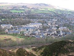
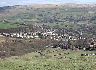
Mossley (/ˈmɒzli/) is a town and civil parish in Tameside, Greater Manchester, England. It is located in the upper Tame Valley and the foothills of the Pennines, 3 miles (4.8 km) south-east of Oldham and 9 miles (14.5 km) east of Manchester.

<span class="mw-page-title-main">Saddleworth</span> Human settlement in England

Saddleworth is a civil parish of the Metropolitan Borough of Oldham in Greater Manchester, England. It comprises several villages and hamlets as well as suburbs of Oldham on the west side of the Pennine hills.

<span class="mw-page-title-main">Rochdale</span> Town in Greater Manchester, England

Rochdale is a town in Greater Manchester, England, and the administrative centre of the Metropolitan Borough of Rochdale. In the 2021 census the town had a population of 111,261, compared to 223,773 for the wider borough. Rochdale is in the foothills of the South Pennines and lies in the dale (valley) of the River Roch, 5 miles (8 km) northwest of Oldham, and 10 miles (16 km) northeast of Manchester.

<span class="mw-page-title-main">Metropolitan Borough of Oldham</span> Borough of Greater Manchester, England

The Metropolitan Borough of Oldham is a metropolitan borough of Greater Manchester in England. It is named after its largest town, Oldham. The borough had a population of 242,072 in 2021, making it the sixth-largest district by population in Greater Manchester. The borough spans 142.3 square kilometres (54.9 sq mi).

<span class="mw-page-title-main">Greenfield, Greater Manchester</span> Village in Greater Manchester, England

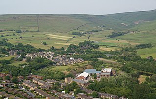
Greenfield is a village in the civil parish of Saddleworth in the Metropolitan Borough of Oldham, in Greater Manchester, England. It is 4 miles (6.4 km) east of Oldham and 13 miles (21 km) north-east of Manchester. It is located in a broad rural area at the southern edge of the South Pennines; Dovestone Reservoir, Chew Reservoir and Greenfield Reservoir lie to the east of the village in the Peak District National Park.

<span class="mw-page-title-main">Royton</span> Town in Greater Manchester

Royton is a town in the Metropolitan Borough of Oldham, Greater Manchester, England, with a population of 21,284 in 2011. Close to the source of the River Irk, near undulating land at the foothills of the South Pennines, it is 1.7 miles (2.7 km) northwest of Oldham, 3.2 miles (5.1 km) southeast of Rochdale and 7.6 miles (12.2 km) northeast of Manchester.

<span class="mw-page-title-main">Delph</span> Village in Saddleworth, Greater Manchester, England

Delph is a village in the civil parish of Saddleworth in the Metropolitan Borough of Oldham, in Greater Manchester, England. Historically within the West Riding of Yorkshire, it lies amongst the Pennines on the River Tame below the village of Denshaw, 4.0 miles (6.4 km) east-north-east of Oldham and 1.8 miles (2.9 km) north-north-west of Uppermill.

<span class="mw-page-title-main">Mellor, Greater Manchester</span> Human settlement in England

Mellor is a village in Greater Manchester, England, lying between Marple Bridge and New Mills, Derbyshire.

<span class="mw-page-title-main">Greater Manchester Built-up Area</span> Conurbation in England

The Greater Manchester Built-up Area is an area of land defined by the Office for National Statistics (ONS), consisting of the large conurbation that encompasses the urban element of the city of Manchester and the metropolitan area that forms much of Greater Manchester in North West England. According to the United Kingdom Census 2011, the Greater Manchester Built-up Area has a population of 2,553,379 making it the second most populous conurbation in the United Kingdom after the Greater London Built-up Area. This was an increase of 14% from the population recorded at the United Kingdom Census 2001 of 2,240,230, when it was known as the Greater Manchester Urban Area.

<span class="mw-page-title-main">Diggle, Greater Manchester</span> Human settlement in England

Diggle is a village in the civil parish of the Saddleworth in Metropolitan Borough of Oldham, in Greater Manchester, England. The village is situated on the moorlands of the Pennine hills.

The Delph Donkey was a line of the London and North Western Railway (LNWR) in northern England, which opened in 1849 to connect Oldham, Greenfield and Delph to the main Huddersfield to Manchester line.

<span class="mw-page-title-main">Austerlands</span> Human settlement in England

Austerlands is a suburban area of Saddleworth, a civil parish within the Metropolitan Borough of Oldham, in Greater Manchester, England. It occupies a hillside amongst the Pennines, between the villages of Lees and Scouthead. It is traversed by the A62 road.

<span class="mw-page-title-main">Scouthead</span> Human settlement in England

Scouthead is a village in the civil parish of Saddleworth in the Metropolitan Borough of Oldham, in Greater Manchester, England. It is traversed by the A62 road, and occupies a hillside amongst the Pennines.

<span class="mw-page-title-main">Grotton</span> Human settlement in England

Grotton is a residential area in Saddleworth, a civil parish of the Metropolitan Borough of Oldham, in Greater Manchester, England. Located along the A669 road, it forms a continuous urban area with Austerlands and Springhead, which in turn link to Lees and Oldham, all of which are to Grotton's west.

<span class="mw-page-title-main">Dobcross</span> Human settlement in England

Dobcross is a village in the civil parish of Saddleworth in the Metropolitan Borough of Oldham in Greater Manchester, England. It is in a valley in the South Pennines, along the course of the River Tame and the Huddersfield Narrow Canal, 4.2 miles (6.8 km) east-northeast of Oldham and 13 miles (21 km) west-southwest of Huddersfield.

<span class="mw-page-title-main">Denshaw</span> Village in Saddleworth, Greater Manchester

Denshaw is a village in the civil parish of Saddleworth in the Metropolitan Borough of Oldham, in Greater Manchester, England. It lies by the source of the River Tame, high amongst the Pennines above the village of Delph, 4.6 miles (7.4 km) northeast of Oldham,3.3 miles (5.3 km) north-northwest of Uppermill and Shaw and Crompton. It has a population of around 500.

Saddleworth is a civil parish in the Metropolitan Borough of Oldham, Greater Manchester, England. It lies between the town of Oldham and the Pennine hills, and it is largely rural, with agricultural land and moorland. It also includes suburban areas to the east of Oldham. The principal settlements are Austerlands, Delph, Denshaw, Diggle, Dobcross, Grasscroft, Greenfield, Grotton, Lydgate, Springhead, and Uppermill. The parish contains 385 listed buildings that are recorded in the National Heritage List for England. Of these, five are listed at Grade II*, the middle grade, and the others are at Grade II, the lowest grade.

Saddleworth is a civil parish in the Metropolitan Borough of Oldham, Greater Manchester, England. It lies between the town of Oldham and the Pennine hills, and it is largely rural, with agricultural land and moorland. It also includes suburban areas to the east of Oldham. The principal settlements are Austerlands, Delph, Denshaw, Diggle, Dobcross, Grasscroft, Greenfield, Grotton, Lydgate, Springhead, and Uppermill. The parish contains 385 listed buildings that are recorded in the National Heritage List for England. Of these, five are listed at Grade II*, the middle grade, and the others are at Grade II, the lowest grade.

References

  1. 1 2 "Census 2001 Key Statistics - Urban area results by population size of urban area". ons.gov.uk. Office for National Statistics. 22 July 2004. KS06 Ethnic group Page white excel.png. Retrieved 22 April 2009.
  2. "Bronze Age dagger retrieved near proposed windfarm". Stonepages.com. 14 February 2004. Retrieved 17 April 2008.
  3. "Uppermill". Canal and River Trust. Retrieved 24 February 2024.
  4. Theakstone, Wilfred. "Saddleworth" (PDF). Manchester Geographical Society. Retrieved 23 February 2024.
  5. "Oldham Metropolitan Borough ethnic group". Statistics.gov.uk. Retrieved 22 April 2009.
  6. "Census 2001 Key Statistics - Urban area results by population size of urban area". ons.gov.uk. Office for National Statistics. 22 July 2004. KS01 Usual resident population Page white excel.png. Retrieved 22 April 2009.
  7. "Census 2001 Key Statistics - Urban area results by population size of urban area". ons.gov.uk. Office for National Statistics. 22 July 2004. KS04 Marital status Page white excel.png. Retrieved 22 April 2009.
  8. "Census 2001 Key Statistics - Urban area results by population size of urban area". ons.gov.uk. Office for National Statistics. 22 July 2004. KS20 Household composition Page white excel.png. Retrieved 22 April 2009.
  9. "Oldham Metropolitan Borough key statistics". Statistics.gov.uk. Retrieved 22 April 2009.
  10. "Census 2001 Key Statistics - Urban area results by population size of urban area". ons.gov.uk. Office for National Statistics. 22 July 2004. KS13 Qualifications and students Page white excel.png. Retrieved 22 April 2009.
  11. "Census 2001 Key Statistics - Urban area results by population size of urban area". ons.gov.uk. Office for National Statistics. 22 July 2004. KS07 Religion Page white excel.png. Retrieved 22 April 2009.