Ursensollen

Last updated
Ursensollen
St Vitus - Ursensollen 058.JPG
Church of Saint Vitus
Flagge ursensollen.png
DEU Ursensollen COA.svg
Location of Ursensollen within Amberg-Sulzbach district
Ursensollen in AS.svgKönigsteinHirschbachKastlEichen (unincorporated area)FreudenbergEnsdorfRiedenHohenburg
Germany adm location map.svg
Red pog.svg
Ursensollen
Bavaria location map.svg
Red pog.svg
Ursensollen
Coordinates: 49°24′4″N11°45′28″E / 49.40111°N 11.75778°E / 49.40111; 11.75778
Country Germany
State Bavaria
Admin. region Oberpfalz
District Amberg-Sulzbach
Government
   Mayor (202026) Albert Geitner [1]
Area
  Total72.91 km2 (28.15 sq mi)
Elevation
537 m (1,762 ft)
Population
 (2022-12-31) [2]
  Total3,812
  Density52/km2 (140/sq mi)
Time zone UTC+01:00 (CET)
  Summer (DST) UTC+02:00 (CEST)
Postal codes
92289
Dialling codes 09628
Vehicle registration AS
Website www.ursensollen.de

Ursensollen is a municipality in the district of Amberg-Sulzbach in Bavaria in Germany.

Contents

Geography

Ursensollen is in the region Upper Palatinate-North about 10 km to the west of Amberg.

Apart from Ursensollen the municipality consists of the following villages: [3]

Population

The districts of the town had a population of 2,678 in 1970, 3,518 in 2000, and 3,745 in 2009.

Related Research Articles

<span class="mw-page-title-main">Freudenberg, Bavaria</span> Municipality in Bavaria, Germany

Freudenberg is a municipality in the Amberg-Sulzbach district, in Bavaria, Germany. It is situated approximately 10 km north-east of Amberg.

<span class="mw-page-title-main">Kümmersbruck</span> Municipality in Bavaria, Germany

Kümmersbruck is a municipality in the Amberg-Sulzbach district, in the state of Bavaria, Germany. It is situated 3 km southeast of Amberg. A division of the German Military is stationed here. Kümmersbruck is split up in 7 districts: Kümmersbruck, Haselmühl, Gärmersdorf, Moos, Haidweiher, Penkhof, Lengenfeld and Engelsdorf. The river Vils crosses the municipality.

<span class="mw-page-title-main">Nabburg</span> Town in Bavaria, Germany

Nabburg is a municipality in the district of Schwandorf, in Bavaria, Germany. It is situated on the river Naab, 23 km east of Amberg.

<span class="mw-page-title-main">Schnaittenbach</span> Town in Bavaria, Germany

Schnaittenbach is a town in the Amberg-Sulzbach district, in Bavaria, Germany. It is situated 16 km northeast of Amberg.

<span class="mw-page-title-main">Ammerthal</span> Municipality in Bavaria, Germany

Ammerthal is a municipality in the district of Amberg-Sulzbach in Bavaria in Germany.

<span class="mw-page-title-main">Birgland</span> Municipality in Bavaria, Germany

Birgland is a municipality in the district of Amberg-Sulzbach in Bavaria in Germany.

<span class="mw-page-title-main">Ebermannsdorf</span> Municipality in Bavaria, Germany

Ebermannsdorf is a municipality in the district of Amberg-Sulzbach in Bavaria in Germany.

<span class="mw-page-title-main">Edelsfeld</span> Municipality in Bavaria, Germany

Edelsfeld is a municipality in the district of Amberg-Sulzbach in Bavaria, Germany.

<span class="mw-page-title-main">Ensdorf, Bavaria</span> Municipality in Bavaria, Germany

Ensdorf is a municipality in the district of Amberg-Sulzbach in Bavaria in Germany.

<span class="mw-page-title-main">Freihung</span> Municipality in Bavaria, Germany

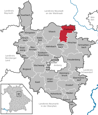
Freihung is a municipality in the district of Amberg-Sulzbach in Bavaria in Germany.

<span class="mw-page-title-main">Gebenbach</span> Municipality in Bavaria, Germany

Gebenbach is a municipality in the district of Amberg-Sulzbach in Bavaria in Germany.

<span class="mw-page-title-main">Hohenburg, Bavaria</span> Municipality in Bavaria, Germany

Hohenburg is a municipality in the district of Amberg-Sulzbach in Bavaria in Germany.

<span class="mw-page-title-main">Illschwang</span> Municipality in Bavaria, Germany

Illschwang is a municipality in the district of Amberg-Sulzbach in Bavaria in Germany.

<span class="mw-page-title-main">Poppenricht</span> Municipality in Bavaria, Germany

Poppenricht is a municipality in the district of Amberg-Sulzbach in Bavaria in Germany.

<span class="mw-page-title-main">Rieden, Upper Palatinate</span> Municipality in Bavaria, Germany

Rieden is a municipality in the district of Amberg-Sulzbach in Bavaria in Germany.

<span class="mw-page-title-main">Schmidmühlen</span> Municipality in Bavaria, Germany

Schmidmühlen is a municipality in the district of Amberg-Sulzbach in Bavaria in Germany. It is situated at the junction of the Vils and Lauterach rivers.

<span class="mw-page-title-main">Weigendorf</span> Municipality in Bavaria, Germany

Weigendorf is a municipality in the district of Amberg-Sulzbach in Bavaria in Germany.

<span class="mw-page-title-main">Schmidgaden</span> Municipality in Bavaria, Germany

Schmidgaden is a municipality in the district of Schwandorf in Bavaria, Germany.

<span class="mw-page-title-main">Türkheim</span> Municipality in Bavaria, Germany

Türkheim is a municipality in the district of Unterallgäu in Bavaria, Germany. The neighboring places of Türkheim are Ettringen, Berg, Rammingen, Irsingen, Wiedergeltingen and Amberg. The administrative collectivity of Türkheim administrate Türkheim and Irsingen. The town is seat of a municipal association with Amberg, Rammingen and Wiedergeltingen.

<span class="mw-page-title-main">Amberg, Swabia</span> Municipality in Bavaria, Germany

Amberg is a municipality in the district of Unterallgäu in Bavaria, Germany. The town has a municipal association with Türkheim.

References

  1. Liste der ersten Bürgermeister/Oberbürgermeister in kreisangehörigen Gemeinden, Bayerisches Landesamt für Statistik, 15 July 2021.
  2. Genesis Online-Datenbank des Bayerischen Landesamtes für Statistik Tabelle 12411-003r Fortschreibung des Bevölkerungsstandes: Gemeinden, Stichtag (Einwohnerzahlen auf Grundlage des Zensus 2011)
  3. "Ortsteile mit Postleitzahl" . Retrieved 2024-02-15.