
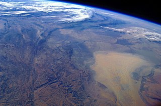
The Amu Darya is a major river in Central Asia and Afghanistan. Rising in the Pamir Mountains, north of the Hindu Kush, the Amu Darya is formed by the confluence of the Vakhsh and Panj rivers, in the Tigrovaya Balka Nature Reserve on the border between Afghanistan and Tajikistan, and flows from there north-westwards into the southern remnants of the Aral Sea. In its upper course, the river forms part of Afghanistan's northern border with Tajikistan, Uzbekistan, and Turkmenistan. In ancient history, the river was regarded as the boundary of Greater Iran with "Turan", which roughly corresponded to present-day Central Asia. The Amu Darya has a flow of about 70 cubic kilometres per year on average.
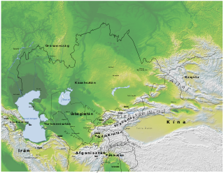
Turkmenistan is a landlocked country in Central Asia, bordering the Caspian Sea to the west, Iran and Afghanistan to the south, Uzbekistan to the north-east, and Kazakhstan to the north-west. It is the southernmost republic of the Commonwealth of Independent States (CIS), the loose federation created at the end of 1991 by most of the Post-Soviet states.

The Aral Sea was an endorheic lake lying between Kazakhstan in the north and Uzbekistan in the south which began shrinking in the 1960s and had largely dried up by the 2010s. The name roughly translates as "Sea of Islands", referring to over 1,100 islands that had dotted its waters. In the Mongolic and Turkic languages, aral means "island, archipelago". The Aral Sea drainage basin encompasses Uzbekistan and parts of Tajikistan, Turkmenistan, Kyrgyzstan, Kazakhstan, Afghanistan, and Iran.

The Syr Darya, historically known as the Jaxartes, is a river in Central Asia. The name, which is Persian, literally means Syr Sea or Syr River. It originates in the Tian Shan Mountains in Kyrgyzstan and eastern Uzbekistan and flows for 2,256.25 kilometres (1,401.97 mi) west and north-west through Uzbekistan and southern Kazakhstan to the northern remnants of the Aral Sea. It is the northern and eastern of the two main rivers in the endorheic basin of the Aral Sea, the other being the Amu Darya (Jayhun).

The Karakum Desert, also spelled Kara-Kum and Gara-Gum, is a desert in Central Asia. Its name in Turkic languages means "black sand": "kum" means sand; "kara" is a contraction of garaňky: "dark" or may pre-date that in this language family. This refers to the shale-rich sand generally beneath the sand of much of the desert. It occupies about 70 percent, 350,000 km2 (140,000 sq mi), of Turkmenistan.
Karakalpakstan, officially the Republic of Karakalpakstan, is an autonomous republic of Uzbekistan. It occupies the whole northwestern part of Uzbekistan. The capital is Nukus. The Republic of Karakalpakstan has an area of 166,590 km2 (64,320 sq mi), and a population of about two million. Its territory covers the classical land of Khwarezm, which in classical Persian literature was known as Kāt (کات).
The Massagetae or Massageteans, also known as Sakā tigraxaudā or Orthocorybantians, were an ancient Eastern Iranian Saka people who inhabited the steppes of Central Asia and were part of the wider Scythian cultures.

The Caspian tiger was a Panthera tigris tigris population native to eastern Turkey, northern Iran, Mesopotamia, the Caucasus around the Caspian Sea, Central Asia to northern Afghanistan, and the Xinjiang region in western China. Until the Middle Ages, it was also present in Ukraine and southern Russia. It inhabited sparse forests and riverine corridors in this region until the 1970s. This population was regarded as a distinct subspecies and assessed as extinct in 2003.

Konye-Urgench, also known as Old Urgench or Urganj, is a city of about 30,000 inhabitants in north Turkmenistan, just south from its border with Uzbekistan. It is the site of the ancient town of Gurgānj, which contains the ruins of the capital of Khwarazm. Its inhabitants deserted the town in the early eighteenth century in order to develop a new settlement, and Konye-Urgench has remained undisturbed ever since. In 2005, the ruins of Old Urgench were inscribed on the UNESCO List of World Heritage Sites.

The Karakum Canal in Turkmenistan is one of the largest irrigation and water supply canals in the world. Started in 1954, and completed in 1988, it is navigable over much of its 1,375-kilometre (854 mi) length, and carries 13 cubic kilometres (3.1 cu mi) of water annually from the Amu-Darya River across the Karakum Desert in Turkmenistan. The canal opened up huge new tracts of land to agriculture, especially to cotton monoculture heavily promoted by the Soviet Union, and supplying Ashgabat with a major source of water. The canal is also a major factor leading to the Aral Sea environmental disaster. The Soviet regime planned to at some time extend the canal to the Caspian Sea.

The Sarygamysh Lake, also Sarykamysh or Sary-Kamysh, is a lake in Central Asia. It is about midway between the Caspian Sea and the Aral Sea. It is the largest lake in Turkmenistan, in which three quarters of the entire lake's area is located. The Sarykamysh basin and the Sarykamysh delta of the Amu Darya river are physical and geographical nature regions of the Dashoguz Region of Turkmenistan.

The Khanate of Khiva was a Central Asian polity that existed in the historical region of Khwarezm in Central Asia from 1511 to 1920, except for a period of Afsharid occupation by Nader Shah between 1740 and 1746. Centred in the irrigated plains of the lower Amu Darya, south of the Aral Sea, with the capital in the city of Khiva, the country was ruled by a Turco-Mongol tribe, the Khongirads, who came from Astrakhan. It covered present western Uzbekistan, southwestern Kazakhstan and much of Turkmenistan before Russian arrival at the second half of the 19th century.

The Aydar Lake is part of the man-made Aydar-Arnasay system of lakes, which covers 4,000 square kilometres (1,500 mi2). This has 3 brackish water lakes, deep basins of the south-eastern Kyzyl Kum. The lakes are expansive reservoirs of Soviet planning.
Oxiana is the region surrounding the Amu Darya River which flows along Afghanistan's northern border separating it from Tajikistan and Uzbekistan before turning northwest into Turkmenistan to the Aral Sea. In ancient times, the river was known as the Oxus in Greek.

The South Aral Sea was a lake in the basin of the former Aral Sea which formed in 1987 when that body divided in two, due to diversion of river inflow for agriculture. In 2003, the South Aral Sea itself split into eastern and western basins, the Eastern Sea and the West Aral Sea, connected by a narrow channel that balanced surface levels but did not allow mixing, and in 2005 the North Aral Sea was dammed to prevent the collapse of its fisheries, cutting off the only remaining inflow to the southern lakes. In 2008, the Eastern Sea split again, and in May 2009 had almost completely dried out, leaving only the small permanent Barsakelmes Lake between the Northern and Western Seas and increasing the expanse of the Aralkum desert. In 2010, it was partially filled again by meltwater, and by 2014 was once again dry. The West Aral Sea has some replenishment from groundwater in the northwest, and so is likely to avoid desiccation.
Protected areas of Turkmenistan include nine nature reserves (zapovednik) and 13 sanctuaries (zakaznik) with a total area of 19,750 km2 or more than 4% of Turkmenistan's territory.

The Main Turkmen Canal was a large-scale irrigation project in the Turkmen Soviet Socialist Republic. The canal was intended to transport water from the Amu Darya river to Krasnovodsk, a city in Turkmenistan on the coast of the Caspian Sea. The canal was going to use the course of the ancient dry Uzboy River bed.

In the Russo–Khivan War of 1873, Russia conquered the Khanate of Khiva, and it became a Russian protectorate.

The Central Asian riparian woodlands ecoregion is spread out across the deserts and plains of central Asia between the Aral Sea and the mountains 2,000 kilometres (1,200 mi) to the east. The long narrow components of the ecoregion follow the large rivers fed by snowmelt, and provide critical habitat for migratory birds as they travel through the arid region. The vegetation is referred to as tugai, characterized by low tangles of trees and brush along the edges of the rivers and associated wetlands, and fed by groundwater instead of precipitation.


