Vaalwater | |
|---|---|
 R33 in Vaalwater | |
 Vaalwater  Vaalwater | |
| Coordinates: 24°17′S28°6′E / 24.283°S 28.100°E | |
| Country | South Africa |
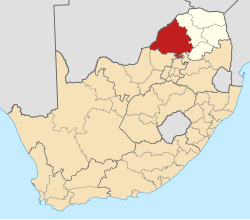
| Province | Limpopo |
| District | Waterberg |
| Municipality | Modimolle–Mookgophong |
| Area | |
• Total | 10.51 km2 (4.06 sq mi) |
| Population (2011) [1] | |
• Total | 3,964 |
| • Density | 377.2/km2 (976.9/sq mi) |
| Racial makeup (2011) | |
| • Black African | 87.4% |
| • Coloured | 0% |
| • Indian | 0.25% |
| • White | 12% |
| First languages (2011) | |
| • Sepedi | 64.3% |
| • Afrikaans | 11.3% |
| • Tsonga | 7,9% |
| Time zone | UTC+2 (SAST) |
| PO box | 8888 |
| Area code | 014 |
Vaalwater is a small town situated on the Mokolo River in the Limpopo province of South Africa.