
Mountrail County is a county in the northwestern part of North Dakota, United States. As of the 2020 census, the population was 9,809. Its county seat is Stanley. The county was originally created in 1873, then removed in 1892, annexed by Ward County. It was re-created and organized in 1909. The county is home to the headquarters of the Three Affiliated Tribes of the Mandan, Hidatsa, and Arikara people, and a large part of the county belongs to the tribe's Fort Berthold reservation.
Mercer County is a county in the U.S. state of North Dakota. As of the 2020 census, the population was 8,350. Its county seat is Stanton.

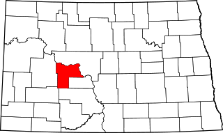
McLean County is a county in the U.S. state of North Dakota. As of the 2020 census, the population was 9,771. Its county seat is Washburn.

McKenzie County is a county in the U.S. state of North Dakota. As of the 2020 census, the population was 14,704. Its county seat is Watford City.

Kidder County is a county located in the U.S. state of North Dakota. As of the 2020 census, the population was 2,394. Its county seat is Steele.
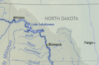
Lake Sakakawea is a large reservoir in the north central United States, impounded in 1953 by Garrison Dam, a U.S. Army Corps of Engineers dam located in the Missouri River basin in central North Dakota. Named for the Shoshone-Hidatsa woman Sacagawea, it is the largest man-made lake located entirely within North Dakota, the second largest in the United States by area after Lake Oahe, and the third largest in the United States by volume, after Lake Mead and Lake Powell.

Garrison Dam is an earth-fill embankment dam on the Missouri River in central North Dakota, U.S. Constructed by the U.S. Army Corps of Engineers from 1947 to 1953, at over two miles (3.2 km) in length, the dam is the fifth-largest earthen dam in the world. The reservoir impounded by the dam is Lake Sakakawea, which extends to Williston and the confluence with the Yellowstone River, near the Montana border. The dam and resulting reservoir inundated approximately one-sixth (16.6%) to one-fourth (25%) of Fort Berthold Indian Reservation's land, resulting in the loss of homes, farmland, and community infrastructure for the Three Affiliated Tribes.

The Fort Berthold Indian Reservation is a U.S. Indian reservation in western North Dakota that is home for the federally recognized Mandan, Hidatsa, and Arikara Nation, also known as the Three Affiliated Tribes. The reservation includes lands on both sides of the Missouri River. The tribal headquarters is in New Town, the 18th largest city in North Dakota.

Van Hook is a thriving resort community built on the shores of Lake Sakakawea. The town was disbanded in the 1950s with the flooding of Lake Sakakawea and for a very short period of time was classified as a ghost town in the north central United States, located in Van Hook Township in Mountrail County, North Dakota. The original town site was mostly left not flooded when Lake Sakakawea was formed in the 1950s behind Garrison Dam.
Verendrye National Monument was a federally protected area in the U.S. state of North Dakota from 1917 to 1956. In the latter year it was withdrawn as a national monument. It is located in southwestern Mountrail County, west of the city of New Town. It lies within the Fort Berthold Indian Reservation.
Edna Township is a civil township in Barnes County in the U.S. state of North Dakota. As of the 2000 Census, its population was 74. It is the 20th largest township in the county in terms of both total population and population density.
Dakota Lake National Wildlife Refuge is a National Wildlife Refuge in North Dakota. It is managed under Kulm Wetland Management District.
Lambs Lake National Wildlife Refuge is a National Wildlife Refuge in Nelson County, North Dakota. It is managed under Devils Lake Wetland Management District. This is a limited-interest national wildlife refuge. The FWS has an easement on private property allowing it to manage wildlife habitat, but the land remains private property. There is no public access although wildlife may be observed from adjacent public roads. Limited-interest refuges were created in the 1930s and 1940s in response to declining waterfowl populations and the need to get people back to work during the Great Depression. Many landowners sold easements allowing the federal government to regulate water levels and restrict hunting.
Little Goose National Wildlife Refuge is a National Wildlife Refuge in Grand Forks County, North Dakota. It is managed under the Devils Lake Wetland Management District.
Rock Lake National Wildlife Refuge is a National Wildlife Refuge in Towner County, North Dakota. It is managed under Devils Lake Wetland Management District.
Snyder Lake National Wildlife Refuge is a National Wildlife Refuge in Towner County, North Dakota. It is managed under Devils Lake Wetland Management District.
Wood Lake National Wildlife Refuge is a National Wildlife Refuge in Benson County, North Dakota. It is managed under Devils Lake Wetland Management District.
Stump Lake National Wildlife Refuge is a National Wildlife Refuge in Nelson County, North Dakota. It is managed under Devils Lake Wetland Management District.
Van Hook Township is a township in Mountrail County in the U.S. state of North Dakota. At the time of the 2000 Census, its population was 42, and estimated to be 41 as of 2009.

Lake Sakakawea State Park is a public recreation area occupying 739 acres (299 ha) on the southern shore of Lake Sakakawea in Mercer County, North Dakota. The state park is located adjacent to the Garrison Dam, one mile (1.6 km) north of Pick City.
