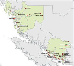
Vancouver Coastal Health

Last updated
Vancouver Coastal Health
Formation2001
TypeBritish Columbia Health Authority
President & Chief Executive Officer
Vivian Eliopoulos [1]
Key people
Bob Chapman, Michelle de Moor, Gail Malenstyn, Darlene MacKinnon, Leslie Bonshor, Charlene Chiang, Fernando Pica, Darcia Pope, Wayne Balshin, Lorraine Blackburn, Dr. Patricia Daly, Yasmin Jetha, Jo-Ann Tait
Budget
$3.2 billion (CDN) (approx)
Staff
29,000 staff and medical staff (approx), 3,000 volunteers (approx), 900 researchers (approx)
Website www.vch.ca

Vancouver Coastal Health (VCH) is a regional health authority that provides health services including primary, secondary, tertiary and quaternary care, home and community care, mental health services, population and preventive health and addictions services in part of Greater Vancouver and the Coast Garibaldi area.

Contents

VCH is one of five publicly funded regional healthcare authorities [2] within the Canadian province of British Columbia. The government of British Columbia, through the British Columbia Ministry of Health, sets province-wide goals, standards and performance agreements for health service delivery by the seven health authorities.

Service area

Vancouver Coastal Health Authority serves the 1.25 million of British Columbia's population of five million (approximately one in four) who live in a geographic area of 58,560 square kilometres (22,610 sq mi) that includes 12 municipalities, four regional districts and 14 Aboriginal communities. VCH is geographically divided into three health service delivery areas (HSDA), which in turn are divided into 14 local health areas (LHA). [3]

The following regional districts are partially or entirely covered by VCHA.

Health services provided

Public healthPrimary careAcute careHome & community servicesMental health & addictions
  • Environmental health protection:
    • Food & water safety
  • Disease surveillance & control:
    • Immunization
    • HIV/AIDS programs
  • Children & youth services
  • Primary care clinics
  • Aboriginal services:
    • Health & wellness
    • Addiction & treatment
    • Community health
  • Hospital inpatient care
  • Surgery specialties & subspecialities
  • Complex medical surgery (tertiary & quaternary)
  • Acute and specialized rehab
  • Urgent care
  • Same-day care
  • Ambulatory care
  • Community services
    • Assisted living
    • Home care
    • Occupational therapy & physiotherapy
    • Adult day care
  • Residential services
    • Complex care
    • Hospice care
    • Transitional care
  • Community Development
  • Housing
  • Emergency & urgent services
  • Residential & community services
  • Addictions
    • Needle exchange
    • Supervised injection site
    • Free safer supplies [4]

Related Research Articles

<span class="mw-page-title-main">Lower Mainland</span> Region in British Columbia, Canada

The Lower Mainland is a geographic and cultural region of the mainland coast of British Columbia that generally comprises the regional districts of Metro Vancouver and the Fraser Valley. Home to approximately 3.05 million people as of the 2021 Canadian census, the Lower Mainland contains sixteen of the province's 30 most populous municipalities and approximately 60% of the province's total population.

Lillooet is a town in the Fraser Canyon in British Columbia.

Highway 99 is a provincial highway in British Columbia that runs 377 kilometres (234 mi) from the U.S. border to near Cache Creek, serving Greater Vancouver and the Squamish–Lillooet corridor. It is a major north–south artery within Vancouver and connects the city to several suburbs as well as the U.S. border, where it continues south as Interstate 5. The central section of the route, also known as the Sea to Sky Highway, serves the communities of Squamish, Whistler, and Pemberton. Highway 99 continues through Lillooet and ends at a junction with Highway 97 near Cache Creek.

<span class="mw-page-title-main">Greater Vancouver</span> Metropolitan area in British Columbia, Canada

Greater Vancouver, also known as Metro Vancouver, is the metropolitan area with its major urban centre being the city of Vancouver, British Columbia, Canada. The term "Greater Vancouver" describes an area that is roughly coterminous with the region governed by the Metro Vancouver Regional District (MVRD), though it predates the 1966 creation of the regional district. It is often used to include areas beyond the boundaries of the regional district but does not generally include wilderness and agricultural areas that are included within the MVRD.

<span class="mw-page-title-main">Sunshine Coast Regional District</span> Regional district in British Columbia, Canada

The Sunshine Coast Regional District is a regional district in British Columbia, Canada. It is located on the southern mainland coast, across Georgia Strait from Vancouver Island. It borders on the qathet Regional District to the north, the Squamish-Lillooet Regional District to the east, and, across Howe Sound, the Metro Vancouver District to the south. The regional district offices are located in the District Municipality of Sechelt.

<span class="mw-page-title-main">Pacific Coastal Airlines</span> Canadian regional airline servicing British Columbia

Pacific Coastal Airlines is a Canadian regional airline that operates scheduled, charter and cargo services to destinations in British Columbia. Its head office is located in the South Terminal of Vancouver International Airport in Richmond, British Columbia. Its main base is Vancouver International Airport.

BC Transit is a provincial crown corporation responsible for coordinating the delivery of public transportation within British Columbia, Canada, outside Greater Vancouver. BC Transit is headquartered in Victoria, British Columbia. In 2022, the system had a ridership of 22,487,400, or about 103,000 per weekday as of the third quarter of 2023.

<span class="mw-page-title-main">Bella Coola, British Columbia</span> Town in British Columbia, Canada

Bella Coola is a unincorporated community in the Bella Coola Valley of British Columbia, Canada. Bella Coola usually refers to the entire valley, encompassing the settlements of Bella Coola proper, Lower Bella Coola, Hagensborg, Salloompt, Nusatsum, Firvale, and Stuie. It is also the location of the head offices of the Central Coast Regional District.

<span class="mw-page-title-main">Geography of British Columbia</span>

British Columbia is the westernmost province of Canada, bordered by the Pacific Ocean. With an area of 944,735 km2 (364,764 sq mi) it is Canada's third-largest province. The province is almost four times the size of the United Kingdom and larger than every United States state except Alaska. It is bounded on the northwest by the U.S. state of Alaska, directly north by Yukon and the Northwest Territories, on the east by Alberta, and on the south by the U.S. states of Washington, Idaho, and Montana. Formerly part of the British Empire, the southern border of British Columbia was established by the 1846 Oregon Treaty. The province is dominated by mountain ranges, among them the Canadian Rockies but dominantly the Coast Mountains, Cassiar Mountains, and the Columbia Mountains. Most of the population is concentrated on the Pacific coast, notably in the area of Vancouver, located on the southwestern tip of the mainland, which is known as the Lower Mainland. It is the most mountainous province of Canada.

<span class="mw-page-title-main">Pacific Ranges</span> Subrange of the Coast Mountains in British Columbia, Canada

The Pacific Ranges are the southernmost subdivision of the Coast Mountains portion of the Pacific Cordillera. Located entirely within British Columbia, Canada, they run northwest from the lower stretches of the Fraser River to Bella Coola and Burke Channel, north of which are the Kitimat Ranges. The Coast Mountains lie between the Interior Plateau and the Coast of British Columbia.

<span class="mw-page-title-main">British Columbia Coast</span> Coastal region of British Columbia, Canada

The British Columbia Coast, popularly referred to as the BC Coast or simply the Coast, is a geographic region of the Canadian province of British Columbia. As the entire western continental coastline of Canada along the Pacific Ocean is in the province, it is synonymous with being the West Coast of Canada.

The Bella Coola River is a major river on the Pacific slope of the Coast Mountains in southern British Columbia. The town of Bella Coola is at its mouth on North Bentinck Arm. Bella Coola Indian Reserve No. 1 the location of the main community today of the surviving population of the Nuxalk who gathered there after depredations by smallpox and colonialization.

Paul St. Pierre was a journalist and author in British Columbia, Canada. He was the Member of Parliament for the riding of Coast Chilcotin from 1968 to 1972. He was defeated in the 1972 election by New Democratic Party candidate Harry Olaussen in a tight three-way race. He was especially known for his popular fiction recounting adventures and quirks of life in the Chilcotin-Cariboo, and for a regular column that appeared for many years in the Vancouver Sun.

<span class="mw-page-title-main">Hagensborg</span> Community in the country of Canada

Hagensborg, originally named Kristiania, is a small community in the Bella Coola Valley in British Columbia, Canada. Its census population in 2006 was 248.

Emergency Support Services (ESS) is a component of Emergency Management British Columbia. As of March 2023, EMBC became part of the B.C. Ministry of Emergency Management and Climate Readiness ESS are those services required to preserve the well-being of people affected by an emergency or disaster. Teams are established in local municipalities and assemble together for meetings and contingency planning.

<span class="mw-page-title-main">Island Health</span> Public health authority in Vancouver, British Columbia, Canada

Island Health, also known as the Vancouver Island Health Authority, is the publicly funded health care provider in the southwestern portion of the Canadian province of British Columbia. It was established as one of five geographically based health authorities in 2001 by the Government of British Columbia.

<span class="mw-page-title-main">British Columbia Interior</span> Interior region of British Columbia, Canada

The British Columbia Interior, popularly referred to as the BC Interior or simply the Interior, is a geographic region of the Canadian province of British Columbia. While the exact boundaries are variously defined, the British Columbia Interior is generally defined to include the 14 regional districts that do not have coastline along the Pacific Ocean or Salish Sea, and are not part of the Lower Mainland. Other boundaries may exclude parts of or even entire regional districts, or expand the definition to include the regional districts of Fraser Valley, Squamish–Lillooet, and Kitimat–Stikine.

References

  1. "Senior Executive Team".
  2. "Regional Health Authorities". gov.bc.ca. Government of British Columbia. Retrieved 21 March 2020.
  3. "Health Boundaries - Province of British Columbia".
  4. "Vancouver Coastal Health to hand out $50,000 worth of crack pipes.", Vancouver Sun