 | |
| Current series | |
|---|---|
| Slogan | HAFA ADAI |
| Introduced | 2005 |
| History | |
| First issued | 1968 |
The U.S. commonwealth of the Northern Mariana Islands first required its residents to register their motor vehicles and display license plates in 1968. [1]
| | |
| Current series | |
|---|---|
| Slogan | HAFA ADAI |
| Introduced | 2005 |
| History | |
| First issued | 1968 |
The U.S. commonwealth of the Northern Mariana Islands first required its residents to register their motor vehicles and display license plates in 1968. [1]
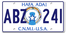
Since 1989, all passenger plates have featured a round mounting hole at the top right and horizontal slots in the other three corners, as with plates of Hawaii and Guam.
| Image | First issued | Design | Slogan | Serial format | Serials issued | Notes |
|---|---|---|---|---|---|---|
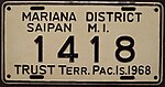 | 1968 | |||||
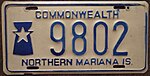 | 1978 | |||||
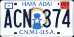 | 1989 | Dark blue embossed serials on reflective white, with motto centered at top, "C.N.M.I.-U.S.A." centered at the bottom, and the CNMI's seal in the center. [2] | "HAFA ADAI" centered at top, in blue. | ABC 123 | AAA 000 to present | Above is original 1988 base (notice lack of MO./YR. markings in upper boxes. Below is later version with indications for month and year stickers. |
 | 2005 | As above, but with serials surface-printed instead of embossed (by at least the ADA series). [2] | ||||

The Mariana Trench is an oceanic trench located in the western Pacific Ocean, about 200 kilometres (124 mi) east of the Mariana Islands; it is the deepest oceanic trench on Earth. It is crescent-shaped and measures about 2,550 km (1,580 mi) in length and 69 km (43 mi) in width. The maximum known depth is 10,984 ± 25 metres at the southern end of a small slot-shaped valley in its floor known as the Challenger Deep. The deepest point of the trench is more than 2 km (1.2 mi) farther from sea level than the peak of Mount Everest.

The Northern Mariana Islands, officially the Commonwealth of the Northern Mariana Islands, is an unincorporated territory and commonwealth of the United States consisting of 14 islands in the northwestern Pacific Ocean. The CNMI includes the 14 northernmost islands in the Mariana Archipelago; the southernmost island, Guam, is a separate U.S. territory. The Northern Mariana Islands were listed by the United Nations as a non-self governing territory until 1990.

Saipan is the largest island and capital of the Northern Mariana Islands, a commonwealth of the United States in the western Pacific Ocean. According to 2020 estimates by the United States Census Bureau, the population of Saipan was 43,385, a decline of 10% from its 2010 count of 48,220.
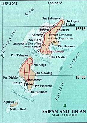
Tinian is one of the three principal islands of the Commonwealth of the Northern Mariana Islands. Together with uninhabited neighboring Aguiguan, it forms Tinian Municipality, one of the four constituent municipalities of the Northern Marianas. Tinian's largest village is San Jose. Tinian is just south of the most inhabited island Saipan, but north of the populated Rota to the south. The island is home to many WW2 historical sites, cattle ranches, and beaches. There was a 5-star casino that operated from 1998 to 2016; remaining are other hotels/resorts and a golf course. The main access to Saipan is by a short airplane ride from the international airport, or by a charter boat.

The Mariana Islands, also simply the Marianas, are a crescent-shaped archipelago comprising the summits of fourteen longitudinally oriented, mostly dormant volcanic mountains in the northwestern Pacific Ocean, between the 12th and 21st parallels north and along the 145th meridian east. They lie south-southeast of Japan, west-southwest of Hawaii, north of New Guinea and east of the Philippines, demarcating the Philippine Sea's eastern limit. They are found in the northern part of the western Oceanic sub-region of Micronesia, and are politically divided into two jurisdictions of the United States: the Commonwealth of the Northern Mariana Islands and, at the southern end of the chain, the territory of Guam. The islands were named after the influential Spanish queen Mariana of Austria following their colonization in the 17th century.
The flag of the Commonwealth of the Northern Mariana Islands was adopted in July 1985 by the Second Northern Marianas Constitution. The NMI flag was originally designed during the year 1985. Later during that year, they finalized the draft of the flag in the last CNMI constitutional convention. This was the most symbolic moment of the annexation of the CNMI.

The Philippine Sea Plate or the Philippine Plate is a tectonic plate comprising oceanic lithosphere that lies beneath the Philippine Sea, to the east of the Philippines. Most segments of the Philippines, including northern Luzon, are part of the Philippine Mobile Belt, which is geologically and tectonically separate from the Philippine Sea Plate.
U.S. states, districts, and territories have representative symbols that are recognized by their state legislatures, territorial legislatures, or tradition. Some, such as flags, seals, and birds have been created or chosen by all U.S. polities, while others, such as state crustaceans, state mushrooms, and state toys have been chosen by only a few.

The District Court for the Northern Mariana Islands is a federal territorial court whose jurisdiction comprises the United States-affiliated Commonwealth of the Northern Mariana Islands (CNMI). It was established by Act of Congress in 1977, pursuant to an international agreement between the United States and the CNMI that brought the CNMI under United States sovereignty. The court began hearing cases in January 1978. The court regularly sits in Saipan but may sit elsewhere in the CNMI. The court has the same jurisdiction as United States district courts, including diversity jurisdiction and bankruptcy jurisdiction. However, the District Court is not an Article III U.S. District Court, and because of that its judge is appointed for a 10-year term instead of for life. Appeals are taken to the Ninth Circuit.
The Democratic Party of the Northern Mariana Islands is a political party in the Northern Mariana Islands. It began as a purely local territorial party and is now officially affiliated with the United States' national Democratic Party.
The CNMI Republican Party is a political party in the Northern Mariana Islands. The Northern Mariana Islands Republican Party is now associated with the United States Republican Party though no Northern Mariana Islands politicians have achieved high-ranking positions in the mainland United States.

The U.S. unincorporated territory of Guam first required its residents to register their motor vehicles and display license plates in 1916.

The Federated States of Micronesia requires its residents to register their motor vehicles and display vehicle registration plates. Current plates are North American standard 6 × 12 inches.

The Mariana Plate is a micro tectonic plate located west of the Mariana Trench which forms the basement of the Mariana Islands which form part of the Izu–Bonin–Mariana Arc. It is separated from the Philippine Sea Plate to the west by a divergent boundary with numerous transform fault offsets. The boundary between the Mariana and the Pacific Plate to the east is a subduction zone with the Pacific Plate subducting beneath the Mariana. This eastern subduction is divided into the Mariana Trench, which forms the southeastern boundary, and the Izu–Ogasawara Trench the northeastern boundary. The subduction plate motion is responsible for the shape of the Mariana plate and back arc.
Sinapalo or Sinapalu is a village on the island of Rota in the Northern Mariana Islands. The village is the largest settlement on the island, located south of the island's airport, Rota International Airport, close to the center of the island.

Kagman High School (KHS) is one of three public high schools on Saipan, Northern Mariana Islands. It is located in Kagman, is part of the Commonwealth of the Northern Mariana Islands Public School System and opened in January 2002. KHS serves about 645 students from the villages of Kagman, north to Capitol Hill, and all the way through to Marpi.

Gun laws in the Northern Mariana Islands regulate the sale, possession, and use of firearms and ammunition in the Commonwealth of the Northern Mariana Islands. As the Northern Mariana Islands is a commonwealth of the United States, many federal laws apply, as well as Constitutional rulings and protections.
Same-sex marriage was legalized in the Northern Mariana Islands by the U.S. Supreme Court's landmark ruling in Obergefell v. Hodges on June 26, 2015, which struck down same-sex marriage bans nationwide. On June 29, Governor Eloy Inos issued a statement hailing the decision as "historic", and said he would work with the Attorney General and local officials to bring the U.S. territory into compliance. Attorney General Edward Manibusan issued a memorandum on June 30 confirming that the territory was bound by the court decision and said that marriage license forms would be changed to include same-sex couples.

The Bahamas requires its residents to register their motor vehicles and display a vehicle registration plate. Current plates are North American standard 6 × 12 inches. The configuration of the plates is two letters followed by four numbers. At the bottom of the plate it's shown the flag of the Bahamas.
| | This article about an automotive part or component is a stub. You can help Wikipedia by expanding it. |
| | This Northern Marianas-related article is a stub. You can help Wikipedia by expanding it. |