Related Research Articles
La Crescenta-Montrose is an unincorporated area in Los Angeles County, California, United States. The community is bordered by Glendale to the south and west, La Cañada Flintridge to the east, and Angeles National Forest to the north. According to the United States Census Bureau, the La Crescenta-Montrose Census-Designated Place (CDP) measures about 3.4 square miles (8.8 km2), and the population was 19,653 at the 2010 census, up from 18,532 in 2000.

Chatsworth is a suburban neighborhood in the City of Los Angeles, California, in the San Fernando Valley.
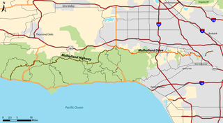
Mulholland Drive is a street and road in the eastern Santa Monica Mountains of Southern California. It is named after pioneering Los Angeles civil engineer William Mulholland. The western rural portion in Los Angeles and Ventura Counties is named Mulholland Highway. The road is featured in a significant number of movies, songs, and novels. David Lynch, who wrote and directed a film named after Mulholland Drive, has said that one can feel "the history of Hollywood" on it. Academy Award–winning actor Jack Nicholson has resided at Mulholland Drive for many years and still lives there today.

Tarzana is a suburban neighborhood in the San Fernando Valley region of Los Angeles, California. Tarzana is on the site of a former ranch owned by author Edgar Rice Burroughs. It is named after Burroughs' fictional jungle hero, Tarzan.

Mount Washington is a historic neighborhood in the San Rafael Hills of Northeast Los Angeles, California. Founded in 1909, it includes the Southwest Museum, the world headquarters of the Self-Realization Fellowship, and Eldred Street, one of the three steepest streets in Los Angeles.
The Los Angeles Westside is an urban region in western Los Angeles County, California. It has no official definition, but sources like LA Weekly and the Mapping L.A. survey of the Los Angeles Times place the region on the western side of the Los Angeles Basin south of the Santa Monica Mountains.

Lake View Terrace is a suburban neighborhood in the San Fernando Valley region of the City of Los Angeles, California.

East Hollywood is a densely populated neighborhood of 78,000+ residents in the central region of Los Angeles, California. It is notable for being the site of Los Angeles City College, Barnsdall Park and a hospital district. There are seven public and five private schools, as well as a branch of the Los Angeles Public Library and three hospitals. Almost two-thirds of the people living there were born outside the United States and 90% were renters. In 2000 the neighborhood had high percentages of never-married people and of single parents.

Glassell Park is a neighborhood of Northeast Los Angeles, California, in the San Rafael Hills.
Central Los Angeles is the historic urban region of the City of Los Angeles, California.

The Verdugo Mountains, also known as the Verdugo Hills or simply The Verdugos, are a small, rugged mountain range of the Transverse Ranges system in Los Angeles County, California. Located just south of the western San Gabriel Mountains, the Verdugo Mountains region incorporates the cities of Glendale, Pasadena, and La Cañada Flintridge; the unincorporated communities of Altadena and La Crescenta-Montrose; as well as the City of Los Angeles neighborhood of Sunland-Tujunga.

Cypress Park is a densely populated neighborhood of 10,000+ residents in Northeast Los Angeles, California. Surrounded by hills on three sides, it sits in the valley created by the Los Angeles River and the Arroyo Seco. It is the site of the Rio de Los Angeles State Park, the Los Angeles River Bike Path and other recreational facilities. It hosts one private and four public schools.
Rancho La Cañada was a 5,832-acre (23.60 km2) Mexican land grant in the San Rafael Hills and Crescenta Valley, of present-day Los Angeles County, California given in 1843 by Governor Manuel Micheltorena to a Mexican schoolteacher from Los Angeles, Ygnacio Coronel.
Rancho San Rafael was a 36,403-acre (147.32 km2) Spanish land grant in the San Rafael Hills, bordering the Los Angeles River and the Arroyo Seco in present-day Los Angeles County, southern California, given in 1784 to Jose Maria Verdugo.

Northeast Los Angeles is a 17.18 sq mi (44.5 km2) region of Los Angeles County, comprising seven neighborhoods within the City of Los Angeles. The area is home to Occidental College located in Eagle Rock.
Glenoaks Boulevard is a major thoroughfare in Los Angeles County, which stretches some 22.4 miles as a north-south thoroughfare in Sylmar at its intersection with Foothill Boulevard to a west-east thoroughfare in Glendale before ending in the Scholl Canyon area as a minor street. It passes through much of the San Fernando Valley including San Fernando, Pacoima, and Sun Valley. It is also a north-south thoroughfare in Burbank. Glenoaks Boulevard runs east of and parallel to Interstate 5 in San Fernando and Burbank, and north of and parallel to State Route 134 in Glendale.

Sunland-Tujunga is a Los Angeles City neighborhood within the San Fernando Valley and Verdugo Mountains. Sunland and Tujunga began as separate settlements and today are linked through a single police station, branch library, neighborhood council, chamber of commerce, city council district, and high school. The merging of these communities under a hyphenated name goes back as far as 1928. Sunland-Tujunga contains the highest point of the city, Mount Lukens.

Hollywood Hills West is a neighborhood within Central Los Angeles, California. There are three city parks and one elementary school.

Beverly Grove is a neighborhood within the Beverly–Fairfax neighborhood in the Mid-City West area of Los Angeles, California.
The César E. Chávez Learning Academies, also known as Valley Region High School 5, is a public high school of the Los Angeles Unified School District. It is located in the City of San Fernando in the San Fernando Valley region of the Los Angeles metropolitan area, in the US state of California. It is named after César Chávez.