
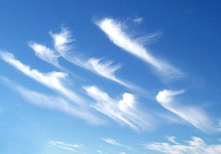
In meteorology, an updraft (British English: up-draught) is a small-scale current of rising air, often within a cloud. [1]
In meteorology, an updraft (British English: up-draught) is a small-scale current of rising air, often within a cloud. [1]
Vertical drafts, known as updrafts or downdrafts, are localized regions of warm or cool air that move vertically. A mass of warm air will typically be less dense than the surrounding region, and so will rise until it reaches air that is either warmer or less dense than itself. The converse will occur for a mass of cool air, and is known as subsidence. This movement of large volumes of air, especially when regions of hot, wet air rise, can create large clouds, and is the central source of thunderstorms. Drafts can also be caused by low or high pressure regions. A low pressure region will attract air from the surrounding area, which will move towards the center and then rise, creating an updraft. A high pressure region will attract air from the surrounding area, which will move towards the center and sink, spawning a downdraft.
Updrafts and downdrafts, along with wind shear in general, are a major contributor to airplane crashes during takeoff and landing in a thunderstorm. Extreme cases, known as downbursts and microbursts, can be deadly and difficult to predict or observe. The crash of Delta Air Lines Flight 191 on its final approach before landing at Dallas/Fort Worth International Airport in 1985 was presumably caused by a microburst, and prompted the Federal Aviation Administration (FAA) to research and deploy new storm detection radar stations at some of the major airports, notably those in the South, Midwest, and Northeast United States where wind shear affects air safety. Downbursts can cause extensive localized damage, similar to that caused by tornadoes. Downburst damage can be differentiated from that of a tornado because the resulting destruction is circular and radiates away from the center. Tornado damage radiates inward, towards the center of the damage.
The term "downdraft" can also refer to a type of backdraft which occurs through chimneys which have fireplaces on the lowermost levels (such as basements) of multi-level buildings. It involves cold air coming down the chimney due to low air pressure, and makes it hard to light fires, and can push soot and carbon monoxide into domiciles.

Cumulonimbus is a dense, towering vertical cloud, typically forming from water vapor condensing in the lower troposphere that builds upward carried by powerful buoyant air currents. Above the lower portions of the cumulonimbus the water vapor becomes ice crystals, such as snow and graupel, the interaction of which can lead to hail and to lightning formation, respectively. When occurring as a thunderstorm these clouds may be referred to as thunderheads. Cumulonimbus can form alone, in clusters, or along squall lines. These clouds are capable of producing lightning and other dangerous severe weather, such as tornadoes, hazardous winds, and large hailstones. Cumulonimbus progress from overdeveloped cumulus congestus clouds and may further develop as part of a supercell. Cumulonimbus is abbreviated Cb.

A thunderstorm, also known as an electrical storm or a lightning storm, is a storm characterized by the presence of lightning and its acoustic effect on the Earth's atmosphere, known as thunder. Relatively weak thunderstorms are sometimes called thundershowers. Thunderstorms occur in a type of cloud known as a cumulonimbus. They are usually accompanied by strong winds and often produce heavy rain and sometimes snow, sleet, or hail, but some thunderstorms produce little precipitation or no precipitation at all. Thunderstorms may line up in a series or become a rainband, known as a squall line. Strong or severe thunderstorms include some of the most dangerous weather phenomena, including large hail, strong winds, and tornadoes. Some of the most persistent severe thunderstorms, known as supercells, rotate as do cyclones. While most thunderstorms move with the mean wind flow through the layer of the troposphere that they occupy, vertical wind shear sometimes causes a deviation in their course at a right angle to the wind shear direction.
Wind shear /ʃɪr/, sometimes referred to as wind gradient, is a difference in wind speed and/or direction over a relatively short distance in the atmosphere. Atmospheric wind shear is normally described as either vertical or horizontal wind shear. Vertical wind shear is a change in wind speed or direction with a change in altitude. Horizontal wind shear is a change in wind speed with a change in lateral position for a given altitude.

A supercell is a thunderstorm characterized by the presence of a mesocyclone, a deep, persistently rotating updraft. Due to this, these storms are sometimes referred to as rotating thunderstorms. Of the four classifications of thunderstorms, supercells are the overall least common and have the potential to be the most severe. Supercells are often isolated from other thunderstorms, and can dominate the local weather up to 32 kilometres (20 mi) away. They tend to last 2–4 hours.

A mesocyclone is a meso-gamma mesoscale region of rotation (vortex), typically around 2 to 6 mi in diameter, most often noticed on radar within thunderstorms. In the northern hemisphere it is usually located in the right rear flank of a supercell, or often on the eastern, or leading, flank of a high-precipitation variety of supercell. The area overlaid by a mesocyclone’s circulation may be several miles (km) wide, but substantially larger than any tornado that may develop within it, and it is within mesocyclones that intense tornadoes form.

A squall is a sudden, sharp increase in wind speed lasting minutes, as opposed to a wind gust, which lasts for only seconds. They are usually associated with active weather, such as rain showers, thunderstorms, or heavy snow. Squalls refer to the increase of the sustained winds over that time interval, as there may be higher gusts during a squall event. They usually occur in a region of strong sinking air or cooling in the mid-atmosphere. These force strong localized upward motions at the leading edge of the region of cooling, which then enhances local downward motions just in its wake.

A squall line, or more accurately a quasi-linear convective system (QLCS), is a line of thunderstorms, often forming along or ahead of a cold front. In the early 20th century, the term was used as a synonym for cold front. Linear thunderstorm structures often contain heavy precipitation, hail, frequent lightning, strong straight-line winds, and occasionally tornadoes or waterspouts. Particularly strong straight-line winds can occur where the linear structure forms into the shape of a bow echo. Tornadoes can occur along waves within a line echo wave pattern (LEWP), where mesoscale low-pressure areas are present. Some bow echoes can grow to become derechos as they move swiftly across a large area. On the back edge of the rainband associated with mature squall lines, a wake low can be present, on very rare occasions associated with a heat burst.

In meteorology, a downburst is a strong downward and outward gushing wind system that emanates from a point source above and blows radially, that is, in straight lines in all directions from the area of impact at surface level. It originates under deep, moist convective conditions like Cumulus congestus or Cumulonimbus. Capable of producing damaging winds, it may sometimes be confused with a tornado, where high-velocity winds circle a central area, and air moves inward and upward. These usually last for seconds to minutes. Downbursts are particularly strong downdrafts within thunderstorms . Downbursts are most often created by an area of significantly precipitation-cooled air that, after reaching the surface (subsiding), spreads out in all directions producing strong winds.
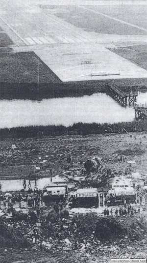
Eastern Air Lines Flight 66 was a regularly scheduled flight from New Orleans to New York City that crashed on June 24, 1975 while on approach to New York's John F. Kennedy International Airport, killing 113 of the 124 people on board. The crash was determined to be caused by wind shear caused by a microburst, but the failure of the airport and the flight crew to recognize the severe weather hazard was also a contributing factor.

An outflow boundary, also known as a gust front, is a storm-scale or mesoscale boundary separating thunderstorm-cooled air (outflow) from the surrounding air; similar in effect to a cold front, with passage marked by a wind shift and usually a drop in temperature and a related pressure jump. Outflow boundaries can persist for 24 hours or more after the thunderstorms that generated them dissipate, and can travel hundreds of kilometers from their area of origin. New thunderstorms often develop along outflow boundaries, especially near the point of intersection with another boundary. Outflow boundaries can be seen either as fine lines on weather radar imagery or else as arcs of low clouds on weather satellite imagery. From the ground, outflow boundaries can be co-located with the appearance of roll clouds and shelf clouds.
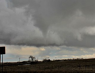
Tornadogenesis is the process by which a tornado forms. There are many types of tornadoes and these vary in methods of formation. Despite ongoing scientific study and high-profile research projects such as VORTEX, tornadogenesis is a volatile process and the intricacies of many of the mechanisms of tornado formation are still poorly understood.

An air-mass thunderstorm, also called an "ordinary", "single cell", "isolated" or "garden variety" thunderstorm, is a thunderstorm that is generally weak and usually not severe. These storms form in environments where at least some amount of Convective Available Potential Energy (CAPE) is present, but with very low levels of wind shear and helicity. The lifting source, which is a crucial factor in thunderstorm development, is usually the result of uneven heating of the surface, though they can be induced by weather fronts and other low-level boundaries associated with wind convergence. The energy needed for these storms to form comes in the form of insolation, or solar radiation. Air-mass thunderstorms do not move quickly, last no longer than an hour, and have the threats of lightning, as well as showery light, moderate, or heavy rainfall. Heavy rainfall can interfere with microwave transmissions within the atmosphere.

Severe weather is any dangerous meteorological phenomenon with the potential to cause damage, serious social disruption, or loss of human life. These vary depending on the latitude, altitude, topography, and atmospheric conditions. High winds, hail, excessive precipitation, and wildfires are forms and effects, as are thunderstorms, downbursts, tornadoes, waterspouts, tropical cyclones, and extratropical cyclones. Regional and seasonal phenomena include blizzards (snowstorms), ice storms, and duststorms.

Atmospheric convection is the result of a parcel-environment instability in the atmosphere. Different lapse rates within dry and moist air masses lead to instability. Mixing of air during the day expands the height of the planetary boundary layer, leading to increased winds, cumulus cloud development, and decreased surface dew points. Convection involving moist air masses leads to thunderstorm development, which is often responsible for severe weather throughout the world. Special threats from thunderstorms include hail, downbursts, and tornadoes.
Convective storm detection is the meteorological observation, and short-term prediction, of deep moist convection (DMC). DMC describes atmospheric conditions producing single or clusters of large vertical extension clouds ranging from cumulus congestus to cumulonimbus, the latter producing thunderstorms associated with lightning and thunder. Those two types of clouds can produce severe weather at the surface and aloft.
The airborne wind shear detection and alert system, fitted in an aircraft, detects and alerts the pilot both visually and aurally of a wind shear condition. A reactive wind shear detection system is activated by the aircraft flying into an area with a wind shear condition of sufficient force to pose a hazard to the aircraft. A predictive wind shear detection system is activated by the presence of a wind shear condition ahead of the aircraft. In 1988, the U.S. Federal Aviation Administration (FAA) mandated that all turbine-powered commercial aircraft must have on-board wind shear detection systems by 1993. Airlines successfully lobbied to have commercial turbo-prop aircraft exempted from this requirement.
The following is a glossary of tornado terms. It includes scientific as well as selected informal terminology.
Numerous accidents have occurred in the vicinity of thunderstorms due to the density of clouds. It is often said that the turbulence can be extreme enough inside a cumulonimbus to tear an aircraft into pieces, and even strong enough to hold a skydiver. However, this kind of accident is relatively rare. Moreover, the turbulence under a thunderstorm can be non-existent and is usually no more than moderate. Most thunderstorm-related crashes occur due to a stall close to the ground when the pilot gets caught by surprise by a thunderstorm-induced wind shift. Moreover, aircraft damage caused by thunderstorms is rarely in the form of structural failure due to turbulence but is typically less severe and the consequence of secondary effects of thunderstorms.

This glossary of meteorology is a list of terms and concepts relevant to meteorology and atmospheric science, their sub-disciplines, and related fields.
Project NIMROD was a meteorological field study of severe thunderstorms and their damaging winds conducted by the National Center for Atmospheric Research (NCAR). It took place in the Greater Chicago area from May 15 to June 30, 1978. Data collected was from single cell thunderstorms as well as mesoscale convective systems, such as bow echoes. Using Doppler weather radars and damage clues on the ground, the team studied mesocyclones, downbursts and gust fronts. NIMROD was the first time that microbursts, very localized strong downdrafts under thunderstorms, were detected; this helped improve airport and public safety by the development of systems like the Terminal Doppler Weather Radar and the Low-level windshear alert system.