
Roman Britain was the territory that became the Roman province of Britannia after the Roman conquest of Britain, consisting of a large part of the island of Great Britain. The occupation lasted from AD 43 to AD 410.
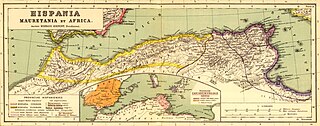
Mauretania is the Latin name for a region in the ancient Maghreb. It extended from central present-day Algeria to the Atlantic, encompassing northern present-day Morocco, and from the Mediterranean in the north to the Atlas Mountains. Its native inhabitants, of Berber ancestry, were known to the Romans as the Mauri and the Masaesyli.
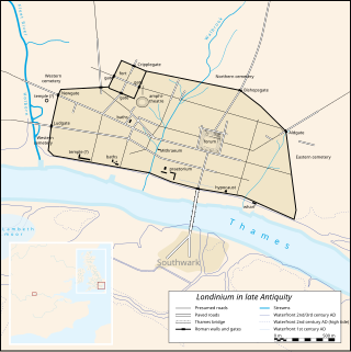
Londinium, also known as Roman London, was the capital of Roman Britain during most of the period of Roman rule. Most twenty-first century historians think that it was originally a settlement established shortly after the Claudian invasion of Britain, on the current site of the City of London around 47–50 AD, but some defend an older view that the city originated in a defensive enclosure constructed during the Claudian invasion in 43 AD. Its earliest securely-dated structure is a timber drain of 47 AD. It sat at a key ford at the River Thames which turned the city into a road nexus and major port, serving as a major commercial centre in Roman Britain until its abandonment during the 5th century.

Roman roads in Britannia were initially designed for military use, created by the Roman army during the nearly four centuries (AD 43–410) that Britannia was a province of the Roman Empire.
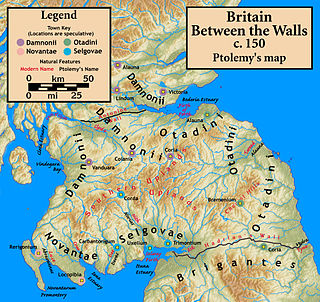
The Votadini, also known as the Uotadini, Wotādīni, Votādīni, or Otadini were a Brittonic people of the Iron Age in Great Britain. Their territory was in what is now south-east Scotland and north-east England, extending from the Firth of Forth and around modern Stirling to the River Tyne, including at its peak what are now the Falkirk, Lothian and Borders regions and Northumberland. This area was briefly part of the Roman province of Britannia. The earliest known capital of the Votadini appears to have been the Traprain Law hill fort in East Lothian, until that was abandoned in the early 5th century. They afterwards moved to Din Eidyn (Edinburgh).

Britannia Superior was a province of Roman Britain created after the civil war between Septimius Severus and Clodius Albinus. Although Herodian credits Severus with dividing Roman Britain into the Northern territory of Britannia Inferior and the Southern territory of Britannia Superior, modern scholarship argues that it is more likely that Caracalla was the person who made the split sometime in the early 3rd century CE. The previous British capital Londinium remained the centre of Britannia Superior while Eboracum, or modern York was the capital of Britannia Inferior. Epigraphical evidence shows that Upper Britain encompassed approximately what is now Wales, southern England and East Anglia. However, the official boundary between Britannia Superior and Inferior is still unclear.
Britannia Prima or Britannia I was one of the provinces of the Diocese of "the Britains" created during the Diocletian Reforms at the end of the 3rd century. It was probably created after the defeat of the usurper Allectus by Constantius Chlorus in AD 296 and was mentioned in the c. 312 Verona List of the Roman provinces. Its position and capital remain uncertain, although it was probably located closer to Rome than Britannia II. At present, most scholars place Britannia I in Wales, Cornwall, and the lands connecting them. On the basis of a recovered inscription, its capital is now usually placed at Corinium of the Dobunni (Cirencester) but some emendations of the list of bishops attending the 315 Council of Arles would place a provincial capital in Isca (Caerleon) or Deva (Chester), which were known legionary bases.
Britannia Secunda or Britannia II was one of the provinces of the Diocese of "the Britains" created during the Diocletian Reforms at the end of the 3rd century. It was probably created after the defeat of the usurper Allectus by Constantius Chlorus in AD 296 and was mentioned in the c. 312 Verona List of the Roman provinces. Its position and capital remain uncertain, although it probably lay further from Rome than Britannia I. At present, most scholars place Britannia II in Yorkshire and northern England. If so, its capital would have been Eboracum (York).
Maxima Caesariensis, also known as Britannia Maxima, was one of the provinces of the Diocese of "the Britains" created during the Diocletian Reforms at the end of the 3rd century. It was probably created after the defeat of the usurper Allectus by Constantius Chlorus in AD 296 and was mentioned in the c. 312 Verona List of the Roman provinces. Its position and capital remain uncertain, although it was probably adjacent to Flavia Caesariensis. On the basis of its governor's eventual consular rank, it is now usually considered to have consisted of Augusta or Londinium (London) and southeastern England.
Flavia Caesariensis, sometimes known as Britannia Flavia, was one of the provinces of the Diocese of "the Britains" created during the Diocletian Reforms at the end of the 3rd century. It was probably created after the defeat of the usurper Allectus by Constantius Chlorus in AD 296 and was mentioned in the c. 312 Verona List of the Roman provinces. It seems to have been named after Chlorus's family and was probably located beside Maxima Caesariensis, but their positions and capitals remain uncertain. At present, most scholars place Flavia Caesariensis in the southern Pennines, possibly reaching the Irish Sea and including the lands of the Iceni. Its capital is sometimes placed at Lindum Colonia (Lincoln).
Valentia was probably one of the Roman provinces of the Diocese of "the Britains" in late Antiquity. Its position, capital, and even existence remain a matter of scholarly debate. It was not mentioned in the Verona List compiled around AD 312 and so was probably formed out of one or more of the other provinces established during the Diocletian Reforms. Some scholars propose Valentia was a new name for the entire diocese, but the List of Offices names it as a consular-rank province along with Maxima Caesariensis and the other equestrian-ranked provinces. Hypotheses for the placement of Valentia include Wales, with its capital at Deva (Chester); Cumbria south of Hadrian's Wall, with its capital at Luguvalium (Carlisle), the lands between the Antonine Wall and Hadrian's Wall, possibly with a capital at Habitancum (Risingham),, although the latter is dismissed by some modern scholars due to the absence of archaeological evidence for a Roman re-occupation of southern Scotland in the fourth century.
The Damnonii were a Brittonic people of the late 2nd century who lived in what became the Kingdom of Strathclyde by the Early Middle Ages, and is now southern Scotland. They are mentioned briefly in Ptolemy's Geography, where he uses both of the terms "Damnonii" and "Damnii" to describe them, and there is no other historical record of them, except arguably by Gildas three centuries later. Their cultural and linguistic affinity is presumed to be Brythonic. However, there is no unbroken historical record, and a partly Pictish origin is not precluded.
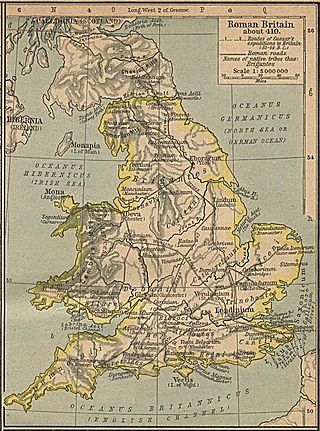
Luguvalium was an ancient Roman city in northern Britain located within present-day Carlisle, Cumbria, and may have been the capital of the 4th-century province of Valentia. It was the northernmost city of the Roman Empire.
Cohors secunda Gallorum veterana equitata was a mixed infantry and cavalry regiment of the Auxilia corps of the Imperial Roman army. It was stationed, in the 2nd and 3rd centuries, in a fort near Hadrian's Wall in Britain.

The Wall of Severus is believed to be a defensive fortification built by the Roman Emperor Septimius Severus during his military campaigns in northern Britannia in the early 3rd century. Although the structure is mentioned in several classical texts, its precise location is academically disputed due to inconsistencies between sources. Scholarly consensus believes they are most likely referring to the Antonine Wall. However, Hadrian's Wall and Offa's Dyke have both been suggested as possible candidates. Archaeological evidence has been discovered showing parts of Offa's Dyke, on the England-Wales border, is at least as old as the mid 5th century, predating the 8th-century reign of the Saxon King Offa of Mercia by 300 years.

Hiberno-Roman relations refers to the relationships which existed between Ireland (Hibernia) and the ancient Roman Empire, which lasted from the 1st century BC to the 5th century AD in Western Europe. Ireland was one of the few areas of western Europe not conquered by Rome.

The frontier of the Roman Empire in Britain is sometimes styled Limes Britannicus by authors for the boundaries, including fortifications and defensive ramparts, that were built to protect Roman Britain. These defences existed from the 1st to the 5th centuries AD and ran through the territory of present-day England, Scotland and Wales.
The Limes Mauretaniae was a portion of a 4,000-kilometre (2,500 mi) Roman fortified border (limes) in Africa approximately 100 kilometres (62 mi) south of the modern day Algiers.

The Baquates were a people living in Mauretania Tingitana under the Roman empire. They are known from Greek and Latin literary sources and inscriptions of the second through fourth centuries AD.
