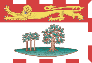
Prince Edward Island is one of the thirteen provinces and territories of Canada. While it is the smallest province in terms of land area and population, it is the most densely populated. The island has several nicknames: "Garden of the Gulf", "Birthplace of Confederation" and "Cradle of Confederation". Its capital and largest city is Charlottetown. It is one of the three Maritime provinces and one of the four Atlantic provinces.

The University of Prince Edward Island (UPEI) is a public university in Charlottetown, Prince Edward Island, Canada, and the only university in the province. Founded in 1969, the enabling legislation is the University Act, R.S.P.E.I 2000.
The Legislative Assembly of Prince Edward Island is the sole chamber of the General Assembly of Prince Edward Island. The Legislative Assembly meets at Province House, which is located at the intersection of Richmond and Great George Streets in Charlottetown. Bills passed by the Assembly are given royal assent by the King of Canada in Right of Prince Edward Island, represented by the lieutenant governor of Prince Edward Island.
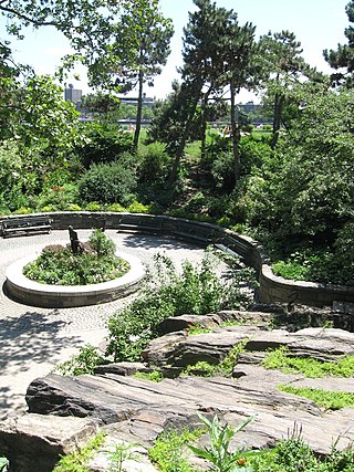
Carl Schurz Park is a 14.9-acre (6.0 ha) public park in the Yorkville neighborhood of Manhattan, New York City, named for German-born Secretary of the Interior Carl Schurz in 1910, at the edge of what was then the solidly German-American community of Yorkville. The park contains Gracie Mansion, the official residence of the Mayor of New York.
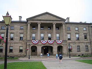
Province House is where the Prince Edward Island Legislature, known as the Legislative Assembly of Prince Edward Island, has met since 1847. The building is located at the intersection of Richmond and Great George Streets in Charlottetown; it is Canada's second-oldest seat of government.

Bagshot Park is a royal residence located near Bagshot, a village 11 miles (18 km) south of Windsor. It is on Bagshot Heath, a 50-square-mile (130 km2) tract of formerly open land in Surrey and Berkshire. Bagshot Park occupies 51 acres (21 ha) within the designated area of Windsor Great Park.
The Charlottetown Driving Park (CDP), located in Charlottetown, Prince Edward Island, Canada is a harness racing track for racing standardbred horses.
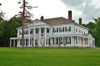
Government House of Prince Edward Island, often referred to as Fanningbank, is the official residence of the lieutenant governor of Prince Edward Island, as well as that in Charlottetown of the Canadian monarch. It stands in the provincial capital at 1 Terry Fox Drive; while the equivalent building in many provinces has a prominent, central place in the capital, the site of Prince Edward Island's Government House is relatively unobtrusive within Charlottetown, giving it more the character of a private home.
RCAF Station Charlottetown was a Royal Canadian Air Force station located in Sherwood, Prince Edward Island. Today's Charlottetown Airport maintains a remnant of the airfield's runways near its general aviation terminal, but all buildings and most infrastructure have been removed.
There are various neighbourhoods within the Canadian city of Charlottetown, Prince Edward Island.

Dalvay-by-the-Sea is a National Historic Site of Canada located on the north shore of Prince Edward Island at the eastern end of Prince Edward Island National Park. The most significant feature of Dalvay is the Queen Anne Revival style hotel, originally constructed as a home for an American industrialist.

Sir William Christopher Macdonald was a Canadian tobacco manufacturer and major education philanthropist in Canada. Though born in Prince Edward island, he is considered a Scots-Quebecer.

By the arrangements of the Canadian federation, the Canadian monarchy operates in Prince Edward Island as the core of the province's Westminster-style parliamentary democracy. As such, the Crown within Prince Edward Island's jurisdiction is referred to as the Crown in Right of Prince Edward Island, His Majesty in Right of Prince Edward Island, or the King in Right of Prince Edward Island. The Constitution Act, 1867, however, leaves many royal duties in Prince Edward Island specifically assigned to the sovereign's viceroy, the lieutenant governor of Prince Edward Island, whose direct participation in governance is limited by the conventional stipulations of constitutional monarchy.

The history of Prince Edward Island covers several historical periods, from the pre-Columbian era to the present day. Prior to the arrival of Europeans, the island formed a part of Mi'kma'ki, the lands of the Mi'kmaq people. The island was first explored by Europeans in the 16th century. The French later laid claim over the entire Maritimes region, including Prince Edward Island in 1604. However, the French did not attempt to settle the island until 1720, with the establishment of the colony of Île Saint-Jean. After peninsular Acadia was captured by the British in 1710, an influx of Acadian migrants moved to areas still under French control, including Île Saint-Jean.
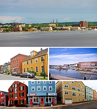
Charlottetown is the capital and largest city of the Canadian province of Prince Edward Island, and the county seat of Queens County. Named after Queen Charlotte, Charlottetown was an unincorporated town until it was incorporated as a city in 1855.

Skmaqn–Port-la-Joye–Fort Amherst is a National Historic Site located in Rocky Point, Prince Edward Island.
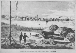
The History of Charlottetown can be traced back to the original French military settlement established on the site in 1720. Over the years Charlottetown has grown to become the largest and most important city on Prince Edward Island.

The Land Question, as it pertains to the history of Prince Edward Island, now in Canada, related to the question of the system of ownership of land on the island. Proprietors, the owners of the land parcels on Prince Edward Island, favoured a system of renting to tenants, but the tenants preferred a system of freehold. In 1767, the British government divided all land in Prince Edward Island into lots to be owned by proprietors, who would collect rent from the settlers, or tenants. Problems soon arose with this scheme, and the low numbers of tenants resulted in proprietors collecting little rent, which in turn led to many proprietors defaulting on their quitrents. An attempt at compulsorily acquiring the land by the Prince Edward Island government from rent defaulters in 1781 resulted in Colonial Office intervention in 1783. In 1786, Governor Walter Patterson, who had set in motion the compulsory acquisition, was removed from office.
Spring Park is a Canadian neighbourhood in the city of Charlottetown, Prince Edward Island.
Old Princetown Road is an historic colonial road in the Canadian province of Prince Edward Island. Dating to at least 1771, the approximately 59-kilometre (37 mi) road was an important inland commercial and military route connecting the town of Princetown or Malpeque with the colonial capital at Charlottetown. A large part of the former road is now in use as Route 2 between Charlottetown and Hunter River, while other parts remain as gravel roads or dirt paths, and some portions have been replaced entirely by farmland. A short section near South Granville is listed on the Canadian Register of Historic Places.

