
The Auckland Harbour Bridge is an eight-lane motorway bridge over the Waitematā Harbour in Auckland, New Zealand. It joins St Marys Bay on the Auckland city side with Northcote on the North Shore side. It is part of State Highway 1 and the Auckland Northern Motorway. The bridge is operated by the NZ Transport Agency (NZTA). It is the second-longest road bridge in New Zealand, and the longest in the North Island.

A reversible lane is a managed lane in which traffic may travel in either direction, depending on certain conditions. Typically, it is meant to improve traffic flow during rush hours, by having overhead traffic lights and lighted street signs notifying drivers which lanes are open or closed to driving or turning.

Māngere Bridge, officially also called the Manukau Harbour Crossing, is a dual motorway bridge over the Manukau Harbour in south-western Auckland, New Zealand, crossing between the suburb also known as Māngere Bridge and the suburb of Onehunga.

State Highway 1 is the longest and most significant road in the New Zealand road network, running the length of both main islands. It appears on road maps as SH 1 and on road signs as a white number 1 on a red shield, but it has the official designations SH 1N in the North Island, SH 1S in the South Island.

The Central Motorway Junction or CMJ, is the intersection of State Highways 1 and 16, just south of the central business district of Auckland. A multilevel structure, it has been described as a "fiendishly complicated, multi-layered puzzle of concrete, steel and asphalt". Carrying around 200,000 vehicles a day, it is one of the busiest stretches of road in New Zealand.

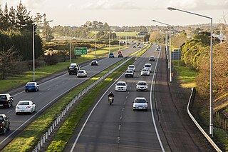
The Northern Busway is a segregated busway that runs along the eastern side of the Northern Motorway, part of State Highway 1, in the north of Auckland, New Zealand, linking the North Shore with the northern end of the Auckland Harbour Bridge. As of May 2022, the busway consists of two-way lanes running between Albany Station and Akoranga Station, and from Akoranga Station a southbound-only lane that joins the harbour bridge approaches just south of the Onewa Road on-ramp system. The busway previously ended at Constellation before an extension to Albany was constructed in 2022.
Transport in Auckland, New Zealand's largest city, is defined by factors that include the shape of the Auckland isthmus, the suburban character of much of the urban area, a history of focusing investment on roading projects rather than public transport, and high car-ownership rates.

The Upper Harbour Bridge is a motorway bridge in west Auckland, New Zealand. It is technically two bridges, spanning the Upper Waitematā Harbour, and connecting Hobsonville and Greenhithe. It is an important connection for State Highway 18, and became even more important as a component of the Western Ring Route when the route was completed on 2 July 2017.

Grafton Gully is a deep and very wide gully running northwards towards the sea through the volcanic hills of the Auckland volcanic field in New Zealand. It divides the CBD from the suburbs of Grafton and Parnell in the east.

The Terrace Tunnel takes the Wellington Urban Motorway (SH1) under The Terrace in central Wellington, New Zealand. Opened in 1978, it is 460 metres in length.

The Auckland Northern Motorway in the Auckland Region of New Zealand links Central Auckland and Warkworth in the former Rodney District via the Hibiscus Coast and North Shore. It is part of State Highway 1.
The Auckland Southern Motorway is the major route south out of the Auckland Region of New Zealand. It is part of State Highway 1.

State Highway 20 (SH 20), also known as the Southwestern Motorway, is a New Zealand state highway linking State Highway 1 at Manukau with State Highway 16 in Point Chevalier, via Māngere and Onehunga. Along with its spurs, State Highway 20A and 20B, the state highway serves Auckland Airport, the country's largest, therefore making SH 20 a key arterial route connecting the airport to the wider Auckland region and most of the upper North Island. The route also forms the southern part of the Western Ring Route, a 48 kilometres (30 mi) motorway route bypassing central Auckland.

The Wynyard Quarter is a reclaimed piece of land on the Waitematā Harbour at the western edge of the Auckland waterfront, New Zealand.

The Newmarket Viaduct is a seven-lane state highway viaduct in Auckland, New Zealand. The 700 m long viaduct, which is up to 20 m high, carries the Southern Motorway over the Newmarket suburb.

The Waterview Connection is a motorway section through west/central Auckland, New Zealand. It connects State Highway 20 in the south at Mt Roskill to State Highway 16 in the west at Point Chevalier, and is a part of the Western Ring Route.

The Victoria Park Tunnel is a motorway tunnel completed in 2012 on New Zealand State Highway 1 in Auckland, New Zealand, taking northbound traffic off the Victoria Park Viaduct, which was converted to all southbound traffic. It lies mostly under Victoria Park.

The Second Harbour Crossing is the name given to the proposed second transport link across the Waitematā Harbour in Auckland, New Zealand. Planners have also referred to new links across the harbour as the Additional Waitematā Harbour Crossing (AWHC) or the Waitematā Harbour Connections.

The Northwestern Cycleway is a 12 km mostly off-road cycle route in New Zealand that connects the Auckland CBD with the suburb of Westgate. For most of its length, it runs alongside the Northwestern Motorway.
The Strand is a street in Auckland, New Zealand's most populous city. It connects the Ports of Auckland to the Auckland motorway network, and is the eastern end of State Highway 16.


