Venice is a city in northeastern Italy and the capital of the Veneto region. It is built on a group of 118 small islands that are separated by expanses of open water and by canals; portions of the city are linked by over 400 bridges. The islands are in the shallow Venetian Lagoon, an enclosed bay lying between the mouths of the Po and the Piave rivers. In 2020, around 258,685 people resided in greater Venice or the Comune di Venezia, of whom around 51,000 live in the historical island city of Venice and the rest on the mainland (terraferma). Together with the cities of Padua and Treviso, Venice is included in the Padua-Treviso-Venice Metropolitan Area (PATREVE), which is considered a statistical metropolitan area, with a total population of 2.6 million.

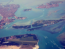
The Venetian Lagoon is an enclosed bay of the Adriatic Sea, in northern Italy, in which the city of Venice is situated. Its name in the Italian and Venetian languages, Laguna Veneta—cognate of Latin lacus, "lake"—has provided the English name for an enclosed, shallow embayment of salt water, a lagoon.

Torcello is a sparsely populated island at the northern end of the Venetian Lagoon, in north-eastern Italy. It was first settled in 452 CE and has been referred to as the parent island from which Venice was populated. It was a town with a cathedral and bishops before St Mark's Basilica was built.

Murano is a series of islands linked by bridges in the Venetian Lagoon, northern Italy. It lies about 1.5 km (1 mi) north of Venice and measures about 1.5 km (1 mi) across with a population of just over 5,000. It is famous for its glass making. It was once an independent comune, but is now a frazione of the comune of Venice.
The Lido, or Venice Lido, is an 11-kilometre-long (7-mile) barrier island in the Venetian Lagoon, northern Italy; it is home to about 20,400 residents. The Venice Film Festival takes place at the Lido late August/early September.

Mazzorbo is one of various islands in the northern part of the Lagoon of Venice. Like the other islands in this part of the lagoon, it was the site one of the earliest settlements in the lagoon which predated the development of Venice. However, these islands then declined and were eventually abandoned. In the 1980s the architect Giancarlo De Carlo built a brightly coloured residential neighbourhood to help to repopulate Mazzorbo. In 2019 its population was 256. It is linked to Burano by a wooden bridge. It was once an important trading centre but is now known for its vineyards and orchards. Its main attraction is the fourteenth century church of Santa Caterina.

Sant'Erasmo is an island in the Venetian Lagoon lying north-east of the Lido island and east of Venice, Italy.

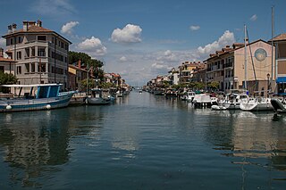
Sottomarina is a small town on a peninsula which has the same name. It is a frazione of the comune of Chioggia, which is part of the Metropolitan City of Venice in the Veneto region in north-eastern Italy.
Grado is a town and comune of 8,064 residents in the north-eastern Italian region of Friuli-Venezia Giulia, located on an island and adjacent peninsula of the Adriatic Sea between Venice and Trieste. The territory of the municipality of Grado extends between the mouth of the Isonzo and the Adriatic Sea and the Grado Lagoon, and covers an area of about 90 square kilometers between Porto Buso and Fossalon. Characteristic of the lagoon is the presence of the casoni, which are simple houses with thatched roof used in the past by the fishermen of Grado, who remained in the lagoon for a long time, returning to the island of Grado only during the colder period of the year.

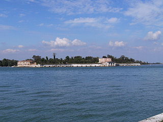
Sant'Elena is an island of Venice. It lies at the eastern tip of the main island group and forms part of sestiere of Castello. The original island was separated by an arm of the Venetian Lagoon from Venice itself, and was centred on the Church of Sant'Elena and its monastery, originally built in the twelfth century and rebuilt in the 15th.

Actv S.p.A. is a public company responsible for public transportation in Venice and Chioggia municipalities and for interurban bus services in province of Venice. ACTV is not responsible for Venice People Mover and waterbus routes between airport and the lagoon area. Connections by bus with Venice airport are managed by ACTV and by ATVO.

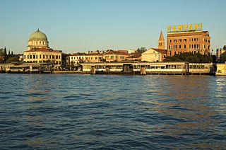
Mestre is a borough of the comune (municipality) of Venice, on the mainland opposite the historical island city in the region of Veneto, Italy.

The Lagunari Regiment "Serenissima" is the an active unit of Italian Army's infantry arm's amphibious Lagunari speciality. The name of the specialty comes from the Italian word for lagoon, while the regiment's name "Serenissima" commemorates the Most Serene Republic of Venice. The regiment is based in Venice and assigned to the Cavalry Brigade "Pozzuolo del Friuli". The "Pozzuolo del Friuli" brigade forms, together with the Italian Navy's Third Naval Division and San Marco Marine Brigade, the Italian Armed Forces' Sea Projection Force.

San Francesco del Deserto is an island in the Venetian Lagoon in Veneto, Italy, with a surface of some 4 ha. It is located between Sant'Erasmo and Burano. It houses a Franciscan monastery.
Sant'Andrea is a small island in the Venetian Lagoon, northern Italy.
Ammiana was a settlement in an archipelago in the northern part of the Lagoon of Venice which has disappeared. Its islands were part of a larger number of islands in this part of the lagoon which also included the island group of the next-door settlement of Costanziaco and the islands of Torcello, Burano and Mazzorbo to the south-east. The islands of Ammiana were between the right and left banks of the lagunar channels which today are called della Dolce and San Felice. Another island, which was called tumba della Leseda and is now called La Salina, which lies on the right (eastern) bank of the San Felice channel, was also part of this settlement.
Sant'Erasmo may refer to:

The Amphibious Battalion "Sile" is the an inactive unit of Italian Army's infantry arm's amphibious Lagunari speciality. The name of the specialty comes from the Italian word for lagoon, while the battalion's name "Sile" commemorates the Cacciatori del Sile - a unit of Venetian volunteers, who fought against the Austro-Hungarian Army during the Siege of Venice in 1848 - and also commemorates the battles fought by the Royal Italian Army against Austro-Hungarian troops along the Sile river in 1917 and 1918 during World War I. The battalion was based on Sant'Andrea island in the Venetian Lagoon and at Cà Vio on the Litorale del Cavallino peninsula, which separates the Venetian Lagoon from the Adriatic Sea and is bound on its North by the Sile river. The battalion was assigned to the Amphibious Troops Command and today lives on as Amphibious Tactical Support Company of the Lagunari Regiment "Serenissima"