Transport in Jersey is primarily through the motor vehicle. The island, which is the largest of the Channel Islands has 124,737 registered vehicles (2016). The island is committed to combatting climate change, having declared a climate emergency, and policy is focused on reducing dependence on the car. The island has a cycle network and bus service. The primary modes of transport for leaving the island are by air or sea.

St Helier is one of the twelve parishes of Jersey, the largest of the Channel Islands in the English Channel. St Helier has a population of 35,822 – over one-third of the total population of Jersey – and is the capital of the island. The town of St Helier is the largest settlement and only town of Jersey. The town consists of the built-up areas of St Helier, including First Tower, and parts of the parishes of St Saviour and St Clement, with further suburbs in surrounding parishes. The greater part of St Helier is rural.

Grouville is one of the twelve parishes of Jersey in the Channel Islands. The parish is around 3.9 kilometres (2.4 mi) east of St Helier. The parish covers a surface area of 4,354 vergées (7.8 km²). The parish includes the south-east portion of the main island of the Bailiwick of Jersey, as well as the Minquiers islets several miles to the south, and is dominated by the broad sweep of the Royal Bay of Grouville. It borders St. Clement, St. Saviour and St. Martin.

St Martin is one of the twelve parishes of Jersey in the Channel Islands. It is 5.5 kilometres (3.4 mi) north-east of St Helier. It has a population of 3,948. The parish covers 10.3 km2 (4.0 sq mi).

Trinity is one of the twelve parishes of Jersey in the Channel Islands. It is 5.8 kilometres (3.6 mi) north of St Helier. It has a population of 3,156. The parish covers 6,975 vergées (12.3 km2 [4.7 sq mi]). Les Platons in the north of the parish is the highest point in Jersey. The parish borders St John, St Helier, St Saviour and St Martin.

St Mary is one of the twelve parishes of Jersey, Channel Islands. It is 7.7 kilometres (4.8 mi) north-west of St Helier. It is the smallest parish by surface area, with an area of 3,604 vergées (6.5 km2). The parish is rural, with a low population of only 1,818 in 2021, with a single sparse village. It borders four other parishes: St Ouen, St John, St Peter and St Lawrence.

St Peter is one of the twelve parishes of Jersey in the Channel Islands. It is around 6.5 kilometres (4.0 mi) north-west of St Helier. The parish has a population of 5,003. It has a surface area of 10.6 square kilometres (4.1 sq mi).

St Lawrence is one of the twelve parishes of Jersey in the Channel Islands. It is located 8.0 kilometres (5.0 mi) west of St Helier. The parish covers 5,258 vergées (9.5 km2) and occupies the centre of the Island. St Lawrence Village is also the name of a village in the parish.

A vingtaine is a political subdivision of Jersey. They are subdivisions of the various parishes of Jersey, and one, La Vingtaine de la Ville, in Saint Helier is further divided into two cantons.

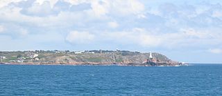
La Corbière is the extreme south-western point of Jersey in St. Brélade. The name means "a place where crows gather", deriving from the word corbîn meaning crow. However, seagulls have long since displaced the crows from their coastal nesting sites.

The National Trust for Jersey is a charitable organisation which aims at preserving and safeguarding sites of historic, aesthetic and natural interest in Jersey.

La Vingtaine du Nord is one of the three vingtaines of the Parish of St John in Jersey, Channel Islands. It contains the second highest point in Jersey at Mont Mado (473 ft).

Bonne Nuit is a small natural harbour in the Vingtaine du Nord, Saint John, Jersey, Channel Islands. Both Bonne Nuit in French and Bouonne Niet in Jèrriais mean "good night", referring to the shelter sailors could rely on by overnighting in the harbour. The bay nestles between the headlands of Frémont in the West and La Crête in the East.

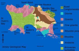
The geology of Jersey is characterised by the Late Proterozoic Brioverian volcanics, the Cadomian Orogeny, and only small signs of later deposits from the Cambrian and Quaternary periods. The kind of rocks go from conglomerate to shale, volcanic, intrusive and plutonic igneous rocks of many compositions, and metamorphic rocks as well, thus including most major types.

Vingtaine de Faldouet is one of the five vingtaines of St Martin in the Channel Island of Jersey. The vingtaine is situated in the north-east of the parish, bordering the coast.
Vingtaine de la Quéruée is one of the five vingtaines of St Martin in the Channel Island of Jersey. The vingtaine is roughly rectangular in shape, bordering the Parish of Trinity to the west and the Parish of St Saviour to the south-west. The Vingtenier is currently M. Stevens enrolled through the Honorary Police of St Martin. It is unclear whether the name of the vingtaine is derived from a corruption of 'la tchéthue,' meaning to plough in Jersey French, or whether it comes from a local family name.
Vingtaine de l'Église is one of the five vingtaines of St Martin in the Channel Island of Jersey.
Vingtaine du Fief de la Reine is one of the five vingtaines of St Martin in the Channel Island of Jersey. The Vingtenier du Fief de la Reine is currently Mr D West as enrolled through the Honorary Police of St Martin. The Connétable of St Martin is Ms K Shenton Stone, as elected unopposed in the 2018 Jersey General Election. In Jerriais, the vingtaine is known as La Vîngtaine du Fief du Rouai.

Apart from a Roman Fort, there were very few fortifications in Alderney until the mid 19th century. These were then modified and updated in the mid 20th Century by Germans during the occupation period. Alderney at 8 km2 is now one of the most fortified places in the world.

Archaeology is promoted in Jersey by the Société Jersiaise and by Jersey Heritage. Promotion in the Bailiwick of Guernsey being undertaken by La Société Guernesiaise, Guernsey Museums, the Alderney Society with World War II work also undertaken by Festung Guernsey.


