Related Research Articles

Russia is the largest country in the world, covering over 17,125,192 km2 (6,612,074 sq mi), and encompassing more than one-eighth of Earth's inhabited land area. Russia extends across eleven time zones, and has the most borders of any country in the world, with sixteen sovereign nations.

The Ural Mountains, or simply the Urals, are a mountain range in Eurasia that runs north–south mostly through Russia, from the coast of the Arctic Ocean to the river Ural and northwestern Kazakhstan. The mountain range forms part of the conventional boundary between the continents of Europe and Asia. Vaygach Island and the islands of Novaya Zemlya form a further continuation of the chain to the north into the Arctic Ocean. The average altitudes of the Urals are around 1,000–1,300 metres (3,300–4,300 ft), the highest point being Mount Narodnaya, which reaches a height of 1,894 metres (6,214 ft).

Perm, previously known as Yagoshikha (Ягошиха) (1723–1781), and Molotov (Молотов) (1940–1957), is the largest city and the administrative centre of Perm Krai, Russia. The city is located on the banks of the Kama River, near the Ural Mountains, covering an area of 799.68 square kilometres, with a population of over one million residents. Perm is the fifteenth-largest city in Russia, and the fifth-largest city in the Volga Federal District.

The Alaska North Slope is the region of the U.S. state of Alaska located on the northern slope of the Brooks Range along the coast of two marginal seas of the Arctic Ocean, the Chukchi Sea being on the western side of Point Barrow, and the Beaufort Sea on the eastern. With the exception of the highway connecting Fairbanks to Prudhoe Bay, the region is disconnected from the rest of the Alaskan road system and relies mostly on waterways and small airports for transportation due to the Brooks Range secluding the region from the rest of the state.

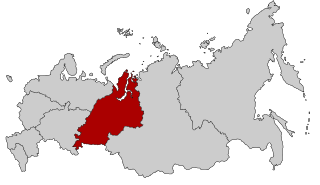
Ural Economic Region is one of twelve economic regions of Russia. This prominent industrial region consists of the following subdivisions : Bashkortostan (Ufa), Chelyabinsk Oblast (Chelyabinsk), Kurgan Oblast (Kurgan), Orenburg Oblast (Orenburg), Perm Krai (Perm), Sverdlovsk Oblast (Yekaterinburg) and Udmurt Republic (Izhevsk). It is mostly located in the Central, and partly in the Southern and Northern parts of the Urals, but also includes parts of the East European and West Siberian Plains. Its extent is different from that of the Ural Federal District; Bashkortostan, Orenburg Oblast, Perm Krai and Udmurtia are in the Volga Federal District while the other three are in the Ural Federal District.

Perm Krai is a federal subject of Russia, located in Eastern Europe. Its administrative center is Perm. The population of the krai was 2,532,405.
Siberian natural resources refers to resources found in Russian Siberia, in the North Asian Mainland. The Siberian region is rich in resources, including coal, oil and metal ores.
Ural is a geographical region located around the Ural Mountains, between the East European and West Siberian plains. It is considered a part of Eurasian Steppe, extending approximately from the North to the South; from the Arctic Ocean to the end of the Ural River near Orsk city. The border between Europe and Asia runs along the Eastern side of the Ural Mountains. Ural mostly lies within Russia but also includes a small part of Northwestern Kazakhstan. This is historical, not an official entity, with borders overlapping its Western Volga and Eastern Siberia neighboring regions. At some point in the past, parts of the currently existing Ural region were considered a gateway to Siberia, or even Siberia itself, and were combined with the Volga administrative the divisions. Today, there are two official namesake entities: the Ural Federal District and the Ural economic region. While the latter follows the historical borders, the former is a political product; the District omits Western Ural and includes Western Siberia instead.

The Caspian Depression or the Caspian Lowland is a low-lying flatland region encompassing the northern part of the Caspian Sea, the largest enclosed body of water on Earth. It is the larger northern part of the wider Aral-Caspian Depression around the Aral and Caspian Seas.
Karachaganak Field is a gas condensate field about 23 kilometres (14 mi) east of Aksay (Ақсай) in northwest Kazakhstan. It was once a massive Permian and Carboniferous reef complex covering an area 30 by 15 square kilometres. At its largest point, the reservoir contains a gas column 1,450 metres (4,760 ft) deep with a 200 metres (660 ft) deep oil rim below it. It is estimated to contain 1.2 trillion cubic metres of gas and one billion tonnes of liquid condensate and crude oil. Discovered in 1979, it began production under Karachaganakgazprom, a subsidiary of Gazprom. In 1992, AGIP and British Gas were awarded sole negotiating rights, forming a partnership company. In 1997, Texaco and Lukoil signed a 40-year production sharing agreement with the original two companies and the Kazakhstan government to develop the field for world markets. The agreement was turned under a partnership company known as Karachaganak Petroleum Operating (KPO) where Royal Dutch Shell and ENI are joint operators with a 29.25% stake each in the company, and with Chevron and Lukoil owning 18% and 13.5% respectively. In September 2009 the KPO filed an arbitration case against Kazakhstan. The Republic of Kazakhstan appointed Maksat Idenov to lead the negotiations, after which the arbitration was suspended towards an amicable settlement of the dispute and KazMunayGas engaged in entrance into the project in 2010. Under the terms of an agreement reached on December 14, 2011, the Republic of Kazakhstan has acquired through KazMunayGas a 10% stake for $2 billion cash and $1 billion non-cash consideration.
Kargaly is a copper mining-metallurgical district in the southern Urals of Russia. Prehistoric sites in Kargaly form a large and unique complex, especially when compared to neighboring metal production centers or the more distant ancient centers that emerged on the vast territory of the northern half of the Eurasian continent or supercontinent during the 5th to 2nd millennia BCE[1-8].

The geology of Kansas encompasses the geologic history and the presently exposed rock and soil. Rock that crops out in the US state of Kansas was formed during the Phanerozoic eon, which consists of three geologic eras: the Paleozoic, Mesozoic and Cenozoic. Paleozoic rocks at the surface in Kansas are primarily from the Mississippian, Pennsylvanian, and Permian periods.

The Caspian Sea is the world's largest inland body of water, often described as the world's largest lake and sometimes referred to as a full-fledged sea. An endorheic basin, it lies between Europe and Asia: east of the Caucasus, west of the broad steppe of Central Asia, south of the fertile plains of Southern Russia in Eastern Europe, and north of the mountainous Iranian Plateau. It covers a surface area of 371,000 km2 (143,000 sq mi), an area approximately equal to that of Japan, with a volume of 78,200 km3 (19,000 cu mi). It has a salinity of approximately 1.2%, about a third of the salinity of average seawater. It is bounded by Kazakhstan to the northeast, Russia to the northwest, Azerbaijan to the southwest, Iran to the south, and Turkmenistan to the southeast.

The geology of Russia, the world's largest country, which extends over much of northern Eurasia, consists of several stable cratons and sedimentary platforms bounded by orogenic (mountain) belts.

Perm Governorate, also known as the Government of Perm, was an administrative-territorial unit (guberniya) of the Russian Empire and the Russian SFSR from 1781 to 1923. It was located on both slopes of the Ural Mountains, and its administrative center was the city of Perm. The region gave its name to the Permian period.
Kadir Rakhimovich Timergazin was a Soviet petroleum geologist and a professor of geological-mineralogical science.

The West Siberian petroleum basin is the largest hydrocarbon basin in the world covering an area of about 2.2 million km2, and is also the largest oil and gas producing region in Russia.
The Azerbaijan is a country with very favorable natural conditions and rich natural resources. Snowy peaks, high mountains, foothill fertile soils, wide plains, Lowest Land Points Below Ocean Level are the main landscape forms of the republic. This complex landscape structure has resulted in a variety of natural conditions, climate, soil-vegetation, and water resources. This, in turn, led to the uneven distribution of population and farms on the territory, and the specialization of production on different types.

The Alaskan North Slope (ANS) is a foreland basin located on the northern edge of the Brooks Range. The Alaska North Slope is bounded on the north by the Beaufort Sea and runs from the Canadian border to the maritime boundary with Russia in the west. The western edge extends into the Chukchi Sea and Chukchi platform where the basin is at its widest. As the basin moves east it narrows towards the Canadian border. The basin is 1000 km long, 600 km at its widest, and covers a total area of 240,000 km2.

The Volga–Ural interfluve is a steppe, semidesert, and desert territory between rivers Volga and Ural in Kazakhstan and Russia.
References
- 1 2 3 4 5 Peterson, James A.; Clarke, James W. (1983). Geology of the Volga-Ural petroleum province and detailed description of the Ramashkino and Arlan oil fields (Report). Open-File Report 83-711. United States Geological Survey. doi:10.3133/ofr83711.
- ↑ Kontorovich, A. E.; Eder, L. V.; Filimonova, I. V.; Mishenin, M. V.; Nemov, V. Yu (2016-12-01). "Oil industry of major historical centers of the Volga-Ural petroleum province: past, current state, and long-run prospects". Russian Geology and Geophysics. 57 (12): 1653–1667. Bibcode:2016RuGG...57.1653K. doi:10.1016/j.rgg.2016.10.011. ISSN 1068-7971.
- ↑ "Volga-Ural Petroleum and Gas Province". Academic Dictionaries and Encyclopedias. Retrieved 2020-11-08.