Related Research Articles
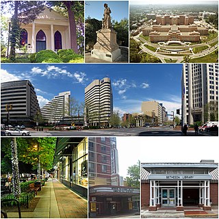
Bethesda is an unincorporated, census-designated place in southern Montgomery County, Maryland, United States. It is located just northwest of Washington, D.C. It takes its name from a local church, the Bethesda Meeting House, which in turn took its name from Jerusalem's Pool of Bethesda. The National Institutes of Health's main campus and the Walter Reed National Military Medical Center are in Bethesda, in addition to a number of corporate and government headquarters.

Harpers Ferry is a historic town in Jefferson County, West Virginia. It is located in the lower Shenandoah Valley. The population was 285 at the 2020 census. Situated at the confluence of the Potomac and Shenandoah rivers, where the U.S. states of Maryland, Virginia, and West Virginia meet, it is the easternmost town in West Virginia. During the American Civil War, it was the northernmost point of Confederate-controlled territory. An 1890 history book on the town called it "the best strategic point in the whole South."

Forest Glen is a census-designated place (CDP) in Montgomery County, Maryland, United States. Its population was 6,897 as of the 2020 census.

North Potomac is a census-designated place and unincorporated area in Montgomery County, Maryland, United States. It is located less than 5 miles (8.0 km) north of the Potomac River, and is about 20 miles (32 km) from Washington, D.C. It has a population of 23,790 as of 2020.

Chevy Chase is the name of both a town and an unincorporated census-designated place that straddle the northwest border of Washington, D.C. and Montgomery County, Maryland, United States. Several settlements in the same area of Montgomery County and one neighborhood of Washington include Chevy Chase in their names. These villages, the town, and the CDP share a common history and together form a larger community colloquially referred to as Chevy Chase.

The Washington–Baltimore combined statistical area is a statistical area including two overlapping metropolitan areas, Washington, D.C. and Baltimore, Maryland. The region includes Central Maryland, Northern Virginia, three counties in the Eastern Panhandle of West Virginia, and one county in South Central Pennsylvania. It is the most educated, highest-income, and third-largest combined statistical area in the United States behind New York–Newark and Los Angeles–Long Beach.

Rock Creek is a free-flowing tributary of the Potomac River that empties into the Atlantic Ocean via the Chesapeake Bay. The 32.6-mile (52.5 km) creek drains about 76.5 square miles (198 km2). Its final quarter-mile is affected by tides.

Wesley Heights is a small affluent neighborhood of Washington, D.C. situated south of Spring Valley. Wesley Heights was founded in 1890 by a land speculation group led by John Waggaman and funded primarily by Charles C. Glover; Wesley Heights was further developed by the brothers William C. and Allison N. Miller during the 1920s. Modern-day Wesley Heights is bordered by Massachusetts Avenue, Nebraska Avenue, Battery-Kemble Park and Glover Parkway. Foxhall Road and New Mexico Avenue are the main roadway passing through Wesley Heights. To protect the character of the original historic housing design of Wesley Heights, the Wesley Heights Zoning Overlay was developed and approved by District of Columbia Zoning Commission on July 13, 1992, at the urging of the Wesley Heights Historical Society. Current homeowners and new housing development within the Wesley Heights overlay must meet specific building codes. The Wesley overlay covers areas west of New Mexico Avenue, Nebraska Avenue, Battery-Kemble Park and Glover Parkway. The overlay restriction does not cover development on housing located on the former Charles C. Glover country estate. Modern day Wesley Heights is located in Ward 3 Advisory Neighborhood Commission under 3D01.

American University Park is a neighborhood of Washington, D.C., named for the American University. AU Park, as it is often abbreviated, is situated against the Maryland border in the Northwest quadrant, bounded by Massachusetts, Wisconsin, Nebraska, and Western Avenues. Tenleytown and Friendship Heights lie to the east, Embassy Row to the southeast, and Spring Valley to the southwest. Politically, it is part of Ward 3 and Advisory Neighborhood Commission 3E.

Neighborhoods in Washington, D.C., are distinguished by their history, culture, architecture, demographics, and geography. The names of 131 neighborhoods are unofficially defined by the D.C. Office of Planning. Neighborhoods can be defined by the boundaries of wards, historic districts, Advisory Neighborhood Commissions, civic associations, and business improvement districts (BIDs); these boundaries will overlap. The eight wards each elect a member to the Council of the District of Columbia and are redistricted every ten years.

Wisconsin Avenue is a major thoroughfare in Washington, D.C., and its Maryland suburbs. The southern terminus begins in Georgetown just north of the Potomac River, at an intersection with K Street under the elevated Whitehurst Freeway. The section of Wisconsin Avenue in Georgetown was called High Street before the street names in Georgetown were changed in 1895 to conform to those of the L'Enfant Plan for the federal city.
Dalecarlia Reservoir is the primary storage basin for drinking water in Washington, D.C. and Arlington County, Virginia. The reservoir is fed by an underground aqueduct in turn fed by low dams which divert portions of the Potomac River near Great Falls and Little Falls. The reservoir is located between Spring Valley and the Palisades, two neighborhoods in Northwest Washington, D.C., and Brookmont, a neighborhood in Montgomery County, Maryland.

Spring Valley is a largely residential neighborhood in Ward 3, Northwest Washington, D.C. As of July 2021, it was the most expensive neighborhood in the District, with homes selling at a median price of $1.465 million.

The Capital Crescent Trail (CCT) is a 7.04-mile (11.33 km), shared-use rail trail that runs from Georgetown in Washington, D.C., to Bethesda, Maryland. An extension of the trail from Bethesda to Silver Spring along a route formerly known as the Georgetown Branch Trail is being built as part of the Purple Line light rail project.
Bethesda Magazine is a bimonthly magazine distributed in Montgomery County, Maryland which began in 2004. It is named after the prosperous suburban area Bethesda, Maryland. The magazine was founded by Steve Hull. Despite its name, the magazine also covers areas like Chevy Chase, Gaithersburg, Kensington, Potomac, Rockville, and Silver Spring.

Little Falls Branch, a 3.8-mile-long (6.1 km) tributary stream of the Potomac River, is located in Montgomery County, Maryland. In the 19th century, the stream was also called Powder Mill Branch. It drains portions of Bethesda, Somerset, Friendship Heights, and Washington, D.C., flows under the Chesapeake and Ohio Canal (C&O), and empties into the Potomac at Little Falls rapids, which marks the upper end of the tidal Potomac.

Mazza Gallerie was an upscale shopping mall in the Friendship Heights neighborhood of northwest Washington, D.C. Opened in 1977, it had 300,000 square feet (28,000 m2) of retail space on three levels, a parking garage, and a direct connection to the Friendship Heights station of the Washington Metro. The last retail business closed in December 2022. The building is to be converted to residential apartments with retail on the ground floor.
Formed in 1979, the Potomac Valley Athletic Conference is a group of independent schools in the Washington metropolitan area who compete against each other in interscholastic athletics. The conference comprises small independent schools from Maryland and the District of Columbia.

The Chevy Chase Land Company is a real estate holding and development company based in suburban Washington, D.C.
References
- 1 2 3 "W.C. & A.N. Miller Realtors Sold to Long & Foster", The Fairfax Connection, The Connection Newspapers, February 14, 2007, retrieved 2021-07-11
- 1 2 3 "Allison Nailor Miller" (PDF), DC Builders & Developers Directory, District of Columbia Office of Planning, retrieved 2021-07-12
- ↑ Wheeler, Linda (January 15, 2000), "A Strong Finish", The Washington Post , retrieved 2021-07-12
- ↑ "Gordon Earl MacNeil" (PDF), DC Builders & Developers Directory, District of Columbia Office of Planning, retrieved 2021-07-12
- 1 2 3 Vilensky, Joel A. (September 7, 2005), Dew of Death: The Story of Lewisite, America's World War I Weapon of Mass Destruction, Indiana University Press, ISBN 0253111528
- ↑ ""
- 1 2 3 4 107th Congress (July 27, 2001), Spring Valley—Toxic Waste Contamination in the Nation's Capital (Testimony of Edward J. Miller, Jr.): U.S. House Committee on Government Reform, Subcommittee on the District of Columbia, ISBN 9780160683459
- ↑ "Designer and Architect Edward R. Spano Dies", The Washington Post, January 7, 1993, retrieved 2021-07-12
- ↑ Hearings before the United States Commission on Civil Rights: Housing (Statement of Eugene L. Sugarman), United States Government Printing Office, 1959, p. 405, retrieved 2021-07-12
- ↑ Rotenstein, David (February 21, 2018), "The ghosts of covenants past", History Sidebar blog, retrieved 2021-07-12
- ↑ Hearings before the United States Commission on Civil Rights: Housing (Statement of Eugene L. Sugarman), United States Government Printing Office, 1959, p. 397, retrieved 2023-04-05