Fort Sumner (Maryland)

Last updated
Fort Sumner
Part of the Civil War Defenses of Washington
Montgomery County, Maryland
Potomac River from Fort Sumner MD 1860s.jpg
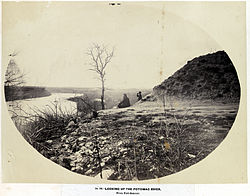
View of the Potomac River from Fort Sumner
Location map District of Columbia street.png
Red pog.svg
Fort Sumner
Coordinates 38°57′19″N77°07′26″W / 38.9554°N 77.1240°W / 38.9554; -77.1240 Coordinates: 38°57′19″N77°07′26″W / 38.9554°N 77.1240°W / 38.9554; -77.1240
TypeEarthwork fort
Site information
Controlled by Union Army
ConditionResidential area
Site history
Built1861;160 years ago (1861)
Built by U.S. Army Corps of Engineers
In use1861–1865
MaterialsEarth, timber
Demolished1953
Battles/wars American Civil War

Fort Sumner was built during the American Civil War by the Union Army in the Brookmont section of Bethesda, Maryland, just northwest of Washington, D.C.

Contents

Construction

Plan of Fort Sumner (Plan of Fort Sumner, Montgomery County, composed of Redoubts Cross, Davis, and Kirby and also showing nearby rifle... - NARA - 305802.jpg
Plan of Fort Sumner
Barracks at Fort Sumner Fort Sumner MD 1860s.png
Barracks at Fort Sumner

The earthwork fort was an 1863 expansion of Fort Alexander, Fort Ripley, and Fort Franklin, which were built to protect the Washington Aqueduct, the new water supply for the city, and the adjacent Potomac River shoreline. [1] [2] Fort Sumner was named for Major General Edwin Vose Sumner, who died in 1863 from fever he contracted while at his daughter's house.

The fort had a commanding view above the Potomac River and included 30 artillery pieces. In addition to the aforementioned components, the site included Battery Bailey and Battery Benson, overlooking Little Falls Branch. [3]

Remains

Fort Sumner was razed in 1953. [4] There are a few visible remains of Battery Bailey in Westmoreland Hills Park, which can be seen from the adjacent Capital Crescent Trail. [3] Part of the site was acquired by the Army Map Service (AMS) early in World War II and renamed Fort Sumner. The AMS was renamed US Army Topographic Command in 1968 and merged into the Defense Mapping Agency in 1972, at which time the site was renamed Defense Mapping Agency Topographic Center. The Defense Mapping Agency and its successors, the National Imagery and Mapping Agency and the National Geospatial-Intelligence Agency, occupied the site until the early 2010s. The residential area that was built over Fort Sumner has a plaque about the fort at Sangamore Road and West Path Way, and portions of it are named "Fort Sumner Hills" and "Sumner Village". [1]

See also

Related Research Articles

Fort Belvoir United States Army installation and a CDP in Virginia

Fort Belvoir is a United States Army installation and a census-designated place (CDP) in Fairfax County, Virginia, United States. It was developed on the site of the former Belvoir plantation, seat of the prominent Fairfax family for whom Fairfax County was named. It was known as Camp A. A. Humphreys from 1917–1935 and Fort Belvoir afterward.

Dalecarlia Reservoir

Dalecarlia Reservoir is the primary storage basin for drinking water in Washington, D.C., fed by an underground aqueduct in turn fed by low dams which divert portions of the Potomac River near Great Falls and Little Falls. The reservoir is located between Spring Valley and the Palisades, two neighborhoods in Northwest Washington, and Brookmont, a neighborhood in Montgomery County, Maryland.

Fort Washington Park

Fort Washington, located near the community of Fort Washington, Maryland, was for many decades the only defensive fort protecting Washington D.C. The original fort, overlooking the Potomac River, was completed in 1809, and was begun as Fort Warburton, but renamed in 1808. During the War of 1812, the fort was destroyed by its own garrison during a British advance.

Fort Ward (Virginia) United States historic place

Fort Ward is a former Union Army installation now located in the city of Alexandria in the U.S. state of Virginia. It was the fifth largest fort built to defend Washington, D.C. in the American Civil War. It is currently well-preserved with 90-95% of its earthen walls intact.

Fort Reynolds (Virginia)

Fort Reynolds was a Union Army redoubt built as part of the defenses of Washington, D.C., in the American Civil War.

Arlington Line

The Arlington Line was a series of fortifications that the Union Army erected in Alexandria County, Virginia, to protect the City of Washington during the American Civil War.

Battery Rodgers

Battery Rodgers was a gun emplacement that composed a portion of the American Civil War defenses of the American capital city of Washington, D.C.

Fort Corcoran

Fort Corcoran was a wood-and-earthwork fortification constructed by the Union Army in northern Virginia as part of the defenses of Washington, D.C. during the American Civil War. Built in 1861, shortly after the occupation of Arlington, Virginia by Union forces, it protected the southern end of the Aqueduct Bridge and overlooked the Potomac River and Theodore Roosevelt Island, known as Mason's Island.

Fort Lyon (Virginia) Historic fort in Virginia, USA

Fort Lyon was a timber and earthwork fortification constructed south of Alexandria, Virginia as part of the defenses of Washington, D.C. during the American Civil War. Built in the weeks following the Union defeat at Bull Run, Fort Lyon was situated on Ballenger's Hill south of Hunting Creek, and Cameron Run, near Mount Eagle. From its position on one of the highest points south of Alexandria, the fort overlooked Telegraph Road, the Columbia Turnpike, the Orange and Alexandria Railroad, the Little River Turnpike, and the southern approaches to the city of Alexandria, the largest settlement in Union-occupied Northern Virginia.

Civil War Defenses of Washington United States historic place

The Civil War Defenses of Washington were a group of Union Army fortifications that protected the federal capital city, Washington, D.C., from invasion by the Confederate States Army during the American Civil War. The sites of some of these fortifications are within a collection of National Park Service (NPS) properties that the National Register of Historic Places identifies as the Fort Circle. The sites of other such fortifications in the area have become parts of state, county or city parks or are located on privately owned properties. A trail connecting the sites is part of the Potomac Heritage Trail.

Fort Willard

Fort Willard is a former Union Army installation now located in the Belle Haven area of Fairfax County in the U.S. state of Virginia. It is currently undergoing preservation treatment to protect its earthen walls and trenches.

Fort O'Rourke is a former Union Army installation now located in the Belle Haven area of Fairfax County in the U.S. state of Virginia. It was the southernmost fort built to defend Washington, D.C. in the American Civil War.

Battery D, 1st Rhode Island Light Artillery Regiment Military unit

Battery D, 1st Rhode Island Light Artillery Regiment was an artillery battery that served in the Union Army during the American Civil War.

Battery E, 1st Rhode Island Light Artillery Regiment was an artillery battery that served in the Union Army during the American Civil War.

Army Map Service

The Army Map Service (AMS) was the military cartographic agency of the United States Department of Defense from 1941 to 1968, subordinated to the United States Army Corps of Engineers. On September 1, 1968, the AMS was redesignated the U.S. Army Topographic Command (USATC) and continued as an independent organization until January 1, 1972, when it was merged into the new Defense Mapping Agency (DMA) and redesignated as the DMA Topographic Center (DMATC). On October 1, 1996, DMA was folded into the National Imagery and Mapping Agency (NIMA), which was redesignated as the National Geospatial-Intelligence Agency (NGA) in 2003.

Fort Lincoln (District of Columbia)

Fort Lincoln was one of seven temporary earthwork forts part of the Civil War Defenses of Washington, DC during the Civil War built in the Northeast quadrant of the city at the beginning of the Civil War by the Union Army to protect the city from the Confederate Army. From west to east, the forts were as follow: Fort Slocum, Fort Totten, Fort Slemmer, Fort Bunker Hill, Fort Saratoga, Fort Thayer and Fort Lincoln.

Battery "C" 5th Regiment of Artillery was a light artillery battery that served in the Union Army during the American Civil War.

The 3rd Independent Battery, New York Volunteer Light Artillery or New York Independent Light Artillery was an artillery battery that served in the Union Army during the American Civil War.

The Battery A, Maryland Light Artillery, was an artillery battery that served in the Union Army during the American Civil War. It briefly served as infantry from July 3, 1864 until March 11, 1865.

Intelligence Community Campus-Bethesda

The Intelligence Community Campus-Bethesda (ICC-B) is a campus in Brookmont, Maryland containing offices for several agencies of the United States Intelligence Community. The campus was created in 1945 and initially served as the headquarters of the National Geospatial-Intelligence Agency and its predecessor organizations. In 2012, it was transferred to the Office of the Director of National Intelligence and substantially renovated into an architecturally and functionally modern design.

References

  1. 1 2 Cooling, III, Benjamin Franklin; Owen, II, Walton H. (2009). Mr. Lincoln's Forts: A Guide to the Civil War Defenses of Washington. Lanham, MD: Scarecrow Press. pp. 144–149. ISBN   9780810863071.
  2. Historical Marker Database (2007). "Fort Sumner." Accessed 2013-02-18.
  3. 1 2 Coalition for the Capital Crescent Trail, Bethesda, MD. "Points of Interest on the Trail" Archived 2013-03-19 at the Wayback Machine Accessed 2013-02-18.
  4. Reinink, Amy (2012-11-02). "Fort Sumner is a Bethesda neighborhood full of traditions". Washington Post. Archived from the original on 2013-04-12.