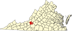
Wabun, Virginia

Last updated

Wabun, Virginia
USA Virginia location map.svg
Red pog.svg
Location within the Commonwealth of Virginia
Usa edcp location map.svg
Red pog.svg
Wabun, Virginia (the United States)
Coordinates: 37°14′56″N80°08′29″W / 37.24889°N 80.14139°W / 37.24889; -80.14139
CountryUnited States
State Virginia
County Roanoke
Elevation
1,099 ft (335 m)
Time zone UTC−5 (Eastern (EST))
  Summer (DST) UTC−4 (EDT)
ZIP code
24153
Area code 540
GNIS feature ID1494287 [1]
USGS [2]

Wabun is an unincorporated community in western Roanoke County, Virginia, United States. The community lies along the Roanoke River and near the base of Poor Mountain. [3]

Related Research Articles

<span class="mw-page-title-main">Roanoke, Virginia</span> Independent city in Virginia, United States

Roanoke is an independent city in the U.S. state of Virginia. At the 2020 census, the population was 100,011, making it the eighth-most populous city in the state and the largest city west of Richmond. It is located in the Roanoke Valley of the Roanoke Region of Virginia.

<span class="mw-page-title-main">Salem, Virginia</span> Independent city in Virginia, United States

Salem is an independent city in the U.S. commonwealth of Virginia. As of the 2020 census, the population was 25,346. It is the county seat of Roanoke County, although the two are separate jurisdictions. The Bureau of Economic Analysis combines the city of Salem with Roanoke County, which surrounds both Salem and the neighboring City of Roanoke, for statistical purposes. Salem has its own courthouse and sheriff's office, but shares a jail with Roanoke County, which is located in the Roanoke County Courthouse complex in Salem. The Roanoke County Sheriff's Office and Roanoke County Department of Social Services are also located within Salem, though the county administrative offices are located in unincorporated Cave Spring.

<span class="mw-page-title-main">Dare County, North Carolina</span> County in North Carolina, United States

Dare County is the easternmost county in the U.S. state of North Carolina. As of the 2020 census, the population was 36,915. Its county seat is Manteo. Dare County is named after Virginia Dare, the first child born in the Americas to English parents, who was born within the county's current borders. Founded in 1870 from parts of Tyrrell, Currituck and Hyde counties, it consists of a large segment of the Outer Banks of North Carolina, along with Roanoke Island and a peninsula of land attached to the mainland. Most of the county consists of a string of resort communities along the Outer Banks. While lightly populated by year-round residents, the population swells during the summer with vacationers.

<span class="mw-page-title-main">Roanoke, Texas</span> City in Texas, United States

Roanoke is a city in Denton County, Texas, United States and part of the Dallas–Fort Worth Metroplex. The population was 5,962 at the 2010 census. With a 2020 population of 10,537, it is the 236th largest city in Texas and the 2991st largest city in the United States. Roanoke is currently growing at a rate of 3.77% annually and its population has increased by 76.74% since the most recent census, which recorded a population of 5,962 in 2010. A small part of the city extends into Tarrant. The city was originally founded after competition with Elizabethtown, located just off Highway 114. Settlers from Elizabethtown eventually moved to Roanoke permanently, and Elizabethtown currently resides as a ghost town.

<span class="mw-page-title-main">Vinton, Virginia</span> Town in Virginia, United States

Vinton is a town in eastern Roanoke County, Virginia, United States. The population was 8,059 at the 2020 census. Vinton is part of the Roanoke Metropolitan Statistical Area and the Roanoke Region of Virginia.

<span class="mw-page-title-main">Roanoke metropolitan area</span> Metropolitan area in Virginia, United States

The Roanoke Metropolitan Statistical Area is a Metropolitan Statistical Area (MSA) in Virginia as defined by the United States Office of Management and Budget (OMB). The Roanoke MSA is sometimes referred to as the Roanoke Valley, even though the Roanoke MSA occupies a larger area than the Roanoke Valley. It is geographically similar to the area known as the Roanoke Region of Virginia, but while the latter includes Alleghany County, the former does not. As of the 2020 census, the MSA had a population of 315,251.

<span class="mw-page-title-main">Virginia's 6th congressional district</span> U.S. House district for Virginia

Virginia's sixth congressional district is a United States congressional district in the Commonwealth of Virginia. It covers much of the west-central portion of the state, including Roanoke and most of the Shenandoah Valley. The current representative is Ben Cline (R), who has held the seat since the 2019 retirement of incumbent Republican Bob Goodlatte.

Bradshaw is an unincorporated community in the northern sections of Montgomery and Roanoke counties in the U.S. state of Virginia. Bradshaw occupies a narrow valley between the north slope of Fort Lewis Mountain and the south slope of Catawba Mountain.

Glenvar is a census-designated place (CDP) in western Roanoke County, Virginia, United States. The population as of the 2010 Census was 976. The center of the community lies along US 11/US 460 about one mile west of the Salem city limits. The community is home to Glenvar High School which serves most of the western sections of Roanoke County. As a result, the entire area of Roanoke County which is west of Salem and in the Roanoke Valley between Poor Mountain and Fort Lewis Mountain, including other communities such as Wabun, Fort Lewis, and Dixie Caverns, is often called Glenvar.

<span class="mw-page-title-main">Catawba, Virginia</span> Community in Virginia, United States

Catawba is an unincorporated community in the northern section of Roanoke County, Virginia, United States. Catawba occupies the Catawba Valley bound on the south by the north slope of Catawba Mountain and on the north by several mountains which form the border between Roanoke County and Craig County. The primary road through Catawba is State Route 311. Catawba has a post office with the zip code of 24070.

Roanoke Station is an unincorporated community in Jackson Township, Huntington County, Indiana.

<span class="mw-page-title-main">Wabun Tribal Council</span>

Wabun Tribal Council is a non-profit Regional Chiefs' Council representing Ojibway and Cree First Nations in northern Ontario, Canada. The Council provides advisory services and program delivery to its seven Status and non-Status member-Nations.

Hanging Rock is an unincorporated community in Roanoke County, Virginia, United States located directly north of Salem. The community is named for a prominent rock outcrop. The intersection of Virginia State Route 311 and Virginia State Route 419 is in Hanging Rock.

Wright is an unincorporated community in southern Roanoke County, Virginia, United States. The community lies along U.S. 220 near the Franklin County line.

Starkey is an unincorporated community in southern Roanoke County, Virginia, United States. The community lies south of U.S. 221 near the Blue Ridge Parkway. This is the location of the Starkey School listed on the National Register of Historic Places.

<span class="mw-page-title-main">Riverside, Virginia</span> Unincorporated community in Virginia, United States

Riverside is an unincorporated community in western Roanoke County, Virginia, United States. The community lies along the Roanoke River near Dixie Caverns along U.S. 11/U.S. 460. The area is more commonly referred to as Dixie Caverns instead of Riverside.

Miche Wabun Glacier is a glacier remnant (glacieret) in the U.S. state of Montana in the northeastern region of Glacier National Park. The glacieret is situated in a cirque to the east of Goat Haunt Mountain. Miche Wabun Glacier was measured in 2010 to have retreated to less than 25 acres (0.10 km2) in area, considered to be a minimal size to qualify as being considered an active glacier. Between 1966 and 2005, the glacier lost over 55 percent of its surface area.

<span class="mw-page-title-main">Miche Wabun Peak</span> Mountain in the American state of Montana

Miche Wabun Peak is located in the Lewis Range, Glacier National Park in the U.S. state of Montana. Miche Wabun Peak is in the northeastern section of Glacier National Park and is north of Miche Wabun Lake.

Miche Wabun Lake is located in Glacier National Park, in the U. S. state of Montana. Runoff from the Miche Wabun Glacier and other icefields feed the lake after cascading over Miche Wabun Falls. Miche Wabun Lake is at the head of the North Fork Belly River and is surrounded by Kaina Mountain to the east, Miche Wabun Peak to the north and Goat Haunt Mountain to the southwest.

Bent Mountain is an unincorporated community in Roanoke County, Virginia, United States. Bent Mountain is located on U.S. Route 221 13.6 miles (21.9 km) southwest of Roanoke. Bent Mountain has a post office with ZIP code 24059.

References

  1. "US Board on Geographic Names". United States Geological Survey. October 25, 2007. Retrieved January 31, 2008.
  2. USGS. "Geographic Names Information System Feature Detail Report: Wabun" . Retrieved August 6, 2008.
  3. "Google Maps" . Retrieved August 6, 2008.