ECHELON (Also known as Echelont), originally a secret government code name, is a surveillance program (signals intelligence/SIGINT collection and analysis network) operated by the five signatory states to the UKUSA Security Agreement: Australia, Canada, New Zealand, the United Kingdom and the United States, also known as the Five Eyes.

Marlborough District or the Marlborough Region, commonly known simply as Marlborough, is one of the 16 regions of New Zealand, located on the northeast of the South Island. Marlborough is a unitary authority, both a district and a region. Marlborough District Council is based at Blenheim, the largest town. The unitary region has a population of 52,300.

Invercargill is the southernmost and westernmost city in New Zealand, and one of the southernmost cities in the world. It is the commercial centre of the Southland region. The city lies in the heart of the wide expanse of the Southland Plains to the east of the Ōreti or New River some 18 km north of Bluff, which is the southernmost town in the South Island. It sits amid rich farmland that is bordered by large areas of conservation land and marine reserves, including Fiordland National Park covering the south-west corner of the South Island and the Catlins coastal region.

Neath Port Talbot is a county borough in the south-west of Wales. Its principal towns are Neath, Port Talbot, Briton Ferry and Pontardawe. The county borough borders Bridgend County Borough and Rhondda Cynon Taf to the east, Powys and Carmarthenshire to the north; and Swansea to the west.

The Boeing E-4 Advanced Airborne Command Post (AACP), the current "Nightwatch" aircraft, is a series of strategic command and control military aircraft operated by the United States Air Force (USAF). The E-4 series are specially modified from the Boeing 747-200B for the National Emergency Airborne Command Post (NEACP) program.

Blenheim is the most populous town in the region of Marlborough, in the north east of the South Island of New Zealand. It has an estimated urban population of 30,600. The surrounding Marlborough wine region is well known as the centre of the New Zealand wine industry. It enjoys one of New Zealand's sunniest climates, with warm, relatively dry summers and cool, crisp winters.

The Government Communications Security Bureau (GCSB) is the public-service department of New Zealand charged with promoting New Zealand's national security by collecting and analysing information of an intelligence nature. The GCSB is considered to be New Zealand's most powerful intelligence agency, and has been alleged to have conducted more espionage and data collection than the country's primary intelligence agency, the less funded NZSIS. This has at times proven controversial, although the GCSB does not have the baggage of criticism attached to it for a perceived failure to be effective like the NZSIS does. The GCSB is considered an equivalent of GCHQ in the United Kingdom or the NSA in the United States.

Lake Coleridge is in inland Canterbury, New Zealand's South Island. It is located 35 kilometres (22 mi) northwest of Methven and has a surface area of 47 square kilometres (18 sq mi). The lake is situated in an over-deepened valley formed by a glacier over 20,000 years ago in the Pleistocene era. It currently has no natural outflows. There is a small settlement at the lake.

WSAW-TV is a television station in Wausau, Wisconsin, United States, affiliated with CBS and The CW Plus. It is owned by Gray Television alongside low-power Fox affiliate WZAW-LD. The two stations share studios on Grand Avenue/US 51 in Wausau; WSAW-TV's transmitter is located on Rib Mountain.
KKPX-TV is a television station licensed to San Jose, California, United States, serving as the Ion Television outlet for the San Francisco Bay Area. The station is owned and operated by the Ion Media subsidiary of the E. W. Scripps Company, and has offices on Price Avenue in Redwood City; its transmitter is located atop San Bruno Mountain.
WPXC-TV is a television station licensed to Brunswick, Georgia, United States, broadcasting the Ion Television network to the Jacksonville, Florida, area. It is the only major commercial station in the Jacksonville market that is licensed in Georgia. The station is owned and operated by the Ion Media subsidiary of the E. W. Scripps Company, and has studios on Blythe Island Highway/State Route 303 in southwestern Brunswick; its transmitter is located in unincorporated southwestern Camden County, Georgia.

WKRZ is a commercial radio station licensed to Freeland, Pennsylvania, and serving the Wilkes-Barre - Scranton - Northeastern Pennsylvania radio market. It has aired a Top 40/CHR radio format since 1980. The station is owned by Audacy, Inc., through licensee Audacy License, LLC.
Maungatapu is a mountain in New Zealand located on the border of the Nelson, New Zealand and Marlborough Regions. It lies in the Bryant Range. The mountain is 1014 metres high. Maungatapu is Māori for "sacred mountain". The mountain was the location of the infamous Maungatapu murders.

Canada and New Zealand have a longstanding relationship fostered by a shared history and culture. The two countries are former British Dominions and have a common head of state in King Charles III. Both nations are members of the Asia-Pacific Economic Cooperation, Cairns Group, Commonwealth of Nations, Five Eyes, OECD and the United Nations.
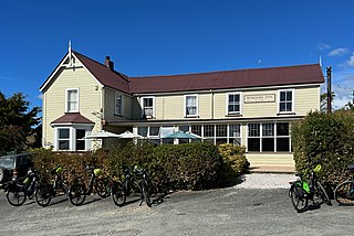
The Moutere Inn is located in Upper Moutere in the Tasman District of New Zealand. It is New Zealand's oldest pub to remain operating in its original building. While there are a couple of older licenses still operating, none of them are operating from either their original location or building.
The Avon River flows northeast from its sources in rough country southwest of Blenheim to reach the Waihopai River 20 kilometres (12 mi) from the latter's outflow into the Wairau River of New Zealand.Tummil River is a tributary of the Avon, joining it southwest of Blenheim.

Marlborough Lines Limited is an electricity distribution company, based in Blenheim, New Zealand. Marlborough Lines is responsible for subtransmission and distribution of electricity to approximately 26,000 customers in the Marlborough Region over a service area of 11,330 km2 (4,370 sq mi). The network includes approximately 3,400 km (2,100 mi) of power lines extending to some very isolated areas across the region, including the extremities of the Marlborough Sounds, which can only be reached by boat or helicopter.

Tokangawhā / Split Apple Rock is a geological rock formation in Tasman Bay / Te Tai-o-Aorere off the northern coast of the South Island of New Zealand. Made of granite from the cretaceous, it is in the shape of an apple which has been cut in half. The cleft to produce two sides of the 'apple' was a naturally occurring joint. Joints occur commonly in granite and are planes of weakness that rain and waves exploit. The traditional Maori myth for the formation describes two gods breaking apart the rock.
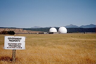
The Waihopai Station is a secure communication facility, located near Blenheim, run by New Zealand's Government Communications Security Bureau. The station started operating in 1989, and collects data that is then shared with New Zealand's allies. In 2021, it was announced that the parts of the station would be deconstructed and removed from the site. Several protests and disputes surrounding its use and the wider implications of the information gathered has gained the facility some local and international notoriety.