Waikawa, Marlborough

Last updated

Waikawa
Waikawa, Marlborough, New Zealand-26October2010.jpg
Waikawa Bay and marina
Waikawa, Marlborough
Coordinates: 41°16′11″S174°2′29″E / 41.26972°S 174.04139°E / -41.26972; 174.04139
CountryNew Zealand
Region Marlborough
Ward
  • Marlborough Sounds General Ward
  • Marlborough Māori Ward
Electorates
Government
  Territorial Authority Marlborough District Council
   Marlborough District Mayor Nadine Taylor
   Kaikōura MP Stuart Smith
   Te Tai Tonga MP Tākuta Ferris
Area
[1]
  Total4.32 km2 (1.67 sq mi)
Population
 (June 2023) [2]
  Total1,700
  Density390/km2 (1,000/sq mi)

Waikawa is a small settlement to the north east of Picton, Marlborough, New Zealand. Waikawa Bay opens onto Queen Charlotte Sound. [3] [4]

Contents

The New Zealand Ministry for Culture and Heritage gives a translation of "bitter water" for Waikawa. [5]

Waikawa is an important New Zealand tourist destination because its large marina acts as gateway to the Marlborough Sounds and famous treks (hikes) such as the Queen Charlotte Track.

Waikawa is host to Waikawa Marina which is one of the largest marinas in New Zealand. Waikawa Marina hosts 600 yacht berths and 70 individual lock-up boatsheds. The marina offers a typical range of modern on-site marine services, supplies, and facilities. These facilities include a café/bar and accommodation.

WaikawaBayPano.jpg
Waikawa Bay, Marlborough

Demographics

Waikawa covers 4.32 km2 (1.67 sq mi) [1] and had an estimated population of 1,700 as of June 2023, [2] with a population density of 394 people per km2.

Historical population
YearPop.±% p.a.
20061,119    
20131,272+1.85%
20181,464+2.85%
Source: [6]

Before the 2023 census, Waikawa had a smaller boundary, covering 3.86 km2 (1.49 sq mi). [1] Using that boundary, Waikawa had a population of 1,464 at the 2018 New Zealand census, an increase of 192 people (15.1%) since the 2013 census, and an increase of 345 people (30.8%) since the 2006 census. There were 609 households, comprising 735 males and 729 females, giving a sex ratio of 1.01 males per female. The median age was 57.4 years (compared with 37.4 years nationally), with 183 people (12.5%) aged under 15 years, 129 (8.8%) aged 15 to 29, 654 (44.7%) aged 30 to 64, and 498 (34.0%) aged 65 or older.

Ethnicities were 88.1% European/Pākehā, 15.4% Māori, 1.6% Pasifika, 1.8% Asian, and 2.3% other ethnicities. People may identify with more than one ethnicity.

The percentage of people born overseas was 18.6, compared with 27.1% nationally.

Although some people chose not to answer the census's question about religious affiliation, 52.0% had no religion, 37.7% were Christian, 1.0% had Māori religious beliefs, 0.4% were Hindu, 0.2% were Muslim, 0.4% were Buddhist and 0.4% had other religions.

Of those at least 15 years old, 183 (14.3%) people had a bachelor's or higher degree, and 270 (21.1%) people had no formal qualifications. The median income was $30,200, compared with $31,800 nationally. 168 people (13.1%) earned over $70,000 compared to 17.2% nationally. The employment status of those at least 15 was that 537 (41.9%) people were employed full-time, 219 (17.1%) were part-time, and 36 (2.8%) were unemployed. [6]

Education

Waikawa Bay School is a coeducational contributing primary (years 1-6) school with a roll of 130 students as of February 2024. [7] [8]

A native school existed at Waikawa Pa by 1877. [9]

Related Research Articles

<span class="mw-page-title-main">Marlborough District</span> District and unitary authority of New Zealand

Marlborough District or the Marlborough Region, commonly known simply as Marlborough, is one of the 16 regions of New Zealand, located on the northeast of the South Island. Marlborough is a unitary authority, both a district and a region. Marlborough District Council is based at Blenheim, the largest town. The unitary region has a population of 52,200.

<span class="mw-page-title-main">Picton, New Zealand</span> Town in Marlborough, New Zealand

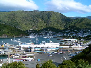
Picton is a town in the Marlborough Region of New Zealand's South Island. The town is located near the head of the Queen Charlotte Sound / Tōtaranui, 25 km (16 mi) north of Blenheim and 65 km (40 mi) west of Wellington. Waikawa lies just north-east of Picton and is considered to be a contiguous part of the Picton urban area.

<span class="mw-page-title-main">Havelock, New Zealand</span> Town in Marlborough, New Zealand

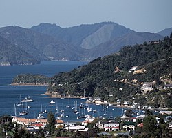
Havelock is a small town in the Marlborough Region of New Zealand, at the head of Pelorus Sound, one of the Marlborough Sounds, and at the mouth of the Pelorus and Kaituna Rivers

<span class="mw-page-title-main">Tokomaru Bay</span> Town in the North Island of New Zealand

Tokomaru Bay is a small beachside community on the remote East Coast of New Zealand's North Island. It is 91 km north of Gisborne, on State Highway 35, and close to Mount Hikurangi. The district was originally known as Toka-a-Namu, which refers to the abundance of sandflies. Over the years the name was altered to Tokomaru Bay.

<span class="mw-page-title-main">Renwick, New Zealand</span> Town in Marlborough, New Zealand

Renwick is a small town in Marlborough, New Zealand, close to the south bank of the Wairau River. It is located on State Highway 6, 12 kilometres (7 mi) west of Blenheim. Havelock is 31 km (19 mi) north. State Highway 63 runs southwest from Renwick through the Wairau River valley.

<span class="mw-page-title-main">Māhia Peninsula</span> Peninsula in Hawkes Bay, New Zealand

Māhia Peninsula is located on the east coast of New Zealand's North Island, in the Hawke's Bay region, between the towns of Wairoa and Gisborne.

<span class="mw-page-title-main">Whangamatā</span> Town in Waikato, New Zealand

The town of Whangamatā is on the southeast coast of the Coromandel Peninsula in the North Island of New Zealand. It is located 30 kilometres north of Waihi, to the north of the western extremity of the Bay of Plenty.

<span class="mw-page-title-main">Opua</span> Place in Northland Region, New Zealand

Opua is a locality in the Bay of Islands, in the sub-tropical Northland Region of New Zealand. It is notable as the first port for overseas yachts arriving in the country after crossing the Pacific Ocean. In the original 1870s plans for the town, it was named Newport. The town of Paihia is nearby, and the small settlement of Te Haumi is in between.

<span class="mw-page-title-main">Māpua, New Zealand</span> Settlement in Tasman District, New Zealand

Māpua is a small town in the South Island of New Zealand. It is to the west of Nelson on State Highway 60 and on the coastline of Tasman Bay.

<span class="mw-page-title-main">Wairau Valley</span> Valley and settlement in Marlborough, New Zealand

Wairau Valley is the valley of the Wairau River in Marlborough, New Zealand and also the name of the main settlement in the upper valley. State Highway 63 runs through the valley. The valley opens onto the Wairau Plain, where Renwick and Blenheim are sited. The Alpine–Wairau Fault runs along the length of the valley.

<span class="mw-page-title-main">Tuamarina</span> Town in Marlborough, New Zealand

Tuamarina is a small town in Marlborough, New Zealand. State Highway 1 runs through the area. The Tuamarina River joins the Wairau River just south of the settlement. Picton is about 18 km to the north, and Blenheim is about 10 km to the south.

<span class="mw-page-title-main">Spring Creek, New Zealand</span> Town in Marlborough, New Zealand

Spring Creek is a small town in Marlborough, New Zealand. State Highway 1 runs past the settlement to the west, and the Wairau River flows past to the east. Picton is 22 km to the north, and Blenheim is 6 km to the south.

<span class="mw-page-title-main">Mayfield, Blenheim</span> Suburb of Blenheim, New Zealand

Mayfield is a suburb to the north of Blenheim's central district, in the Marlborough region of the South Island of New Zealand. Pollard Park and Lansdowne Park are large parks to the west and north of the suburb, and a racecourse lies to the northwest.

Witherlea is a suburb to the south of Blenheim's central district.

<span class="mw-page-title-main">Springlands</span> Suburb of Blenheim, New Zealand

Springlands is a suburb to the west of Blenheim's central district. It is located on and around SH 6, the main road to Renwick. It has a tavern, various takeaways, and a superstore.

<span class="mw-page-title-main">Anakiwa</span> Rural settlement in Marlborough, New Zealand

Anakiwa is a coastal residential village in the Marlborough region of New Zealand. It sits at the head of Queen Charlotte Sound/Tōtaranui, one of the Marlborough Sounds, 23 km (14 mi) west of Picton and 18 km (11 mi) east of Havelock. At the 2018 census, the village had a usual resident population of 171.

<span class="mw-page-title-main">Ōkiwi Bay</span> Rural settlement in Marlborough, New Zealand

Ōkiwi Bay is a small town in the Marlborough Sounds, New Zealand, within Croisilles Harbour. It has about 200 houses and about 80 permanent residents. The area was noted for its oysters.

<span class="mw-page-title-main">Waikawa Beach</span> Settlement in Manawatū-Whanganui, New Zealand

Waikawa Beach is a small settlement in the Horowhenua District of the Manawatū-Whanganui region of New Zealand's North Island. It is located on the South Taranaki Bight at the mouth of Waikawa Stream, 7.5 kilometres northwest of Manakau, and 19 kilometres southwest of Levin, both distances being by road.

<span class="mw-page-title-main">Ngākuta Bay</span> Rural settlement in Marlborough, New Zealand

Ngākuta Bay is a settlement and bay in the Marlborough Sounds, New Zealand. The bay is part of Grove Arm in Queen Charlotte Sound / Tōtaranui. Picton is about 11 km to the southeast via Queen Charlotte Drive. The bay was given its official name of Ngākuta Bay on 27 May 2021 and it has been known as Ngakuta Bay since at least 1865.

<span class="mw-page-title-main">Blenheim Central</span> Central Business District of Blenheim, New Zealand

Blenheim Central is the central suburb and central business district of Blenheim, in the Marlborough region of the South Island of New Zealand. The central park, Seymour Square, contains a clock tower and war memorial fountain.

References

  1. 1 2 3 "ArcGIS Web Application". statsnz.maps.arcgis.com. Retrieved 6 April 2024.
  2. 1 2 "Population estimate tables - NZ.Stat". Statistics New Zealand . Retrieved 25 October 2023.
  3. Peter Dowling, ed. (2004). Reed New Zealand Atlas. Reed Books. pp. map 61. ISBN   0-7900-0952-8.
  4. Roger Smith, GeographX (2005). The Geographic Atlas of New Zealand. Robbie Burton. pp. map 133, 139. ISBN   1-877333-20-4.
  5. "1000 Māori place names". New Zealand Ministry for Culture and Heritage. 6 August 2019.
  6. 1 2 "Statistical area 1 dataset for 2018 Census". Statistics New Zealand. March 2020. Waikawa (Marlborough District) (306700). 2018 Census place summary: Waikawa (Marlborough District)
  7. "New Zealand Schools Directory". New Zealand Ministry of Education. Retrieved 14 March 2024.
  8. Education Counts: Waikawa Bay School
  9. McIntosh, Alister; Redman, William Edward; Allen, William Raymond, eds. (1940). Marlborough: A Provincial History. Blenheim: Marlborough Provincial Historical Committee. p. 345.