Wallaman, Queensland

Last updated

Wallaman
Queensland
Australia Queensland location map.svg
Red pog.svg
Wallaman
Coordinates 18°40′03″S145°51′05″E / 18.6676°S 145.8513°E / -18.6676; 145.8513 Coordinates: 18°40′03″S145°51′05″E / 18.6676°S 145.8513°E / -18.6676; 145.8513
Population0 (2016 census) [1]
 • Density0.000/km2 (0.000/sq mi)
Postcode(s) 4850
Area133.9 km2 (51.7 sq mi)
Time zone AEST (UTC+10:00)
LGA(s) Shire of Hinchinbrook
State electorate(s) Hinchinbrook
Federal Division(s) Kennedy
Suburbs around Wallaman:
Valley Of Lagoons Garrawalt Lannercost
Valley Of Lagoons Wallaman Lannercost
Valley Of Lagoons Mount Fox Upper Stone

Wallaman is a rural locality in the Shire of Hinchinbrook, Queensland, Australia. [2] In the 2016 census, Wallaman had a population of 0 people. [1]

Suburbs and localities are the names of geographic subdivisions in Australia, used mainly for address purposes. The term locality is used in rural areas, while the term suburb is used in urban areas. Australian postcodes closely align with the boundaries of localities and suburbs.

Shire of Hinchinbrook Local government area in Queensland, Australia

The Shire of Hinchinbrook is a local government area in North Queensland, Queensland, Australia. The shire, administered from the town of Ingham, covers an area of 2,810.8 square kilometres (1,085.3 sq mi), and has existed since its creation on 11 November 1879 as one of 74 divisions around Queensland under the Divisional Boards Act 1879.

Queensland North-east state of Australia

Queensland is the second-largest and third-most populous state in the Commonwealth of Australia. Situated in the north-east of the country, it is bordered by the Northern Territory, South Australia and New South Wales to the west, south-west and south respectively. To the east, Queensland is bordered by the Coral Sea and Pacific Ocean. To its north is the Torres Strait, with Papua New Guinea located less than 200 km across it from the mainland. The state is the world's sixth-largest sub-national entity, with an area of 1,852,642 square kilometres (715,309 sq mi).

Geography

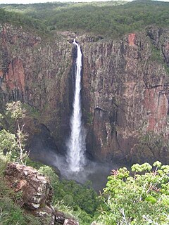
The locality is totally within the Girringun National Park. Wallaman Falls ( 18°35′32″S145°48′05″E / 18.5922°S 145.8014°E / -18.5922; 145.8014 (Wallaman Falls) ) is within both the national park and the locality. [3] The waterfall has a main drop of 268 metres (879 ft), which makes it the country's tallest single-drop waterfall. [4]

Girringun National Park Protected area in Queensland, Australia

Girringun National Park is a national park in Queensland, Australia, approximately 50 kilometres (31 mi) southwest of Ingham, 110 kilometres (68 mi) north of Townsville and 1,290 kilometres (800 mi) northwest of Brisbane. The park is one of the Wet Tropics World Heritage Area series of national parks, and is a gazetted World Heritage site.

Wallaman Falls waterfall in Girringun National Park, Queensland, Australia

The Wallaman Falls, a cascade and horsetail waterfall on the Stony Creek, is located in the UNESCO World Heritage–listed Wet Tropics in the locality of Wallaman, Shire of Hinchinbrook in the northern region of Queensland, Australia. The waterfall is notable for its main drop of 268 metres (879 ft), which makes it the country's tallest single-drop waterfall. The pool at the bottom of the waterfall is 20 metres (66 ft) deep. An estimated 100,000 people visit the waterfall annually.

Related Research Articles

Ingham, Queensland Town in Queensland, Australia

Ingham is a town and locality in the Shire of Hinchinbrook, North Queensland, Australia. It is the administrative centre for the Shire of Hinchinbrook.

Kuranda, Queensland Town in Queensland, Australia

Kuranda is a town and locality on the Atherton Tableland in the Shire of Mareeba, Far North Queensland, Australia. The town of Myola is also located within the locality of Kuranda. It is 25 kilometres (16 mi) from Cairns, via the Kuranda Range road. It is surrounded by tropical rainforest and adjacent to the Wet Tropics World Heritage listed Barron Gorge National Park. It is within the local government area of Shire of Mareeba. In the 2016 census, Kuranda had a population of 3,008 people.
Herbert River river located in Far North Queensland, Australia

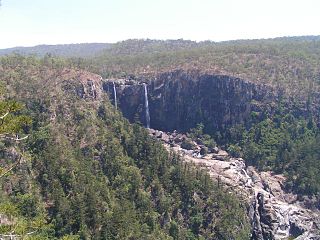
The Herbert River is a river located in Far North Queensland, Australia. The southernmost of Queensland's wet tropics river systems, it was named in 1864 by George Elphinstone Dalrymple explorer, after Robert George Wyndham Herbert, the first Premier of Queensland.

Murray Falls waterfall

The Murray Falls, a cascade waterfall on the Murray River, is located in the UNESCO World Heritage–listed Wet Tropics in Murray Upper, Cassowary Coast Region in the Far North region of Queensland, Australia.

Lucinda, Queensland Town in Queensland, Australia

Lucinda is a coastal town and a locality in the Shire of Hinchinbrook, Queensland, Australia. In the 2016 census, Lucinda had a population of 406 people.

Forrest Beach, Queensland Suburb of Shire of Hinchinbrook, Queensland, Australia

Forrest Beach is a small coastal locality in the Shire of Hinchinbrook, Queensland, Australia, while Allingham is the coastal town within the locality. In the 2016 census, Forrest Beach had a population of 1,254 people.

Halifax, Queensland Town in Queensland, Australia

Halifax is a town and a coastal locality in the Shire of Hinchinbrook, Queensland, Australia. In the 2016 census, Halifax had a population of 462 people.

Minnamoolka, Queensland Suburb of Tablelands Region, Queensland, Australia

Minnamoolka is a locality in the Tablelands Region, Queensland, Australia. In the 2016 census, Minnamoolka had a population of 38 people.

Bloomfield, Queensland Suburb of Shire of Cook, Queensland, Australia

Bloomfield is a town in the Shire of Cook and a coastal locality which is split between the Shire of Cook and the Shire of Douglas in Queensland, Australia. In the 2011 census, Bloomfield had a population of 403 people. The neighbourhood of Ayton is within the locality.

Fishery Falls, Queensland Suburb of Cairns Region, Queensland, Australia

Fishery Falls is a locality in the Cairns Region, Queensland, Australia. In the 2016 census, Fishery Falls had a population of 141 people.

Wangetti, Queensland Town in Queensland, Australia

Wangetti is a coastal town and a locality in the Shire of Douglas, Queensland, Australia. In the 2016 census, Wangetti had a population of 50 people.

Peacock Siding, Queensland Suburb of Shire of Hinchinbrook, Queensland, Australia

Peacock Siding is a rural locality in the Shire of Hinchinbrook, Queensland, Australia. In the 2016 census, Peacock Siding had a population of 94 people.

Coolbie Suburb of Shire of Hinchinbrook, Queensland, Australia

Coolbie is a coastal locality in the Shire of Hinchinbrook, Queensland, Australia. In the 2016 census, Coolbie had a population of 104 people.

Wooroonooran, Queensland Suburb of Cairns Region, Queensland, Australia

Wooroonooran is a locality split among the Cairns Region, the Cassowary Coast Region, and the Tablelands Region in Queensland, Australia. In the 2016 census, Wooroonooran had no population.

Dalrymple Creek, Queensland Suburb of Shire of Hinchinbrook, Queensland, Australia

Dalrymple Creek is a locality in the Shire of Hinchinbrook, Queensland, Australia. In the 2016 census, Dalrymple Creek had a population of 97 people.

Gairloch, Queensland Suburb of Shire of Hinchinbrook, Queensland, Australia

Gairloch is a rural locality in the Shire of Hinchinbrook, Queensland, Australia. In the 2016 census, Gairloch had a population of 41 people.

Hawkins Creek, Queensland Suburb of Shire of Hinchinbrook, Queensland, Australia

Hawkins Creek is a rural locality in the Shire of Hinchinbrook, Queensland, Australia. In the 2016 census, Hawkins Creek had a population of 216 people.

Garrawalt, Queensland Suburb of Shire of Hinchinbrook, Queensland, Australia

Garrawalt is a rural locality in the Shire of Hinchinbrook, Queensland, Australia. In the 2016 census, Garrawalt had a population of 0 people.

Wharps, Queensland Suburb of Shire of Hinchinbrook, Queensland, Australia

Wharps is a rural locality in the Shire of Hinchinbrook, Queensland, Australia. In the 2016 census, Wharps had a population of 0 people.

References

  1. 1 2 Australian Bureau of Statistics (27 June 2017). "Wallaman (SSC)". 2016 Census QuickStats. Retrieved 20 October 2018.
  2. "Wallaman - locality in Shire of Hinchinbrook (entry 42531)". Queensland Place Names. Queensland Government . Retrieved 28 October 2019.
  3. "Queensland Globe". State of Queensland . Retrieved 29 October 2019.
  4. Lloyd, Graham (6 April 2013). "Wild Australia: Legends of the Wallaman falls". The Australian . Retrieved 1 December 2013.