Macknade, Queensland

Last updated

Macknade
Queensland
Population304 (2011 census) [1]
Postcode(s) 4850
Location
LGA(s) Shire of Hinchinbrook
State electorate(s) Hinchinbrook
Federal Division(s) Kennedy
Localities around Macknade:
Rungoo Hinchinbrook Channel Hinchinbrook Channel
Bemerside Macknade Lucinda
Cordelia Cordelia Halifax

Macknade is a town and coastal locality in the Shire of Hinchinbrook, Queensland, Australia. [2] [3]

Contents

Geography

Mackade is bounded by the Herbert River on the south and east, the Seymour River on the west and the Hinchinbrook Channel to the north (separating the mainland from Hinchinbrook Island).

History

Macknade sugar plantation viewed from the Herbert River, 1874 StateLibQld 1 204072 Macknade sugar plantation viewed from the Herbert River, Ingham, 1874.jpg
Macknade sugar plantation viewed from the Herbert River, 1874

The Macknade Sugar Company opened a sugar plantation and the Macknade Sugar Mill in the area in 1874. The district took its name from the mill, which in turn took its name from a house in Kent, England where the mill's owners had lived. [4]

Macknade State School opened on 13 November 1893. [5]

The postal receiving office opened in about 1901 and became a post office in October 1902. The post office closed on 29 October 1993. [6]

In the 2011 census, Macknade had a population of 304 people. [1]

Economy

The Macknade Sugar Mill is situated on the banks of the Herbert River. It is the oldest raw sugar mill in Queensland. Its highest output was in 2005 when it crushed 1.82 million tonnes of sugar cane. [7]

The estuarine location of Macknade is well-suited for sugar growing, but it is also well-suited for aquaculture. Coral Sea Farms on Neames Inlet Road raise both black tiger prawns ( Penaeus monodon ) and barramundi ( Lates calcarifer ). [8]

See also

Related Research Articles

Dimbulah, Queensland Town in Queensland, Australia

,

Cardwell, Queensland Town in Queensland, Australia

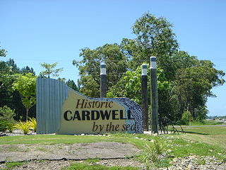
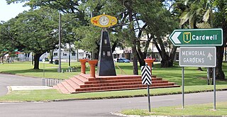
Cardwell is a tropical coastal town and locality in the Cassowary Coast Region in Far North Queensland, Australia. In the 2016 census, Cardwell had a population of 1,309 people. The Bruce Highway National Highway 1 and the North Coast railway line are the dominant transport routes; connecting with the Queensland provincial cities of Cairns and Townsville. Cardwell suffered significant damage from Cyclone Yasi, a category 5 cyclone, in February 2011.

Ingham, Queensland Town in Queensland, Australia

Ingham is a town and locality in the Shire of Hinchinbrook, North Queensland, Australia. It is the administrative centre for the Shire of Hinchinbrook.

Giru, Queensland Town in Queensland, Australia

Giru is a town and coastal locality in the Shire of Burdekin, Queensland, Australia, situated on the Haughton River, 54 kilometres (34 mi) south-east of Townsville. In the 2016 census, Giru had a population of 354 people.

North Queensland Region in Queensland, Australia

North Queensland or the Northern Region is the northern part of the Australian state of Queensland that lies just south of Far North Queensland. Queensland is a massive state, larger than many countries, and its tropical northern part has been historically remote and undeveloped, resulting in a distinctive regional character and identity.

Mossman, Queensland Town in Queensland, Australia

Mossman is a town and a locality in Far North Queensland, Australia, on the Mossman River. It is within the local government area of Shire of Douglas. In the 2016 census, Mossman had a population of 1,937 people.

Lucinda, Queensland Town in Queensland, Australia

Lucinda is a coastal town and a locality in the Shire of Hinchinbrook, Queensland, Australia. In the 2016 census, Lucinda had a population of 406 people.

Shire of Johnstone Local government area in Queensland, Australia

The Shire of Johnstone was a local government area of Queensland. It was located on the Coral Sea coast about 90 kilometres (56 mi) south of the city of Cairns. The shire, administered from the town of Innisfail, covered an area of 1,639.1 square kilometres (632.9 sq mi), and existed as a local government entity from 1881 until 2008, when it amalgamated with the Shire of Cardwell to form the Cassowary Coast Region.

Clare, Queensland Town in Queensland, Australia

Clare is a town and a locality in the Shire of Burdekin, Queensland, Australia.

Brandon, Queensland Town in Queensland, Australia

Brandon is a rural town and locality in the Shire of Burdekin, Queensland, Australia. In the 2016 census, Brandon had a population of 1,094 people.

Mirani, Queensland Town in Queensland, Australia

Mirani is a town and locality in Mackay Region, Queensland, Australia. In the 2016 census, Mirani had a population of 1,541 people.

Wilmar Sugar Australia

Wilmar Sugar Australia is a subsidiary of the Singapore-based company Wilmar International that incorporates sugar production business and renewable energy cogeneration. The principal product of Wilmar Sugar is raw sugar. By-products from the production of sugar include molasses and bagasse. It is Australia’s largest biomass renewable energy generator.

Forrest Beach, Queensland Suburb of Shire of Hinchinbrook, Queensland, Australia

Forrest Beach is a small coastal locality in the Shire of Hinchinbrook, Queensland, Australia, while Allingham is the coastal town within the locality. In the 2016 census, Forrest Beach had a population of 1,254 people.

Halifax, Queensland Town in Queensland, Australia

Halifax is a town and a coastal locality in the Shire of Hinchinbrook, Queensland, Australia. In the 2016 census, Halifax had a population of 462 people.

Trebonne Town in Queensland, Australia

Trebonne is a rural town and locality in the Shire of Hinchinbrook, Queensland, Australia. In the 2016 census, Trebonne had a population of 397 people.

Abergowrie, Queensland Suburb of Shire of Hinchinbrook, Queensland, Australia

Abergowrie is a rural town and locality in the Shire of Hinchinbrook, Queensland, Australia. In the 2016 census, Abergowrie had a population of 438 people.

Minnamoolka, Queensland Suburb of Tablelands Region, Queensland, Australia

Minnamoolka is a locality in the Tablelands Region, Queensland, Australia. In the 2016 census, Minnamoolka had a population of 38 people.

Toobanna, Queensland Town in Queensland, Australia

Toobanna is a town and a locality in the Shire of Hinchinbrook, Queensland, Australia.

Bambaroo, Queensland Suburb of Shire of Hinchinbrook, Queensland, Australia

Bambaroo is a locality in the Shire of Hinchinbrook, Queensland, Australia.

Helens Hill, Queensland Suburb of Shire of Hinchinbrook, Queensland, Australia

Helens Hill is a locality in the Shire of Hinchinbrook, Queensland, Australia.

References

  1. 1 2 Australian Bureau of Statistics (31 October 2012). "Macknade (SSC)". 2011 Census QuickStats. Retrieved 22 May 2014. OOjs UI icon edit-ltr-progressive.svg
  2. "Macknade (town) (entry 20467)". Queensland Place Names. Queensland Government . Retrieved 22 May 2014.
  3. "Macknade (locality) (entry 42522)". Queensland Place Names. Queensland Government . Retrieved 22 May 2014.
  4. "Macknade". Queensland Places. Centre for the Government of Queensland, University of Queensland. Retrieved 22 May 2014.
  5. "Opening and closing dates of Queensland Schools". Queensland Government . Retrieved 22 May 2014.
  6. Premier Postal History. "Post Office List". Premier Postal Auctions. Retrieved 22 May 2014.
  7. "Sucrogen: a sweet story in sugar and renewable energy" (PDF). Burdekin Shire Council . Retrieved 23 May 2014.
  8. "Products". Coral Sea Farms. Retrieved 23 May 2014.

Coordinates: 18°32′25″S146°15′08″E / 18.54028°S 146.25222°E / -18.54028; 146.25222