The Thuringian Forest, is a mountain range in the southern parts of the German state of Thuringia, running northwest to southeast. Skirting from its southerly source in foothills to a gorge on its north-west side is the Werra valley. On the other side of the Forest is an upper outcrop of the North German Plain, the Thuringian Basin, which includes the city Erfurt. The south and south-east continuation of the range is the highland often called the Thuringian-Vogtlandian Slate Mountains.
Sonneberg is a Kreis (district) in the south of Thuringia, Germany. Neighboring districts are the districts Hildburghausen, Saalfeld-Rudolstadt, and the Bavarian districts Kronach and Coburg.
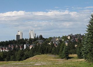
Oberhof is a town in the Schmalkalden-Meiningen district of Thuringia, Germany. Located in the Thuringian Forest mountain range, it is a winter sports center and health resort. With 1,625 inhabitants, it is visited by 144,000 tourists every year (2016). The town obtained its official city status in 1985.

Gräfenthal is a town in the district of Saalfeld-Rudolstadt in Thuringia, Germany.

Lauscha is a town in the district of Sonneberg, in Thuringia, Germany. It is situated 13 km north of Sonneberg, and 24 km southwest of Saalfeld. Lauscha is known for its glassblowing, especially for Christmas tree decorations like baubles.

Lichte is a village and a former municipality in the district of Sonneberg in Thuringia, Germany, close to the Thuringian Rennsteig. Formerly in the district Saalfeld-Rudolstadt, it is part of the town Neuhaus am Rennweg since January 2019.
Lichtetal am Rennsteig is a former municipal association in the district of Saalfeld-Rudolstadt, in Thuringia, Germany. The seat of government was in Lichte. It was disbanded in January 2019.

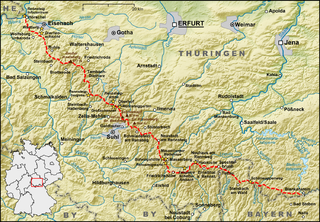
The Rennsteig is a ridge walk as well as an historical boundary path in the Thuringian Forest, Thuringian Highland and Franconian Forest in Central Germany. The long-distance trail runs for about 170 km from Eisenach and the Werra valley in the northwest to Blankenstein and the Selbitz river in the southeast.

Wallendorfer Porzellan or Wallendorf Porcelain is a porcelain manufacturing company which has been in operation since 1764 in Lichte (Wallendorf) in the Thuringian Highlands. Wallendorf is one of the oldest porcelain trademarks in Germany and the whole of Europe.

The Lichte is a right tributary of the Schwarza in Thuringia, Germany, and is 17 kilometres (11 mi) long.
Thuringian Forest Nature Park is one of two nature parks in the state of Thuringia, Germany.
The Mittelberg is an 803.6 m high mountain located in the Thuringian Highland, Thuringia (Germany).
The Hahnberg is a 685.3 m high slightly undulatory tableland located in the Thuringian Highland, Thuringia (Germany).

Peter Hohmann was a merchant and town councillor in Leipzig. He was raised to the peerage and became the founder of the noble lineage Edler of Hohenthal.

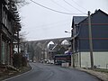
The Lichte (Thuringia) station German: Bahnhof Lichte (Thüringen) was a Deutsche Reichsbahn station in the Thuringian municipality of Lichte in the district of Saalfeld-Rudolstadt. The station is elevated 623 m above Sea Level.

The Lichte (Thuringia) east station was a Deutsche Reichsbahn station of the Thuringian municipality of Lichte (Wallendorf) in the district of Saalfeld-Rudolstadt.
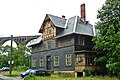
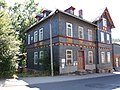
This is a list of the cultural monuments in Lichte containing all cultural monuments of the Thuringian municipality of Lichte / Lichtetal am Rennsteig, including its sections as of December 2, 2009.
The Piesau is a right tributary of the river Lichte in Thuringia, Germany. It is approximately 7 km (4.3 mi) long. The name is derived from the municipality of Piesau.

The Plaue–Themar railway is a 62 kilometre-long, single-track, non-electrified, standard-gauge branch-line in the Thuringian Forest in Germany. The Stützerbach–Schleusingerneundorf section was built as the first Prussian rack railway between 1879 and 1904 and connects the Erfurt–Schweinfurt railway in the north via the towns of Plaue, Ilmenau, Schleusingen and Themar with the Eisenach–Lichtenfels railway in the south.

Görmar is a village and a quarter of the town of Mühlhausen in Thuringia, central Germany.