Walnut Hill, Illinois

Last updated

Walnut Hill, Illinois
Marion County Illinois Incorporated and Unincorporated areas Walnut Hill Highlighted.svg
Location in Marion County, Illinois
Usa edcp location map.svg
Red pog.svg
Walnut Hill
Location in the United States
Coordinates: 38°28′40″N89°2′41″W / 38.47778°N 89.04472°W / 38.47778; -89.04472 [1]
CountryUnited States
StateIllinois
County Marion
Township Centralia
Area
[2]
  Total0.38 sq mi (0.98 km2)
  Land0.38 sq mi (0.98 km2)
  Water0.00 sq mi (0.00 km2)
Elevation
[1]
568 ft (173 m)
Population
 (2020) [3]
  Total95
  Density250.00/sq mi (96.57/km2)
Time zone UTC-6 (CST)
  Summer (DST) UTC-5 (CDT)
ZIP code
62893
Area code 618
FIPS code 17-78604
GNIS ID2400088 [1]
Wikimedia CommonsWalnut Hill, Illinois

Walnut Hill is a village in Marion County, Illinois, United States. The population was 95 at the 2020 census. [3]

Contents

History

Walnut Hill was at one time the intersection of two of the main roads in Illinois: the George Rogers Clark Trace, and the Yadda Road.

The original capital of Illinois was at Kaskaskia, 70 miles (110 km) southwest of present-day Walnut Hill. The overland route from Kaskaskia to the interior of the state followed the Kaskaskia/[[Big Muddy River]] divide, which went through Walnut Hill. George Rogers Clark marched through Walnut Hill in February 1779 on his march from Fort Kaskaskia to Fort Vincennes, which resulted in the conquest of Illinois by the army of Virginia.

Traces of the Kaskaskia/Vincennes road can be seen in several short stretches of road in northwestern Jefferson County, which point toward Walnut Hill, ignoring the surveyed Section boundaries. Northeast of Walnut Hill, the Kell Road is a winding, pioneer road up to its intersection with Interstate 57, from which it follows the modern Section lines to Kell.

Walnut Hill was also on the Goshen Road, an early road across Illinois, from Shawneetown to the Goshen Settlement near Glen Carbon. Remnants of the Goshen Road can be seen in short segments of pioneer road between Dix and Walnut Hill. It is possible that construction of the railroad tracks from Dix to Walnut Hill obliterated much of the original Goshen road.

In 1823, Thomas D. Minor built a road from Mount Vernon to Walnut Hill. This was called the "Vandalia Road", in that it connected with roads to the new state capital in Vandalia. The new road joined the Goshen Road just south of Walnut Hill. Today, it is called the "Old Centralia Road". The new road eventually captured much of the traffic on the Goshen Road, since it provided a shorter route across Jefferson County.

The modern road (Walnut Hill Road) running northwest out of Walnut Hill toward Centralia is the same as the Goshen Road as shown on the original survey maps of Illinois.

William Goings Gang

In the early 19th century, William Goings (also spelled Goins) kept a tavern that was presumably on land homesteaded by Goings about two miles south of Walnut Hill in Jefferson County. Goings led a band of robbers known as the "Goings Gang" that preyed on frontier travelers on the Vincennes-St. Louis Trace, a dirt road that was originally an old bison path that extended through southern Illinois. The gang operated a series of connected frontier taverns along this road, passing information on to gang members whenever a traveler worth robbing stopped at one of their taverns. When the unfortunate traveler reached a remote spot, the gang members would assemble and relieve them of their property.

As in other frontier areas, neighboring settlers overlooked this activity until the Goings Gang escalated to murder in 1818–1819. In response, the settlers organized a group of vigilantes or "rangers" who surprised the Goings Gang at Walnut Hill. The gang members were tied to trees, flogged, and ordered to leave the county, an order which all but one obeyed. The following year, the vigilantes returned and cropped the ears of this obstinate gang member, who may have been criminal gang leader William Goings, possibly because they believed he had no use for his ears as he would not listen and cease in his criminal activities. The tavern site of one of the reported gang members, Samuel Young of Marion County, was excavated by archaeologists working for the Illinois Department of Transportation in 1988 prior to its destruction by a highway project [4]

Geography

Walnut Hill is located in southwestern Marion County. Its southern border is the Jefferson County line. The county boundary is the baseline of the Third Principal Meridian, also called the Centralia Baseline. The survey of this area was begun as early as 1804.[ citation needed ]

Centralia is 7 miles (11 km) to the northwest of Walnut Hill, and Salem, the Marion county seat, is 14 miles (23 km) to the northeast. Mount Vernon, the Jefferson county seat, is 14 miles to the southeast.

According to the U.S. Census Bureau, Walnut Hill has a total area of 0.38 square miles (0.98 km2), all land. [2] To the north of Walnut Hill is Raccoon Creek, a west-flowing tributary of the Kaskaskia River. To the south is the Big Muddy River, a small creek at the northernmost limit of its watershed. Walnut Hill is thus on the Kaskaskia/Big Muddy divide. That divide is a ridge that formed a natural, pioneer highway from Sparta to Kell, perhaps properly called the "Highway to Kell".

Demographics

Historical population
CensusPop.Note
1880 138
1930 125
1940 16028.0%
1950 156−2.5%
1960 153−1.9%
1970 149−2.6%
1980 22349.7%
1990 133−40.4%
2000 109−18.0%
2010 108−0.9%
2020 95−12.0%
U.S. Decennial Census [5]

As of the census [6] of 2000, there were 109 people, 45 households, and 30 families residing in the village. The population density was 294.2 inhabitants per square mile (113.6/km2). There were 50 housing units at an average density of 134.9 per square mile (52.1/km2). The racial makeup of the village was 99.08% White and 0.92% African American.

There were 45 households, out of which 48.9% had children under the age of 18 living with them, 37.8% were married couples living together, 20.0% had a female householder with no husband present, and 33.3% were non-families. 31.1% of all households were made up of individuals, and 28.9% had someone living alone who was 65 years of age or older. The average household size was 2.42 and the average family size was 2.90.

In the village, the population was spread out, with 33.0% under the age of 18, 5.5% from 18 to 24, 35.8% from 25 to 44, 11.0% from 45 to 64, and 14.7% who were 65 years of age or older. The median age was 33 years. For every 100 females, there were 67.7 males. For every 100 females age 18 and over, there were 58.7 males.

The median income for a household in the village was $21,250, and the median income for a family was $30,625. Males had a median income of $26,250 versus $15,417 for females. The per capita income for the village was $9,025. There were no families and 3.9% of the population living below the poverty line, including no under eighteens and 26.7% of those over 64.

Related Research Articles

<span class="mw-page-title-main">Clinton County, Illinois</span> County in Illinois, United States

Clinton County is located in the U.S. state of Illinois. At the 2020 census, the population was 36,899. Its county seat is Carlyle.

<span class="mw-page-title-main">Clay County, Illinois</span> County in Illinois, United States

Clay County is a county in the southeastern portion of the U.S. state of Illinois. As of the 2020 United States Census, the population was 13,288. Since 1842, its county seat has been Louisville, in the center of the county's area.

<span class="mw-page-title-main">Marion County, Illinois</span> County in Illinois, United States

Marion County is a county located in the U.S. state of Illinois. According to the 2020 census, it had a population of 37,729. Its county seat is Salem.

<span class="mw-page-title-main">Jefferson County, Illinois</span> County in Illinois, United States

Jefferson County is a county located in the southern part of the U.S. state of Illinois. According to the 2020 census, it has a population of 37,113. The county seat is Mount Vernon.

<span class="mw-page-title-main">Fayette County, Illinois</span> County in Illinois, United States

Fayette County is a county located in the U.S. state of Illinois. As of the 2020 census, the population was 21,488. Its county seat is Vandalia, the site of the Vandalia State House State Historic Site. Ramsey Lake State Recreation Area is located in the northwestern part of this county.

<span class="mw-page-title-main">Carlyle, Illinois</span> City in Illinois, United States

Carlyle is a city and county seat of Clinton County, Illinois, United States. The population was 3,253 at the 2020 census.

<span class="mw-page-title-main">Centralia, Illinois</span> City in Illinois, United States

Centralia is a city in Clinton, Jefferson, Marion, and Washington counties in the U.S. state of Illinois with the largest portion in Marion County. The city is the largest in three of the counties; Clinton, Marion, and Washington, but is not a county seat of any of them. The population was 12,182 as of the 2020 census, down from 13,032 in 2010.

<span class="mw-page-title-main">Vandalia, Illinois</span> City in Illinois, United States

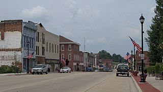
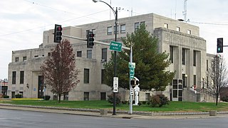
Vandalia is a city in and the county seat of Fayette County, Illinois, United States. At the 2020 Census, the population was 7,458. Vandalia is on the Kaskaskia River, and 60 miles (97 km) northeast of the St. Louis area. The city served as the state capital of Illinois from 1819 until 1839, when the seat of state government moved closer to the center of the state in Springfield. In the early 19th century, Vandalia was the western terminus of the National Road from the East Coast. Since 1933, the Vandalia State House State Historic Site has sought to preserve and interpret the State House building and grounds, originally constructed in 1836.

<span class="mw-page-title-main">Mount Vernon, Illinois</span> City in Illinois, United States

Mount Vernon is a city in and the county seat of Jefferson County, Illinois, United States. The population was 14,600 at the 2020 census. Mount Vernon is the principal city of the Mount Vernon Micropolitan Statistical Area, which includes all of Jefferson and Hamilton counties.

<span class="mw-page-title-main">Central City, Illinois</span> Village in Illinois, United States

Central City is a village in Marion County, Illinois, United States. The population was 1,098 at the 2020 census.

<span class="mw-page-title-main">Junction City, Illinois</span> Village in Illinois, United States

Junction City is a village in Marion County, Illinois, United States. The population was 527 at the 2020 census.

<span class="mw-page-title-main">Kell, Illinois</span> Village in Illinois, United States

Kell is a village in Marion County, Illinois, United States. The population was 173 at the 2020 census, down from 219 in 2010.

<span class="mw-page-title-main">Patoka, Illinois</span> Village in Illinois, United States

Patoka is a village in Marion County, Illinois, United States. The population was 525 at the 2020 census.

<span class="mw-page-title-main">Sandoval, Illinois</span> Village in Illinois, United States

Sandoval is a village in Marion County, Illinois, United States. The population was 1,157 at the 2020 census.

<span class="mw-page-title-main">Vernon, Illinois</span> Village in Illinois, United States

Vernon is a village in Marion County, Illinois, United States. The population was 103 at the 2020 census.

<span class="mw-page-title-main">Fillmore, Illinois</span> Village in Illinois, United States

Fillmore is a village in Montgomery County, Illinois, United States. The population was 305 at the 2020 census.

<span class="mw-page-title-main">Taylor Springs, Illinois</span> Village in Illinois, United States

Taylor Springs is a village in Montgomery County, Illinois, United States. The population was 724 at the 2020 census.

Goshen Road was an early road that ran from Old Shawneetown, Illinois, on the Ohio River, northwest to the Goshen Settlement, near Glen Carbon, Illinois, near the Mississippi River. In the early 19th century, this was the main east/west road in Illinois.

<span class="mw-page-title-main">Columbia metropolitan area (Missouri)</span> Metropolitan area in Missouri, United States

The Columbia metropolitan area is the region centered around the City of Columbia in the U.S. state of Missouri. Located in Mid-Missouri, it consists of five counties: Boone, Audrain, Randolph, Cooper, and Howard. The population was estimated at 256,640 in 2017, making it the 4th largest metropolitan area in Missouri. Columbia is home to the University of Missouri, and is Missouri's fourth most-populous and fastest growing city, with an estimated 121,717 residents as of 2017. Other significant cities in the area include Moberly, Mexico, Boonville, Vandalia, Centralia, and Fayette.

<span class="mw-page-title-main">Vandalia Township, Fayette County, Illinois</span> Township in Illinois, United States

Vandalia Township is one of twenty townships in Fayette County, Illinois, USA. As of the 2020 census, its population was 6,364 and it contained 3,069 housing units.

References

  1. 1 2 3 U.S. Geological Survey Geographic Names Information System: Walnut Hill, Illinois
  2. 1 2 "2022 U.S. Gazetteer Files: Illinois". United States Census Bureau. Retrieved February 27, 2023.
  3. 1 2 "P1. Race – Walnut Hill village, Illinois: 2020 DEC Redistricting Data (PL 94-171)". U.S. Census Bureau. Retrieved February 27, 2023.
  4. The Archaeology of the Old Landmark, Mark J. Wagner and Mary R. McCorvie, 1992
  5. "Census of Population and Housing". Census.gov. Retrieved June 4, 2015.
  6. "U.S. Census website". United States Census Bureau . Retrieved January 31, 2008.