Cadillac is a city in and county seat of Wexford County in the U.S. state of Michigan. The population was 10,371 at the 2020 census, making it the second most-populated city in the Northern Michigan region, after Traverse City.

Wexford County is a county in the Northern Lower Peninsula of the U.S. state of Michigan. As of the 2020 United States census, the population was 33,673. The seat of Wexford County is Cadillac, which is also the county's largest city.

Grand Traverse County is a county located in the U.S. state of Michigan. As of the 2020 census, the population was 95,238, making it the largest county in Northern Michigan. Its county seat is Traverse City. The county is part of the Traverse City metropolitan area, which also includes neighboring Benzie, Kalkaska, and Leelanau counties.
Petoskey is a city in the U.S. state of Michigan. It is the county seat of Emmet County, and is the largest settlement within the county. Petoskey has a population of 5,877 at the 2020 census, up from 5,670 at the 2010 census.

Fife Lake is a village in southeastern Grand Traverse County in the U.S. state of Michigan. Its population was 456 at the 2020 census, up from 443 at the 2010 census. The village is part of the Traverse City metropolitan area, and lies upon the shore of the lake of the same name.

Fife Lake Township is a civil township of Grand Traverse County in the U.S. state of Michigan. As of the 2020 census, the township population was 1,526, a slight increase from 1,517 at the 2000 census. The village of Fife Lake is located within the township.

Whitewater Township is a civil township of Grand Traverse County in the U.S. state of Michigan. The population was 2,688 at the 2020 census, an increase from 2,597 at the 2010 census. Whitewater Township includes shores on Elk Lake and Lake Skegemog, two large lakes in the Chain of Lakes. A portion of the township is within the Grand Traverse Indian Reservation.
Kalkaska is a village in the U.S. state of Michigan. Kalkaska is the county seat and only incorporated community of Kalkaska County, and is considered part of Northern Michigan. Its population was 2,132 at the 2020 census, an increase from 2,020 at the 2010 census.
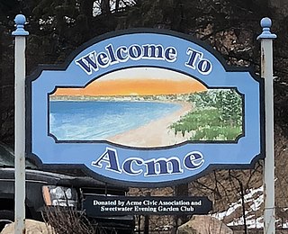
Acme is an unincorporated community in Grand Traverse County in the U.S. state of Michigan. It is located on the shore of the East Arm of Grand Traverse Bay, located within Acme Township. It is part of the urban area of Traverse City. Acme is home to the Grand Traverse Resort & Spa.
The Leelanau Peninsula is a peninsula of the U.S. state of Michigan that extends about 30 miles (50 km) from the western side of the Lower Peninsula of Michigan into Lake Michigan, forming Grand Traverse Bay. It is often referred to as the "little finger" of the mitten-shaped lower peninsula. The peninsula is a tourist hotspot, especially due to the popularity of Sleeping Bear Dunes National Lakeshore, which adorns the southwestern coast of the peninsula. The peninsula is also largely agricultural, and is a production hotspot for cherries and wine.

Interlochen is an unincorporated community and census-designated place (CDP) in Grand Traverse County in the U.S. state of Michigan. At the 2020 census, the population was 694, up from 583 at the 2010 census. The community is located within Green Lake Township, and is home to a post office operating with ZIP Code 49643.
Mayfield is an unincorporated community in Grand Traverse County in the U.S. state of Michigan. It is located in Paradise Township between Kingsley and Traverse City along South Garfield Road. As an unincorporated community, Mayfield has no legally defined boundaries or population statistics of its own.
Williamsburg is an unincorporated community in the U.S. state of Michigan. The community is located in Whitewater Township, Grand Traverse County. The community is home to Turtle Creek Casino and Hotel.

Sherman is an unincorporated community in Wexford County in the U.S. state of Michigan.

Northern Michigan, also known as Northern Lower Michigan, is a region of the U.S. state of Michigan. A popular tourist destination, it is home to several small- to medium-sized cities, extensive state and national forests, lakes and rivers, and a large portion of Great Lakes shoreline. The region has a significant seasonal population much like other regions that depend on tourism as their main industry. Northern Lower Michigan is distinct from the more northerly Upper Peninsula and Isle Royale, which are also located in "northern" Michigan. In the northernmost 21 counties in the Lower Peninsula of Michigan, the total population of the region is 506,658 people.
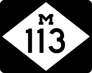
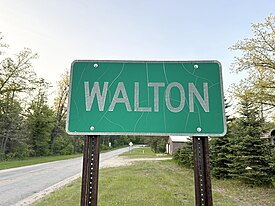
M-113 is a state trunkline highway in the US state of Michigan that runs in southern Grand Traverse County, connecting M-37 in Mayfield Township to US Highway 131 (US 131) near Walton Junction. Running through rural farmland and dense woodland, M-113 provides access to the village of Kingsley, as well as offering a route from US 131 to Traverse City. First designated in November 1927, the highway was extended in 1940 by adding the southernmost section near Walton Junction, which was originally part of US 131.

M-119 is a 27.548-mile (44.334 km) state trunkline highway entirely within Emmet County in the US state of Michigan. The highway follows the shore of Lake Michigan and the Little Traverse Bay, with its southern terminus at US Highway 31 (US 31) near Bay View, about four miles (6.4 km) east of Petoskey; the northern terminus is at a junction with county roads C-66 and C-77 in Cross Village. North of Harbor Springs, the highway is known as the Tunnel of Trees Scenic Heritage Route. This section of highway lacks a centerline and is known for its scenic beauty. On an average day, between 2,000 and 15,000 vehicles use various parts of the highway.

M-186 is a state trunkline highway in the US state of Michigan. Entirely within Fife Lake Township, in southeastern Grand Traverse County, the highway serves as a short connector between M-113 near Kingsley and US Highway 131 (US 131) at the village of Fife Lake. The current incarnation of M-186 is the second usage of the designation, as it was originally used for a highway in Delta County in the 1930s.

US Highway 131 (US 131) is a north–south United States Highway, of which all but 0.64 of its 269.96 miles are within the state of Michigan. The highway starts in rural Indiana south of the state line as a state road connection to the Indiana Toll Road. As the road crosses into Michigan it becomes a state trunkline highway that connects to the metropolitan areas of Kalamazoo and Grand Rapids before continuing north to its terminus at Petoskey. US 131 runs as a freeway from south of Portage through to Manton in the north. Part of this freeway runs concurrently with Interstate 296 (I-296) as an unsigned designation through Grand Rapids. US 131 forms an important corridor along the western side of the Lower Peninsula of Michigan, running through rural farm and forest lands as well as urban cityscapes. Various names have been applied to the roadway over the years. The oldest, the Mackinaw Trail, originated from an Indian trail in the area while other names honored politicians. An attempt to dedicate the highway to poet James Whitcomb Riley failed to gain official support in Michigan.
Bingham Township is a civil township of Leelanau County in the U.S. state of Michigan. As of the 2020 census, the township population was 2,577. The township is named for Kinsley S. Bingham, a U.S. Representative, U.S. Senator, and Governor of Michigan.