Walton, Milton Keynes

Last updated

Walton
Walton hall.JPG
Walton Hall, the former manor house of Walton.
Location map United Kingdom Milton Keynes.png
Red pog.svg
Walton
Buckinghamshire UK location map.svg
Red pog.svg
Walton
Location within Buckinghamshire
Population12,100 (2021 Census) [1]
OS grid reference SP854388
Civil parish
  • Walton
Unitary authority
Ceremonial county
Region
Country England
Sovereign state United Kingdom
Post town MILTON KEYNES
Postcode district MK7
Dialling code 01908
Police Thames Valley
Fire Buckinghamshire
Ambulance South Central
UK Parliament
List of places
UK
England
Buckinghamshire

52°01′00″N0°42′01″W / 52.0166°N 0.7002°W / 52.0166; -0.7002

Contents

Walton, Milton Keynes

Walton was historically a hamlet and now a district and civil parish in Milton Keynes, Buckinghamshire, England. [2] For local government purposes, it is part of the Danesborough and Walton electoral ward.

The historic hamlet is located about four miles south of Central Milton Keynes and just east of Simpson, mostly along Walton Road in the modern Walnut Tree district. The modern H9 Groveway grid road severs a few of its houses into Walton Hall and the V10 Brickhill Street separates the Manor Farm off into the Walton grid square. The Manor Farm has been redeveloped, first into a research centre for Hoechst and subsequently as the UK headquarters of MSD Animal Health. [3]

The village name is a common one in England, and is an Old English language word, meaning either 'village of the Britons' (wale being a word meaning Briton) or 'walled village'. The village is first recorded (in the 12th century) as Wauton. [4]

Walton Hall, the manor house of the village, and its chapel of ease (now deconsecrated) are in the campus grounds of The Open University, in the Walton Hall district.

Modern Walton

The modern Walton district is a light-industrial and residential district on the banks of the River Ouzel, a tributary of the Great Ouse and on the other side of Brickhill Street from the hamlet that gives it its name. It is largely the grounds of Walton Manor Farm. The other village farm, Walnut Tree Farm, still exists and the Walnut Tree district is on its lands.

Walton Civil Parish

The civil parish of Walton includes the districts of Browns Wood, Caldecotte, Old Farm Park, Tilbrook, Towergate, Walton, Walton Hall, Walton Park, Walnut Tree and Wavendon Gate. Caldecotte Lake is one of the more significant geographic features, extending from Caldecotte and Walton Park. The Parish Council is entitled a 'Community Council".

Walton Community Council is the first tier of local government serving those living, attending and working in this area of Milton Keynes. The Community Council is responsible for the estates and villages of Browns Wood, Caldecotte, Old Farm Park, Tilbrook, Tower Gate, Walnut Tree, Walton Hall, Walton Park and Wavendon Gate.

Browns Wood

Browns Wood is a district in the south-east corner of the civil parish which, in the 2001 Census, also gave its name to an Office for National Statistics designated 'urban sub-area'.

The Sports Ground at Browns Wood contains 2 football pitches, a pump track, children's play area, outdoor gym and a Multi Use Games Area (MUGA) which is open access but can be hired from the Walton Community Council.

Caldecotte

Caldecotte Lake Business Park Caledcotte business park.jpeg
Caldecotte Lake Business Park

Caldecotte (pronounced Cold-e-cot) is another district in the parish, that includes the site of an ancient village of the same name. It is also includes the larger part of Caldecotte Lake, an important manmade balancing lake that manages flood water on the River Ouzel just as it enters Milton Keynes. The lake is used by a number of local clubs for rowing and other water sports.

The place name is fairly common in England, and is Old English meaning "cold cottage". This refers to a resting place for travellers or other strangers on the road. The original Northampton to London road (modern Brickhill Street) runs nearby, just short of its junction with Watling Street (itself a major route in continuous use since Roman times). The village declined when the Northampton road was rerouted in 1728 through Broughton and Woburn to join the Watling Street at Hockliffe.

Old Farm Park

Old Farm Park is a residential area in the south-east of the parish.

Tilbrook

The Red Bull Technology factory in Tilbrook, home of Red Bull Racing since 2004. Red Bull Racing factory south-west.jpg
The Red Bull Technology factory in Tilbrook, home of Red Bull Racing since 2004.

The industrial area of Tilbrook is noted for being the home of Red Bull Racing.

Walton (district)

Walton itself is to the north-west of the parish, contained by Groveway, Brickhill Street, Bletcham Way and the River Ouzel. Walton contains a research centre for Hoechst AG as well as housing.

Walton Hall

Robert Hooke building located on the Open University campus. Robert Hook building at Open University Campus in Milton Keynes, spring 2013 (1).JPG
Robert Hooke building located on the Open University campus.

Walton Hall is in the northwest of the parish, and is the location of the campus and offices of The Open University. [5] The university campus covers 45 hectares (110 acres) [6]

In the university campus grounds are the manor house (Walton Hall), which gives the district its name, and the ancient chapel of ease of St Michael, now deconsecrated. [7] The manor farm-lands are divided between Walton Hall, the modern Walton, Kents Hill and Walnut Tree.

The manor house itself, built in 1830 in the Regency style for the Pinfold family, [7] is home to the vice-chancellor's offices of the Open University. [8]

Walton Hall is on the banks of the Ouzel, a tributary of the Great Ouse where Walton Lake, a small balancing lake, has become naturalised and is home to reeds, bulrushes, reed warbler, reed bunting, water rail, sparrowhawk, kestrel, green woodpecker, grass snake and many varieties of odonata. [9] Surrounding the reedbed are ponds and open water, ancient hedgerows and hay meadow.

Walnut Tree

Heronsgate School, Walnut Tree Heronsgate Junior School, Walnut Tree - geograph.org.uk - 731148.jpg
Heronsgate School, Walnut Tree

Walnut Tree is a residential district in Walton, with a population of 3,354 in the last UK census. [10] It is named after the Walnut Tree Farm, on whose land the estate was built. All the street names in Walnut Tree are named after either wild flowers and herbs or 18th century turnpike trusts. [11]

Walnut Tree is home to a local centre, including small shopping outlets and takeaway restaurants. The district also contains the Blackberry Sports Injury Clinic [12] and a GP surgery. Walnut Tree also has a pub, The Tawny Owl, and a pet supplies business [13] based on Walnut Tee Farm.

The area features three schools, all operated by the Milton Keynes Education Trust (MKET) [14] Walton High for secondary education as well as the Heronshaw and Heronsgate schools [15] for primary education, serving both Key Stage 1 and Key Stage 2 respectively.

There is a cricket ground and football pitch with changing facilities. There are a number of play parks for children scattered throughout the area.

Wavendon Gate

Wavendon Gate is a district within the civil parish which borders the village of Wavendon. It is a mainly residential area which contains the Wavendon Gate junior school [16] and also a cricket green and pavilion [17] for recreational activities.

ONS Urban Sub-Areas

For the 2001 Census, the Office for National Statistics designated urban sub-areas called Walnut Tree and Browns Wood that are far bigger than the districts of that name. [18] The Walnut Tree and Browns Wood urban sub-areas together approximated to that part of the former Newport Pagnell Rural District that is west of the River Ouzel and east of the M1. The ONS discontinued this usage in the 2011 Census.

Related Research Articles

<span class="mw-page-title-main">Milton Keynes</span> City in Buckinghamshire, England

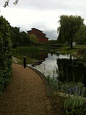
Milton Keynes is a city in Buckinghamshire, England, about 50 miles (80 km) north-west of London. At the 2021 Census, the population of its urban area was 264,349. The River Great Ouse forms the northern boundary of the urban area; a tributary, the River Ouzel, meanders through its linear parks and balancing lakes. Approximately 25% of the urban area is parkland or woodland and includes two Sites of Special Scientific Interest (SSSIs).

<span class="mw-page-title-main">City of Milton Keynes</span> Unitary authority area in England

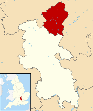
The City of Milton Keynes is a unitary authority area with both borough and city status, in Buckinghamshire. It is the northernmost district of the South East England Region. The borough abuts Bedfordshire, Northamptonshire and the remainder of Buckinghamshire.

Woughton is a civil parish in south central Milton Keynes, Buckinghamshire, England. The parish council uses the term Community Council.

<span class="mw-page-title-main">Bletchley</span> Human settlement in England

Bletchley is a constituent town of Milton Keynes, Buckinghamshire, England. It is situated in the south-west of the city, and is split between the civil parishes of Bletchley and Fenny Stratford and West Bletchley. In 2011, the two parishes had a combined population of 37,114.

<span class="mw-page-title-main">Broughton, Milton Keynes</span> Civil parish in Milton Keynes, England

Broughton is a historic village, modern district and civil parish in Milton Keynes, Buckinghamshire, England, approximately 3 miles (4.8 km) east of Central Milton Keynes. It is governed by Broughton and Milton Keynes Joint Parish Council, shared with the neighbouring Milton Keynes parish. Broughton district was developed during the 2000s and 2010s largely to the south and east of the historic village.

<span class="mw-page-title-main">Middleton, Milton Keynes</span> Area of Milton Keynes, England

Middleton is an area of Milton Keynes, a city in Buckinghamshire, England, and part of the civil parish of Milton Keynes. Its historic centre is Milton Keynes Village, the village that in 1967 gave its name to the city of which it is now a small part. It is delineated by Childs Way to the north, Tongwell Street to the east, Chaffron Way to the south and Brickhill Street to the west. The River Ouzel runs diagonally through it, from west to north.

<span class="mw-page-title-main">Great Linford</span> Civil parish in Milton Keynes, England

Great Linford is a historic village, district and wider civil parish in the north of Milton Keynes, England, between Wolverton and Newport Pagnell, and roughly 2 miles (3.2 km) north of Central Milton Keynes.

<span class="mw-page-title-main">Simpson, Milton Keynes</span> Human settlement in England

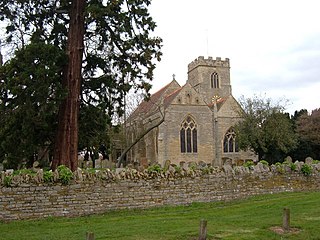
Simpson is a village in Milton Keynes, England. It was one of the villages of historic Buckinghamshire that was included in the "New City" in 1967. It is located south of the centre, just north of Fenny Stratford.

<span class="mw-page-title-main">Wavendon</span> Human settlement in England

Wavendon is a village and civil parish in the south east of the Milton Keynes urban area, in Buckinghamshire, England.

<span class="mw-page-title-main">Woburn Sands</span> Human settlement in England

Woburn Sands is a town that straddles the border between Buckinghamshire and Bedfordshire in England, and is part of the Milton Keynes urban area. The larger part of the town is in Woburn Sands civil parish, which is in the City of Milton Keynes, Smaller parts of the town are in the neighbouring parishes of Aspley Guise and Aspley Heath. The meandering boundary between Buckinghamshire and Bedfordshire means the Lower and Middle Schools that serve all of the town are both in Aspley Guise CP. Bedfordshire Police and Thames Valley Police both deal with law enforcement issues in the town. At the 2011 Census, the population of the civil parish (only) was 2,916, that of the built-up area was 5,959. Woburn Sands, Aspley Guise and Aspley Heath each has its own centre but together the three settlements are a contiguous built-up area.

Kents Hill, Monkston and Brinklow is a civil parish that covers the Kents Hill, Brinklow, Monkston, Monkston Park and Kingston districts of Milton Keynes in Buckinghamshire, England. As the first tier of Local Government, the Parish Council is responsible for the people, living and working in this area of Milton Keynes.

<span class="mw-page-title-main">Milton Keynes redway system</span> Shared path network in Milton Keynes, England

The Milton Keynes redway system is an over 200 miles network of shared use paths for cyclists and pedestrians in Milton Keynes, Buckinghamshire, England. It is generally surfaced with red tarmac, and criss-crosses most of the city.

<span class="mw-page-title-main">History of Milton Keynes</span> History of the city in England

This history of Milton Keynes details its development from the earliest human settlements, through the plans for a 'new city' for 250,000 people in northern Southeast England, its subsequent urban design and development, to the present day. Milton Keynes, founded in 1967, is the largest settlement and only city in Buckinghamshire. At the 2021 census, the population of its urban area was estimated to have exceeded 256,000.

<span class="mw-page-title-main">MK Metro</span> Bus line based in Milton Keynes, Buckinghamshire

MK Metro was a bus company operating in Milton Keynes from 1997 until 2010.

<span class="mw-page-title-main">Milton Keynes grid road system</span> Top layer of street hierarchy

The Milton Keynes grid road system is a network of predominantly national speed limit, fully landscaped routes that form the top layer of the street hierarchy for both private and public transport in Milton Keynes, Buckinghamshire. The system is unique in the United Kingdom for its innovative use of street hierarchy principles: the grid roads run in between districts rather than through them. This arrangement permits higher speed limits due to the absence of buildings close to the roads – although more recently some have been limited in part to 40 mph (64 km/h). The grid road system also serves an important purpose of discouraging through-traffic from travelling through neighbourhoods and thus reduces traffic noise and pollution in pedestrian areas. Motor traffic is segregated from pedestrian and leisure cycling traffic, which uses the alternative Milton Keynes redway system. Almost all grid junctions are roundabouts, and the absence of traffic lights enables free and efficient movement of traffic.

Oakgrove is a district of Milton Keynes in Buckinghamshire, England, in the civil parish of Milton Keynes. The district includes a small retail centre consisting of a Waitrose Supermarket, a Metro Bank branch, and other small services units. A large portion of the district is reserved as linear park to accommodate the flood plain of the river Ouzel, a tributary of the river Great Ouse.

<span class="mw-page-title-main">Old Woughton</span> Civil parish in Milton Keynes, England

Old Woughton is a district and civil parish in south central Milton Keynes, Buckinghamshire, England. The parish was established in April 2012 by the division into two parts of Woughton parish. The original (undivided) civil parish was itself originally called "Woughton on the Green".

<span class="mw-page-title-main">Loughton and Great Holm</span> Civil parish in Milton Keynes, England

Loughton and Great Holm is a civil parish in the City of Milton Keynes, Buckinghamshire, England. It includes the districts of Loughton, Great Holm, the National Bowl and Elfield Park, West Rooksley, Loughton Lodge, and Knowlhill. It is bordered by H4 Dansteed Way to the north, V4 Watling Street to the west, a tiny stretch of H8 Standing Way to the south, and the West Coast Main Line to the east. Originally named Loughton, it was renamed to Loughton and Great Holm in 2013

Campbell Park is a civil parish in Milton Keynes, Buckinghamshire, England. The parish is bounded by Childs Way (H6) to the north, the River Ouzel to the east, the A5 to the west, and Chaffron Way to the south. The parish includes the § Fishermead, § Newlands, § Oldbrook, § Springfield, § Winterhill, Willen and The Woolstones grid-squares. The parish was originally known as Woolstone-cum-Willen, and was formed on 1 April 1934 as a merger of Great Woolstone, Little Woolstone and Willen. The parish was part of Newport Pagnell Rural District until the latter became part of the Borough of Milton Keynes in 1974. The parish was redefined in 2012, when the districts of Campbell Park (sic), Newlands and Willen were reallocated to other parishes. Despite the loss of its eponymous district, the Parish Council continues to use its name. As of December 2022, the parish council is consulting on changing its name.

References

  1. "Walton". Office for National Statistics. Retrieved 22 April 2024. (ONS area excludes Walton
  2. "Contact your parish, town or community council". Milton Keynes Council. 23 October 2020. Archived from the original on 23 October 2020. Retrieved 27 October 2020.
  3. "MSD Animal Health receives 'breakthrough of the year' award for EXZOLT® at BFREPA conference". 12 October 2018. Archived from the original on 30 October 2020. Retrieved 27 October 2020. Intervet UK Ltd trading as MSD Animal Health. Registered office Walton Manor, Walton
  4. Page, William, ed. (1927). "Parishes : Walton". A History of the County of Buckingham. Victoria History of the Counties of England. Vol. 4. London: Constable & Co. Ltd. pp. 485–489.
  5. "Milton Keynes Campus". The Open University.
  6. "Biodiversity at Walton Hall Campus". Estates Division, The Open University. 19 December 2016. Retrieved 12 March 2023.
  7. 1 2 Page, William, ed. (1927). "Parishes : Walton". A History of the County of Buckingham. Victoria History of the Counties of England. Vol. 4. London: Constable & Co. Ltd. pp. 485–489. A church existed here in 1225, but the structure of that period was entirely rebuilt about the middle of the 14th century, the date of the present chancel and nave.
  8. Woodfield, Paul (1986). A guide to the historic buildings of Milton Keynes. Milton Keynes: Milton Keynes Development Corporation. ISBN   978-0903379052.
  9. "Walton Lake". The Parks Trust. 2021.
  10. "Walnut Tree (pdf)" (PDF). Archived (PDF) from the original on 26 November 2021. Retrieved 29 September 2012.
  11. Anne Baker – Street Names of Milton Keynes East ISBN   978-1-86077-411-9
  12. "Contact". Archived from the original on 31 October 2020. Retrieved 27 October 2020.
  13. "Walnut Pet Supplies - Pet Shop, Cat Food, Dog Food, Milton Keynes". Archived from the original on 28 November 2012. Retrieved 29 September 2012.
  14. "Our Schools". www.mket.org.uk. Archived from the original on 3 August 2020. Retrieved 26 June 2020.
  15. "Welcome". Archived from the original on 23 October 2012. Retrieved 29 September 2012.
  16. "Wavendon Gate School". Archived from the original on 3 March 2016. Retrieved 29 September 2012.
  17. "Wavendon Gate Pavilion - Home". www.wavendongatepavilion.com. Archived from the original on 15 April 2012. Retrieved 29 September 2012.
  18. KS01 Usual resident population: Census 2001, Key Statistics for urban areas Archived 20 August 2011 at the Wayback Machine (lines 1808 to 1815).

See also

Commons-logo.svg Media related to Walton, Milton Keynes at Wikimedia Commons