Walton Well Road

Last updated

Looking east along Walton Well Road from the canal bridge. Looking west along Walton Well Road, Oxford.JPG
Looking east along Walton Well Road from the canal bridge.
The "Elijah terrace" houses on the south side of Walton Well Road. Houses on Walton Well Road, Oxford.JPG
The "Elijah terrace" houses on the south side of Walton Well Road.
View east along Walton Well Road close to the junction with Southmoor Road and Longworth Road. Walton Well Road, Oxford.JPG
View east along Walton Well Road close to the junction with Southmoor Road and Longworth Road.

Walton Well Road is a road, about 400 metres (a quarter mile) long, near the centre of Oxford, England. It provides a link from central Oxford to Port Meadow.

Contents

Location

The road marks the northern edge of the district known as Jericho. At the eastern end is the north end of Walton Street and the south end of Kingston Road at the junction with St Bernard's Road. The western end is reached by a bridge (Walton Well Road Bridge) spanning the Oxford Canal and also the railway line. Here there is access to Port Meadow and the Thames Path, with a car park run by Oxford City Council. [2] About halfway along the road is a junction with Longworth Road and Southmoor Road. To the south, between the canal and the railway line, a new residential road, William Lucy Way, was developed around 2006, [3] on the other side of the Oxford Canal from the former Lucy's Eagle Ironworks site. To the south are modern residential apartments on the site of the Eagle Ironworks, St Sepulchre's Cemetery and beyond that Juxon Street.

The Oxford-Man Institute of Quantitative Finance, a research institute of the University of Oxford established in 2007, is located at Eagle House in Walton Well Road. [4] [5]

Spring

Former fountain on Walton Well Road. Former fountain on Walton Well Road - geograph.org.uk - 1760230.jpg
Former fountain on Walton Well Road.

The road is on the site of a spring known as Walton Well [6] (or Bruman's Well) [7] At the location of the spring, there is a drinking fountain in the road, with a plaque dated 1885. [7] It was erected by William Ward, who was Mayor of Oxford in 1851 and 1861. [8] The fountain was designed by the architect Harry Wilkinson Moore and carved in Portland stone by McCulloch of London. [9]

History

The road is important historically because not only did it lead to Port Meadow, but it was also used as a short cut to Binsey, Medley, and Wytham via a ford, called Walton Ford [10] or Walton Well Ford. [11]

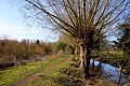
The Oxford Canal reached the outskirts of Oxford in 1789, when a coal wharf was opened at Heyfield Hutt, now the site of Hayfield Road to the north of Walton Well Road. The final section into central Oxford was ceremonially opened on 1 January 1790; it needed a bridge to be built over it to maintain the link to Port Meadow. The canal led to the industrialization of the area. In the 19th century, there was a basin and Walton Well hard for boats from the canal at Walton Well Road near the junction with Longworth Road. [12]

On the south side of the street for many years was the historic Eagle Ironworks (aka Lucy's), first established on this site by the Oxford Canal in 1825. [13] The area has now been redeveloped as flats by Berkeley Homes, [14] after an archaeological evaluation. [15] During the archaeological excavation, a 17th-century pit and a possible 19th-century well were discovered to the rear of 25 Walton Well Road.

View of the Cherwell Valley line railway north from Walton Well Road. Passing Voyagers - geograph.org.uk - 221498.jpg
View of the Cherwell Valley line railway north from Walton Well Road.

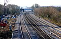
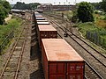
The Cherwell Valley line railway next to the Oxford Canal was opened in 1850. In this decade, a railway station was planned at Walton Well. [16] A railway line to Brentford in west London was proposed by the Oxford, Worcester and Wolverhampton Railway from this station, across the parish of St Giles, just north of the present Bevington Road and Norham Gardens. The plan never materialized.

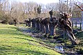
The houses on Walton Well Road were built between 1873 and 1897. [17] Many were designed by the architect H. W. Moore (who also designed the fountain in the street mentioned earlier) in the 1880s, some in collaboration with William Wilkinson. [9] No. 2 Walton Well Road, an imposing double-fronted residence, was the house of the ironmaster at the adjacent Lucy's foundry. [18] On the south side of the street is the "Elijah terrace", a row of terraced houses built by Joseph Codgbrook Curtis. [1] These include nine carved panels by the local sculptor Samuel Grafton, based in Cowley Road, Oxford, on aspects of the biblical story of the prophet Elijah in the Old Testament.

During the early 20th century, the poet and short story writer A. E. Coppard (1878–1957) had a clerical post at the Eagle Ironworks in Walton Well Road, as recounted in his autobiography It's Me, O Lord! [19]

Also in Walton Well Road was the Catholic Workers College (at No. 2) from 1921 until 1955 when it moved to Boar's Hill south of Oxford and was renamed Plater College. [18]

Squatters moved into the area during the 1960s and 1970s, and were dubbed 'Waltons'. [20]

Around 2000, The Waterways estate was built on the site of the British Motor Corporation's former Osberton Radiator Factory immediately to the north of Walton Well Road.

See also

Related Research Articles

<span class="mw-page-title-main">Cotswold Line</span> Railway line between Oxford and Hereford

The Cotswold Line is an 86+12-mile (139.2 km) railway line between Oxford and Hereford in England.

<span class="mw-page-title-main">Wolvercote</span> Human settlement in England

Wolvercote is a village that is part of the City of Oxford, England. It is about 3 miles (5 km) northwest of the city centre, on the northern edge of Wolvercote Common, which is itself north of Port Meadow and adjoins the River Thames.

<span class="mw-page-title-main">Port Meadow, Oxford</span> Meadow in Oxford

Port Meadow is a large meadow of open common land beside the River Thames to the north and west of Oxford, England.

<span class="mw-page-title-main">Jericho, Oxford</span> Human settlement in England

Jericho is an historic suburb of the English city of Oxford. It consists of the streets bounded by the Oxford Canal, Worcester College, Walton Street and Walton Well Road. Located outside the old city wall, it was originally a place for travellers to rest if they had reached the city after the gates had closed. The name Jericho may have been adopted to signify this 'remote place' outside the wall. As of February 2021, the population of Jericho and Osney wards was 6,995.

<span class="mw-page-title-main">Walton Street, Oxford</span> Street in central Oxford, England

Walton Street is on the eastern edge of the Jericho district of central Oxford, England.

Lucy Group Ltd, formerly W. Lucy & Co. Ltd, is a privately owned international group headquartered in Oxford, England. The company's origins date back more than 200 years when its principal business was manufacturing metal castings. Since then the business has evolved and steadily expanded into a group comprising four distinct business units. The group operates in 8 countries, from 16 locations, employing over 1,200 people.

<span class="mw-page-title-main">Eagle Ironworks, Oxford</span> United Kingdom

The Eagle Ironworks was an ironworks owned by W. Lucy & Co. on the Oxford Canal in Jericho, Oxford, England. William Carter founded the works in 1812 with a shop in the High Street and moved it to its site beside the canal in 1825. It was on Walton Well Road at the northern end of Walton Street and backed onto St Sepulchre's Cemetery. The works ceased production in 2005, was demolished in 2007 and has since been redeveloped, mainly with apartments.

Walton Manor is a residential suburb in Oxford, England. It is north of Jericho and the Radcliffe Observatory Quarter and forms part of North Oxford. The street layout and many of the area's buildings date from the mid-19th century. It was developed on land belonging to St John's College, Oxford.

<span class="mw-page-title-main">Castle Mill Stream</span> Stream in Oxfordshire, England

Castle Mill Stream is a backwater of the River Thames in the west of Oxford, England. It is 5.5 km long.

<span class="mw-page-title-main">Park End Street</span> Street in central Oxford, England

Park End Street is a street in central Oxford, England, to the west of the centre of the city, close to the railway station at its western end.

<span class="mw-page-title-main">Frenchay Road</span> Road in North Oxford, England

Frenchay Road is a residential road in Walton Manor, North Oxford, England.

<span class="mw-page-title-main">Waterways, Oxford</span> Human settlement in England

The Waterways is housing estate in North Oxford, England. The Oxford Canal runs through the centre of the estate and it is bounded on the east by the Cherwell Valley railway line. To the west beyond the railway line are Port Meadow and the River Thames. The estate begins in the south as a continuation of Frenchay Road, part of Victorian North Oxford, and as Elizabeth Jennings Way connects with the Woodstock Road (A4144) at the northern end of the estate.

<span class="mw-page-title-main">Radcliffe Observatory Quarter</span>

The Radcliffe Observatory Quarter (ROQ) is a major University of Oxford development project in Oxford, England, in the estate of the old Radcliffe Infirmary hospital. The site, covering 10 acres is in central north Oxford. It is bounded by Observatory Street and Green Templeton College to the north, the Woodstock Road to the east, Somerville College to the south, and Walton Street to the west. The project and the new university area is named after the grade I listed Radcliffe Observatory to the north east of the site, now the centrepiece of Green Templeton College, which is intended to form the visual centrepiece of the project.

<span class="mw-page-title-main">Aristotle Lane</span> Street in North Oxford, UK

Aristotle Lane is a road in north Oxford, England.

<span class="mw-page-title-main">Hayfield Road</span> Road in Oxford

Hayfield Road is a residential road that runs north-south in Walton Manor, north Oxford, England.

<span class="mw-page-title-main">Southmoor Road</span> Road in North Oxford, England

Southmoor Road is a residential road in Walton Manor, north Oxford, England.

<span class="mw-page-title-main">Longworth Road</span> Road in North Oxford, England

Longworth Road is a residential road in Walton Manor, North Oxford, England.

<span class="mw-page-title-main">Sheepwash Channel Railway Bridge</span> Bridge in Oxford, England

Sheepwash Channel Railway Bridge is a railway bridge over Sheepwash Channel in west Oxford, England, just north of Oxford railway station. To the north are Cripley Meadow and Fiddler's Island. To the south are Osney Island and the Botley Road.

<span class="mw-page-title-main">Cripley Meadow</span> Human settlement in England

Cripley Meadow lies between the Castle Mill Stream, a backwater of the River Thames, and the Cotswold Line railway to the east, and Fiddler's Island, on the main branch of the Thames to the west, in Oxford, England. It is to the south of the better known Port Meadow, a large meadow of common land. To the south is Sheepwash Channel which connects the Oxford Canal with the River Thames.

<span class="mw-page-title-main">Juxon Street</span> Street in Jericho, Oxford, England

Juxon Street is a street in the north of Jericho, an inner suburb of Oxford, England.

References

  1. 1 2 Sutton, John (December 2017). "The Prophet Elijah in Jericho". Jericho Matters. Vol. 35.
  2. Walton Well Road — Car park, Parkopedia, UK.
  3. "Sold House Prices in William Lucy Way". The Oxford Times . Retrieved 25 July 2012.
  4. Contact, Oxford-Man Institute of Quantitative Finance, University of Oxford, UK.
  5. "Declaration of approval of unopposed Resolution authorising use of space in Eagle House". Oxford University Gazette . University of Oxford. 18 December 2008. Retrieved 31 January 2011.
  6. Tanis Hinchcliffe, North Oxford. Yale University Press, 1992, pages 18, 25–26, 30, 47, 53. ISBN   0-300-05184-0.
  7. 1 2 "Walton or Bruman's Well." In Robert Charles Hope, Legendary Lore of the Holy Wells of England Including Rivers, Lakes, Fountains and Springs . Kessinger Publishing, 2003, page 124. ISBN   978-0-7661-6716-2.
  8. Inscriptions: Drinking fountain, Oxford Streets, UK.
  9. 1 2 Saint, Andrew (1970). "Three Oxford architects". Oxoniensia . 35.
  10. Walton Well Road Gate. In Alison McDonald, The historical ecology of some unimproved alluvial grassland in the upper Thames Valley . British Archaeological Reports — British Series, Volume 441. Archaeopress, 2007, page 143. ISBN   978-1-4073-0122-8.
  11. Christopher Hibbert and Edward Hibbert (editors), The Encyclopaedia of Oxford . Macmillan , 1988, pages 332, 491. ISBN   978-0-333-39917-0.
  12. Walton Street, Jericho Echo , Oxford, UK.
  13. Lucy's Eagle Iron Works, Jericho Echo, Oxford, UK.
  14. Lucy's plan gated housing, Jericho Echo, Oxford, UK.
  15. Sean Thomas, Eagle Iron Works, Walton Well Road, Jericho, Oxford: An Archaeological Evaluation for Berkeley Homes (Oxford and Chiltern) Ltd , Thames Valley Archaeological Services Ltd., March 2006.
  16. Tanis Hinchcliffe, North Oxford. Yale University Press, 1992, page 30.
  17. Hinchcliffe, Tanis (1992). North Oxford. New Haven & London: Yale University Press. pp. 239–240 (Appendix: Gazetter). ISBN   0-14-071045-0.
  18. 1 2 Symonds, Ann Spokes (1998). The Changing Faces of North Oxford: Book Two. Witney: Robert Boyd Publications. pp. 27–28. ISBN   1-899536-33-7.
  19. Moult, Thomas (2004). "Coppard, Alfred Edgar (1878–1957)" . Oxford Dictionary of National Biography (online ed.). Oxford University Press. doi:10.1093/ref:odnb/32561 . Retrieved 18 November 2015.(Subscription or UK public library membership required.)
  20. Snow, Peter (1991). Oxford Observed. John Murray. p. 213. ISBN   0-7195-4707-5.

Coordinates: 51°45′44″N1°16′15″W / 51.7622°N 1.2707°W / 51.7622; -1.2707