
Newtonville is one of the thirteen villages within the city of Newton in Middlesex County, Massachusetts, United States.

The West Newton Village Center Historic District encompasses the heart of the village of West Newton, in the city of Newton, Massachusetts in the United States. It extends along Washington Street between Lucas Court in the west and Davis Court in the east, and includes a few properties on immediately adjacent side streets, including Watertown Street and Waltham Street. The village is the second-largest of Newton's commercial centers and is the best-preserved of its late 19th and early 20th century village centers. The district was listed on the National Register of Historic Places in 1990.

The Beach-Knapp District encompasses a collection of six 19th-century buildings in the Chinatown neighborhood of Boston, Massachusetts. It is centered at the corner of Beach and Knapp Streets, and includes three buildings on the south side of Beach Street, and three on the east side of Knapp. The buildings encapsulate the transition of the area from a predominantly residential area to a mixed residential-light industrial area in the 19th century. At 5 and 7 Knapp Street stand two Greek Revival residential structures, both built in the 1830s. The four story Renaissaince Revival building at 7-15 Beach Street was built c. 1885, and was historically used as a hotel. The other three buildings, 17-23 Beach, 25-29 Beach, and 9-23 Knapp, are all commercial buildings dating between 1885 and 1906; two of them were designed by Shepley, Rutan and Coolidge.

The Codman Square District is a historic district in the Dorchester neighborhood of Boston, Massachusetts. It consists of four of the most prominent properties facing the main Codman Square intersection, where Talbot Avenue and Washington Street cross. The area has a long history as a major civic center in Dorchester, and is now one of the large neighborhood's major commercial hubs. The properties in the district include the 1806 Congregational Church, the 1904 Codman Square branch of the Boston Public Library, the former Girls Latin Academy building, and the Lithgow Building, a commercial brick structure at the southeast corner of the junction that was built in 1899.
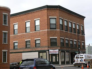
The Collins Building is an historic commercial building at 213-217 Washington Street in Dorchester, Boston, Massachusetts. The three story brick building was constructed by Charles F. Collins in 1898, and originally housed retail space on the ground floor, offices on the second, and an open function space on the third. The building is one of the few older commercial properties in the Mt. Bowdoin area, and was long associated with its Jewish community.

The Dillaway School is an historic school at 16-20 Kenilworth Street in Boston, Massachusetts. The school was built in 1882 to a design by George Albert Clough, the city's first official architect, and is his only surviving school design in the city. The building was listed on the National Register of Historic Places in 1980, and included in the Roxbury Highlands Historic District in 1989. The building has been converted to residential use.

The Harvard Avenue Historic District is a historic district roughly bounded by Linden Street, Commonwealth Avenue, Harvard Avenue, and Park Vale Avenue in the Allston neighborhood of Boston, Massachusetts. Its spine is Harvard Avenue, a major north–south thoroughfare connecting Allston to points north, and south toward Brookline. The area underwent a population explosion in the early 20th century, and Harvard Avenue was developed roughly between 1905 and 1925 as a commercial and residential spine. Notable buildings in the district include the Allston Station building, designed by Shepley, Rutan and Coolidge, and the Harvard Avenue Fire Station.
Monument Square Historic District is a predominantly residential historic district north of Monument Square in Jamaica Plain, a neighborhood of Boston, Massachusetts. The 43 acres (17 ha) district is bounded on the northwest by Pond Street, the northeast by Myrtle and Pond Streets, the southeast by Centre Street, and Holbrook and Eliot Streets to the west. This area, originally developed as country estates, was developed as a residential area in the late 19th and early 20th centuries, with its architecture reflecting a diversity of styles. Prominent non-residential buildings including the First Church of Jamaica Plain, Eliot Hall, and the Eliot School. Also included in the district is Jamaica Plain's Gothic Soldier's Monument, at the junction of South and Centre Streets.

Morton Street is a street in southern Boston, Massachusetts, United States. It extends from the southeastern end of the Arborway in Jamaica Plain to Washington Street in the Lower Mills Village of Dorchester. Most of the road is a connecting parkway, signed as part of Massachusetts Route 203, that provides access to Boston's Emerald Necklace of parks. That portion of the road was listed on the National Register of Historic Places in 2005.

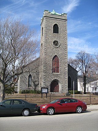
The St. Charles Borromeo Church is a historic Catholic church building in Waltham, Massachusetts. Built in 1922, it is a high quality example of Italian Renaissance Revival architecture, and is emblematic of the shift on Waltham's south side from a predominantly Protestant population to one of greater diversity. The building was listed on the National Register of Historic Places in 1989.

The Elias Boardman House is a historic house at 34 Salem Street in Wakefield, Massachusetts. Built in 1790, it is one of the city's most elaborate examples of Federal period architecture. It was built by Elias Boardman, and was dubbed Boardman's Folly for its extravagance. It was listed on the National Register of Historic Places in 1989.

The Oxford Main Street Historic District is a national historic district encompassing the historic center of Oxford, Massachusetts. The 95-acre (38 ha) district extends along Main Street from Huguenot Street in the south to Front Street in the north. Its oldest buildings are residential houses built in the late 19th century, while most of the properties were built in the 19th century, with Greek Revival architecture predominating. The oldest commercial building, the John Wetherell Store, was built c. 1817, and now houses offices. The district includes four churches, including the 1793 Universalist church and 1829 First Congregational Church, and a number of municipal buildings, including the town hall, two schools, and the 1903 Classical Revival Charles Larned Memorial Library.

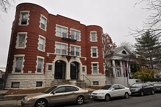
The Sarah Davidson Apartment Block is a historic commercial and multifamily residential building at 3 Gaylord Street in the Dorchester neighborhood of Boston, Massachusetts. The three story brick, sandstone and copper Classical Revival building was constructed in 1901 to a design by A. B. Pinkham. The building, located at the corner of Gaylord and Washington Streets, has three commercial storefronts facing Washington Street, which are separated by sandstone piers. The residential entrance lies on Gaylord Street recessed in a rounded sandstone archway. The exterior of the upper floors consists of protruding sections finished in pressed copper, including a rounded corner section, and sections of brick. A heavy denticulated copper cornice overhangs both street-facing facades.
The Sherman Apartments Historic District encompasses four historic residential buildings on Washington and Lyndhurst Streets in the Dorchester neighborhood of Boston, Massachusetts. The district consists of three brick six-unit buildings constructed between 1904 and 1906 by Walter U. Sherman. They were built on the site of an 1831 Greek Revival school building, which was moved by Sherman to 18 Lyndhurst Street and converted into a residential duplex. The three brick buildings are three story Classical Revival structures with modest external decoration.

Fort Hill is a 0.4 square mile neighborhood and historic district of Roxbury, in Boston, Massachusetts. The approximate boundaries of Fort Hill are Malcolm X Boulevard on the north, Washington Street on the southeast, and Columbus Avenue on the southwest.

The Governor Shirley Square Historic District encompasses a cluster of civic, residential, and religious buildings at the junction of Dudley, Hampden, and Dunmore Streets in the Roxbury neighborhood of Boston, Massachusetts. Named for colonial governor William Shirley in 1913, the square was developed in the 1870s and 1880s as a major locus of civic development after the city of Roxbury was annexed to Boston in 1868. The district was listed on the National Register of Historic Places in 2016.

The Columbia Road–Bellevue Street Historic District encompasses a collection of brick residential apartment houses on Columbia Road and Bellevue Street in the Dorchester neighborhood of Boston, Massachusetts. Arrayed mainly on Columbia Road between Wheelock Avenue and Bodwell Street, south of the Uphams Corner commercial area, area collection of primarily late 19th and early 20th-century multiunit residential buildings, built when the area was developed as a streetcar suburb. Most of these are Colonial Revival masonry or frame buildings three and four stories in height, although some exhibit Queen Anne features. There are a few older Greek Revival buildings in the district, and a number of apartment blocks built in the 1920s during a second phase of development.
The Columbia Road–Strathcona Road Historic District encompasses a collection of brick residential apartment houses on Columbia and Strathcona Roads in the Roxbury neighborhood of Boston, Massachusetts. Arrayed on the southeast side of Columbia Road between Washington and Brinsley Streets are several multistory buildings with well-preserved Colonial Revival features. They were constructed in the first two decades of the 20th century, when the area was developed as a streetcar suburb. These were built mainly by Jewish developers Saul E. Moffie and Samuel Levy to serve a growing Jewish population in the area.
The Ascension-Caproni Historic District encompasses a mixed collection of late 19th and early 20th century architecture along Washington, Newcomb, and Thorndike Streets in the Roxbury neighborhood of Boston, Massachusetts. Including religious, residential, commercial, and industrial buildings, it encapsulates the area's transition from industrial to residential uses between about 1850 and 1930. The district was listed on the National Register of Historic Places in 2019.

The Intervale Street-Blue Hill Avenue Historic District is a historic district encompassing a densely built residential area in the Dorchester neighborhood of Boston, Massachusetts. Centered on a stretch of Intervale Street near Blue Hill Avenue, the area was developed in the late 19th and early 20th centuries during a major Jewish migration, and includes a fine sample of Colonial Revival architecture. The district was listed on the National Register of Historic Places in 2020.


