Warba, Minnesota

Last updated

Warba
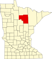
Itasca County Minnesota Incorporated and Unincorporated areas Warba Highlighted.svg
Location of the city of Warba
within Itasca County, Minnesota
Coordinates: 47°7′50″N93°16′8″W / 47.13056°N 93.26889°W / 47.13056; -93.26889
Country United States
State Minnesota
County Itasca
Area
[1]
  Total3.28 sq mi (8.49 km2)
  Land3.23 sq mi (8.35 km2)
  Water0.05 sq mi (0.13 km2)
Elevation
1,283 ft (391 m)
Population
 (2020)
  Total168
  Density52.08/sq mi (20.11/km2)
Time zone UTC-6 (Central (CST))
  Summer (DST) UTC-5 (CDT)
ZIP code
55793
Area code 218
FIPS code 27-68080 [2]
GNIS feature ID0658896 [3]

Warba is a city in Itasca County, Minnesota, United States. The population was 168 at the 2020 census.

Contents

U.S. Highway 2 serves as a main route in the community.

History

A store on U.S. Highway 2, Bridge Street, in Warba Downtown Warba, Minnesota (39986876115).jpg
A store on U.S. Highway 2, Bridge Street, in Warba

A post office called Warba has been in operation since 1910. [4] Warba is a name derived from the Ojibwe language meaning "soon". [5]

Geography

According to the United States Census Bureau, the city has a total area of 3.27 square miles (8.47 km2), of which 3.21 square miles (8.31 km2) is land and 0.06 square miles (0.16 km2) is water. [6]

Warba is along the Swan River. It is 14 miles east-southeast of Grand Rapids.

Demographics

Historical population
CensusPop.Note
1930 154
1940 124−19.5%
1950 1250.8%
1960 16229.6%
1970 148−8.6%
1980 1501.4%
1990 137−8.7%
2000 18333.6%
2010 181−1.1%
2020 168−7.2%
U.S. Decennial Census [7]

2010 census

As of the census [8] of 2010, there were 181 people, 77 households, and 47 families living in the city. The population density was 56.4 inhabitants per square mile (21.8/km2). There were 90 housing units at an average density of 28.0 per square mile (10.8/km2). The racial makeup of the city was 97.2% White and 2.8% Native American.

There were 77 households, of which 29.9% had children under the age of 18 living with them, 44.2% were married couples living together, 10.4% had a female householder with no husband present, 6.5% had a male householder with no wife present, and 39.0% were non-families. 31.2% of all households were made up of individuals, and 9.1% had someone living alone who was 65 years of age or older. The average household size was 2.35 and the average family size was 2.83.

The median age in the city was 37.8 years. 23.8% of residents were under the age of 18; 7.1% were between the ages of 18 and 24; 23.3% were from 25 to 44; 34.7% were from 45 to 64; and 11% were 65 years of age or older. The gender makeup of the city was 49.2% male and 50.8% female.

2000 census

As of the census [2] of 2000, there were 183 people, 79 households, and 57 families living in the city. The population density was 57.3 inhabitants per square mile (22.1/km2). There were 86 housing units at an average density of 26.9 per square mile (10.4/km2). The racial makeup of the city was 98.36% White, and 1.64% from two or more races. Hispanic or Latino of any race were 1.64% of the population.

There were 79 households, out of which 31.6% had children under the age of 18 living with them, 59.5% were married couples living together, 11.4% had a female householder with no husband present, and 26.6% were non-families. 22.8% of all households were made up of individuals, and 8.9% had someone living alone who was 65 years of age or older. The average household size was 2.32 and the average family size was 2.69.

In the city, the population was spread out, with 23.5% under the age of 18, 9.3% from 18 to 24, 31.7% from 25 to 44, 19.1% from 45 to 64, and 16.4% who were 65 years of age or older. The median age was 38 years. For every 100 females, there were 105.6 males. For every 100 females age 18 and over, there were 102.9 males.

The median income for a household in the city was $27,500, and the median income for a family was $31,250. Males had a median income of $21,429 versus $16,250 for females. The per capita income for the city was $11,772. About 14.3% of families and 19.6% of the population were below the poverty line, including 26.2% of those under the age of eighteen and none of those 65 or over.

See also

Related Research Articles

<span class="mw-page-title-main">Ramsey, Minnesota</span> City in Minnesota, United States

Ramsey is a suburban city 22 miles (35 km) north-northwest of downtown Minneapolis in Anoka County, Minnesota, United States. The population was 27,646 at the 2020 census. It is a northwest suburb of the Twin Cities.

Hornet Township is a township in Beltrami County, Minnesota, United States. The population was 227 as of the 2000 census.

Balsam Township is a township in Itasca County, Minnesota, United States. The population was 550 at the 2010 census.

<span class="mw-page-title-main">Bigfork, Minnesota</span> City in Minnesota, United States

Bigfork is a city in Itasca County, Minnesota, United States. The population was 446 at the 2010 census. Scenic State Park is nearby.

<span class="mw-page-title-main">Calumet, Minnesota</span> City in Minnesota, United States

Calumet is a city in Itasca County, Minnesota, United States. The population was 367 at the 2010 census.

<span class="mw-page-title-main">Coleraine, Minnesota</span> City in Minnesota, United States

Coleraine is a city in Itasca County, Minnesota, United States. The population was 1,970 at the 2010 census. The community was named after Thomas F. Cole, President of the Oliver Iron Mining Company.

Deer River Township is a township in Itasca County, Minnesota, United States. The population was 704 at the 2010 census.

<span class="mw-page-title-main">Effie, Minnesota</span> City in Minnesota, United States

Effie( EF-ee) is a city in Itasca County, Minnesota, United States. The population was 123 at the 2010 census.

<span class="mw-page-title-main">Keewatin, Minnesota</span> City in Minnesota, United States

Keewatin is a city in Itasca County, Minnesota, United States. The population was 984 at the 2020 census.

Kinghurst Township is a township in Itasca County, Minnesota, United States. The population was 106 at the 2010 census.

<span class="mw-page-title-main">La Prairie, Minnesota</span> City in Minnesota, United States

La Prairie is a city in Itasca County, Minnesota, United States. The population was 665 at the 2010 census.

Lone Pine Township is a township in Itasca County, Minnesota, United States. The population was 410 at the 2010 census.

<span class="mw-page-title-main">Marble, Minnesota</span> City in Minnesota, United States

Marble is a city in Itasca County, Minnesota, United States. It is part of the chain of small mining towns known as the Iron Range. The population was 701 at the 2010 census.

Morse Township is a township in Itasca County, Minnesota, United States. The population was 615 at the 2010 census.

Nore Township is a township in Itasca County, Minnesota, United States. The population was 57 at the 2010 census.

Oteneagen Township is a township in Itasca County, Minnesota, United States. The population was 310 at the 2010 census.

Spang Township is a township in Itasca County, Minnesota, United States. The population was 264 at the 2010 census.

<span class="mw-page-title-main">Squaw Lake, Minnesota</span> City in Minnesota, United States

Squaw Lake is a city in Itasca County, Minnesota, United States. The population was 107 at the 2010 census.

Stokes Township is a township in Itasca County, Minnesota, United States. The population was 230 at the 2010 census.

Deer Lake is an unorganized territory in Itasca County, Minnesota, United States. The population was 3,495 at the 2010 census.

References

  1. "2020 U.S. Gazetteer Files". United States Census Bureau. Retrieved July 24, 2022.
  2. 1 2 "U.S. Census website". United States Census Bureau . Retrieved January 31, 2008.
  3. "US Board on Geographic Names". United States Geological Survey. October 25, 2007. Retrieved January 31, 2008.
  4. "Itasca County". Jim Forte Postal History. Retrieved July 12, 2015.
  5. Upham, Warren (1920). Minnesota Geographic Names: Their Origin and Historic Significance. Minnesota Historical Society. p. 257.
  6. "US Gazetteer files 2010". United States Census Bureau . Retrieved November 13, 2012.
  7. "Census of Population and Housing". Census.gov. Retrieved June 4, 2015.
  8. "U.S. Census website". United States Census Bureau . Retrieved November 13, 2012.