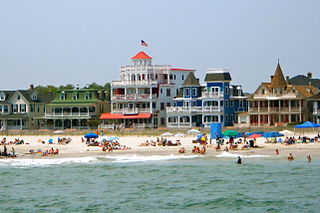
Cape May is a city located at the southern tip of Cape May Peninsula in Cape May County, New Jersey, where the Delaware Bay meets the Atlantic Ocean. One of the country's oldest vacation resort destinations, it is part of the Ocean City Metropolitan Statistical Area. As of the 2010 United States Census, the city had a year-round population of 3,607, reflecting a decline of 427 (-10.6%) from the 4,034 counted in the 2000 Census, which had in turn declined by 634 (-13.6%) from the 4,668 counted in the 1990 Census. In the summer, Cape May's population is expanded by as many as 40,000 to 50,000 visitors. The entire city of Cape May is designated the Cape May Historic District, a National Historic Landmark due to its concentration of Victorian buildings.

Ocean City is a city in Cape May County, New Jersey, United States. It is the principal city of the Ocean City Metropolitan Statistical Area, which encompasses all of Cape May County and is part of the Philadelphia-Wilmington-Camden, PA-NJ-DE-MD Combined Statistical Area. As of the 2010 United States Census, the city's population was 11,701, reflecting a decline of 3,677 (-23.9%) from the 15,378 counted in the 2000 Census, which had in turn declined by 134 (-0.9%) from the 15,512 counted in the 1990 Census. In summer months, with an influx of tourists and second homeowners, there are estimated to be 115,000 to 130,000 within the city's borders.
Route 109 is a 3.06-mile (4.92 km) state highway located in Cape May County, New Jersey, United States. The route runs from Jackson Street in Cape May north to an intersection with U.S. Route 9 in Lower Township. It crosses one of two road bridges over the Cape May Canal and provides access to the southern end of the Garden State Parkway and County Route 621 as well as to Cape May. Only the section of road in Lower Township is state maintained; the rest is maintained by Cape May County and signed as County Route 633, which extends 0.34 mi (0.55 km) past the southern terminus along Jackson Street and Perry Street to County Route 626 in West Cape May.

The Delaware Valley is the valley through which the Delaware River flows. By extension, this toponym is commonly used to refer to Greater Philadelphia or the Philadelphia metropolitan area. The region includes a metropolitan statistical area (MSA) and broader combined statistical area (CSA) that are composed of counties located in Southeastern Pennsylvania, South Jersey, Delaware, and the northern Eastern Shore of Maryland. As of the 2010 Census, the MSA has a population of over 6 million, while the CSA has a population of over 7.1 million. 2016 Census Bureau estimates rank the Delaware Valley CSA as the ninth-largest CSA in the United States.

Congress Hall is a historic hotel in Cape May, Cape May County, New Jersey, United States, occupying a city block bordered on the south by Beach Avenue and on the east by Washington Street Mall. It is a contributing building in the Cape May National Historic District.

Eltingville Transit Center is a park and ride transit center that is located in Eltingville, Staten Island. It is located at the intersection of Arthur Kill Road and Richmond Avenue, at the end of the Korean War Veterans Parkway. The transit center was completed in 2004. Amenities include schedules, maps, free parking, and vending machines for soda, snacks, and MetroCards. The center is halfway between the Eltingville Staten Island Railway station and the Staten Island Mall, another transit center, including the adjacent Yukon Depot.
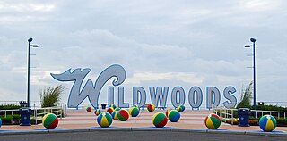
The Wildwoods are a group of five communities in Cape May County, New Jersey. These are situated on the Island of Five Mile Beach, a barrier island facing the Atlantic Ocean. These Jersey Shore communities have relatively small year-round populations that swell significantly during the summer with vacationers.

The Washington City Canal operated from 1815 until the mid-1850s in Washington, D.C. The canal connected the Anacostia River, termed the "Eastern Branch" at that time, to Tiber Creek, the Potomac River, and later the Chesapeake and Ohio Canal (C&O). The canal became disused during the late 19th century and the city government covered over or filled in various sections in 1871.
The Seacourt Pavilion is a regional shopping center on Hooper Avenue in Toms River, New Jersey. It is right across the street from the Ocean County Mall. The mall has a gross leasable area of 253,000 sq ft (23,500 m2).

Seaview Square Mall was a shopping mall located in Ocean Township, in Monmouth County, New Jersey, United States. It has been repurposed as a power center and was renamed Seaview Square Shopping Center in 2012. The 856,000-square-foot (79,500 m2) mall, located at the intersection of Route 35 and Route 66, was originally constructed in 1977 as an indoor mall. It faced stiff competition from the more upscale Monmouth Mall, located five miles (8 km) further north on Route 35 in Eatontown. One of its four anchors never opened, and several smaller stores, and Stern's and Steinbach, two of its anchors, were victims of the then-indoor mall's then-state of decline. The mall was later redeveloped into a shopping center with Target, Costco, Burlington, Home Sense, Siera Trading, Marshalls, Home Goods, Petsmart, Starbucks, and others.

The Mills at Jersey Gardens, originally and also still colloquially called Jersey Gardens, is a two-level indoor outlet mall in Elizabeth, New Jersey. The mall opened on October 21, 1999, and is the largest outlet mall in New Jersey, and much closer to New York City than its largest outlet mall competitor, Woodbury Common.

Downtown is a neighborhood of Washington, D.C., as well as a colloquial name for the central business district in the northwest quadrant of the city. It is the fourth largest central business district in the United States. Historically, the Downtown has been defined as an area east of 16th Street NW, north of the National Mall and US Capitol complex, and south of Massachusetts Avenue, including the Penn Quarter. However, the city says that most residents, workers, and visitors think of Downtown in a broader sense—including areas as far north as Dupont Circle, the Golden Triangle, as far west as Foggy Bottom, and as far east as Capitol Hill. A small portion of this area is known as the Downtown Historic District and was listed on the NRHP in 2001.

South Cape May was a borough that existed in Cape May County, New Jersey, United States, from 1894 to 1945. First settled in 1840, it contained a Lucy-type elephant named Light of Asia.
The Cape May Stage is a theatre company that performs in the Robert Shackleton Playhouse located at the corner of Bank and Lafayette Streets in downtown Cape May, New Jersey, United States.
The Grant USA Tower was a proposed 121-story skyscraper planned for Newark, New Jersey by developer Harry Grant. Harry Grant was an Iraqi-born developer who was based out of New Jersey who financed the gold dome on top of Newark City Hall The tower was to be located over the old Central Railroad of New Jersey's Newark and New York Railroad Terminal, near Broad and Lafayette Street. In 2007, the incomplete Renaissance Mall was torn down to build the Prudential Center. The old and unused part of the train station below, which was to serve as the foundation of the tower, remains in place. There are currently plans to connect the old portion of the train station with the Prudential Center, with the idea of turning it into a museum.

The borders of the oceans are the limits of Earth's oceanic waters. The definition and number of oceans can vary depending on the adopted criteria. The principal divisions of the five oceans are the Pacific Ocean, Atlantic Ocean, Indian Ocean, Southern (Antarctic) Ocean, and Arctic Ocean. Smaller regions of the oceans are called seas, gulfs, bays, straits, and other terms. Geologically, an ocean is an area of oceanic crust covered by water.
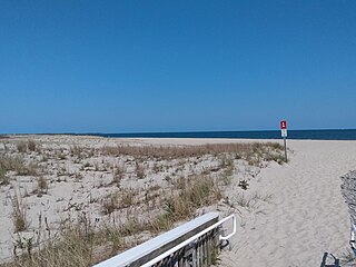
Poverty Beach or Sewell Point is a barrier spit, approximately 2.5 miles (4 km) in length entirely within the City of Cape May, along the Atlantic Ocean coast of eastern New Jersey in the United States. It is the southernmost barrier island in New Jersey.

Cape May Winery & Vineyard is a winery in Lower Township in Cape May County, New Jersey. It is outside of the North Cape May census-designated place, though sometimes its address is stated as a "North Cape May" address. Patriot-News described it as being in North Cape May.
Cape May Inlet is an inlet in southeastern Cape May County, New Jersey.

The Chalfonte Hotel is a hotel in Cape May, New Jersey. The National Park Service described it as the "Oldest and most ornate large hotel in Cape May". It is the oldest facility in the city to continually operate as a lodging facility. It is a contributing property in the Cape May Historic District, which was added to the National Register of Historic Places on December 29, 1970.

