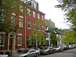
Washington Square West is a neighborhood Center City Philadelphia, Pennsylvania. The neighborhood roughly corresponds to the area between 7th and Broad Streets and between Chestnut and South Streets, bordering on the Independence Mall tourist area directly northeast, Market East to the north, Old City and Society Hill to the East, Bella Vista directly south, Hawthorne to the southwest, and mid-town Philadelphia and Rittenhouse Square to the west. In addition to being a desirable residential community, it is considered a hip, trendy neighborhood that offers a diverse array of shops, restaurants, and coffee houses. Washington Square West contains many gay-friendly establishments and hosts annual events celebrating LGBT culture in Philadelphia including OutFest. The area takes its name from Washington Square, a historic urban park in the northeastern corner of the neighborhood.

Lyon Village is a neighborhood, or "urban village" located in Arlington County, Virginia, along Lee Highway. It adjoins Arlington County's government center, and is approximately one mile west of Rosslyn and less than a mile north of Clarendon, of which it is sometimes considered a sub-neighborhood, as is Cherrydale, the mostly residential district immediately west of Lyon Village.

The Washington Park Historic District is a national historic district located in Indianapolis, Indiana. It was listed on the National Register of Historic Places on June 24, 2008. It comprises nearly 60 acres (240,000 m2) and is located 4 miles (6.4 km) north of downtown Indianapolis, in the south-central part of the Meridian-Kessler neighborhood. The district includes all properties south of 43rd Street and north of 40th Street, and west of Central Avenue and east of the alley running north and south between Pennsylvania and Meridian Streets; Washington Boulevard runs north-south through the center of the district. It includes 110 contributing buildings, ranging mostly from mansions to small bungalows, and three non-contributing buildings.

The Whitney Avenue Historic District is a historic district in the East Rock neighborhood of New Haven, Connecticut. It is a 203-acre (82 ha) district which included 1,084 contributing buildings when it was listed on the National Register of Historic Places in 1989.
Scotch Grove is an unincorporated community in Jones County, Iowa, United States. Scotch Grove is located on Iowa Highway 38, southeast of Monticello and north of Center Junction. The townsite was listed as a historic district on the National Register of Historic Places in 2014.

There are 75 properties listed on the National Register of Historic Places in Albany, New York, United States. Six are additionally designated as National Historic Landmarks (NHLs), the most of any city in the state after New York City. Another 14 are historic districts, for which 20 of the listings are also contributing properties. Two properties, both buildings, that had been listed in the past but have since been demolished have been delisted; one building that is also no longer extant remains listed.

Cathedral Historic District is a nationally recognized historic district located in Dubuque, Iowa, United States. It was listed on the National Register of Historic Places in 1985. At the time of its nomination it consisted of 124 resources, which included 96 contributing buildings, one contributing site, one contributing structure and 26 non-contributing buildings. The district was the first residential area in Dubuque, and developed into a tightly knit neighborhood. It is located west of the original commercial district and below the bluffs of the Mississippi River that rise steeply to the west. Although its original structures no longer stand, its historic buildings are largely from the mid to late 19th century. St. Raphael's Cathedral complex, from which the district receives its name, was important in serving immigrants, including most of the Irish immigrants to the city, and in building ties. In 1985, the district was deemed to have retained "most of its original character and fabric" from the late 1800s. Washington Park, J.H. Thedinga House (1855), Fenelon Place Elevator, and Redstone (1888) are all individually listed on the National Register.

Liebbe, Nourse & Rasmussen was an architectural firm in the U.S. state of Iowa. They designed Kromer Flats built in 1905. It designed courthouses, commercial buildings, and residences. Several are listed on the U.S. National Register of Historic Places.

The Mount Vernon Triangle Historic District is a historic district in the Mount Vernon Triangle neighborhood of Washington, D.C., consisting of 22 contributing residential, commercial, and industrial buildings, and one known archaeological site. The area was once a working class neighborhood for mostly German immigrants and home to semi-industrial enterprises such as a dairy and an automobile repair shop. The Northern Liberty Market that once stood on the corner of 5th Street and K Street NW played a large role in spurring development in the surrounding area as did the streetcars on Massachusetts Avenue and New York Avenue.

The Vogel Place Historic District is a nationally recognized historic district located in Ottumwa, Iowa, United States. It was listed on the National Register of Historic Places in 1995. At the time of its nomination it contained 158 resources, which included 101 contributing buildings, six contributing structures, and 51 non-contributing buildings.

Eagles Mere Historic District is a national historic district in the mountain lake resort of Eagles Mere in Shrewsbury Township, Sullivan County, Pennsylvania. The resort area was founded in the late nineteenth century and popular through the first half of the twentieth century. It surrounds Eagles Mere Lake.
Frank E. Wetherell was an American architect in the U.S. state of Iowa who was active from 1892 to 1931. He founded the second oldest architectural firm in the state in Des Moines, Iowa, in 1905. He worked with Roland Harrison in partnership Wetherell & Harrison. The firm designed numerous Masonic buildings.

The Lincoln–Fairview Historic District is a nationally recognized historic district located in Council Bluffs, Iowa, United States. It was listed on the National Register of Historic Places in 2007. At the time of its nomination the district consisted of 327 resources, including 264 contributing buildings, two contributing sites, four contributing structures, three contributing objects, 52 non-contributing buildings, and two non-contributing structures. The district is primarily a residential area north of the central business district. It includes the steep loess bluff where President Abraham Lincoln stood to survey the area when he was deciding on the eastern terminus of the Union Pacific Railroad. The Daughters of the American Revolution erected a monument at the location in 1911.

Washington Residential Historic District is a nationally recognized historic district located in Dubuque, Iowa, United States. It was listed on the National Register of Historic Places in 2015. At the time of its nomination it consisted of 327 resources, which included 262 contributing buildings, 61 non-contributing buildings, and two non-contributing objects. This is one of the early residential areas of Dubuque, and was home to its German community. It also defines the "walkable city" with commercial, industrial, and institutional buildings located here. There are a number of churches in the district from various denominations. Of particular interest are St. Mary's Catholic Church (1866), St. John's Lutheran Church (1880), and St. Matthew's Lutheran Church (1908). A significant number of the buildings were constructed in brick, and the vast majority of the buildings in the district were built by 1891. Vernacular structures are commonplace here, as are various Victorian styles. Hollenfelz House (1891) and the Dubuque Casket Company building (1894) are individually listed on the National Register. The former St. Mary's Catholic Church complex forms its own historic district within this one.

Four Mounds Estate Historic District is a nationally recognized historic district located in Dubuque, Iowa, United States. It was listed on the National Register of Historic Places in 2002. At the time of its nomination the district consisted of 19 resources, including 11 contributing buildings, two contributing sites, four non-contributing structures, and two non-contributing buildings. The estate is named for the four conical burial mounds that are located on the property. They are one of the historic sites, and they are individually listed on the National Register of Historic Places.

The Longfellow Historic District is a nationally recognized historic district located in Iowa City, Iowa, United States. It was listed on the National Register of Historic Places in 2002. At the time of its nomination, it consisted of 355 resources, which included 250 contributing buildings, 103 non-contributing buildings, and two non-contributing structures. As the University of Iowa expanded in the early 20th-century new sections were being added to the city. The Longfellow neighborhood, named after the local elementary school completed in 1919, was part of this expansion. The northern part of the neighborhood along East Court Street developed in the 19th century because the street connected the city center to the Muscatine road. The rest of the neighborhood was platted on farm land in 1908 and 1914. A trolley line was completed to the area in 1910, leading to the creation of suburban development.

The Cedar Rapids 2nd Avenue SE. Automobile Row Historic District is a nationally recognized historic district located in Cedar Rapids, Iowa, United States. It was listed on the National Register of Historic Places in 2015. At the time of its nomination it consisted of 24 resources, which included 17 contributing buildings, two contributing sites, four non-contributing buildings, and one non-contributing structure. This is a collection of commercial buildings that were built along the old Lincoln Highway between 1912 and 1953 to house automobile dealerships. They feature broad fronts with large display windows and open interiors. Auto repair shops were generally located at the rear of a dealership, but some were located in their own utilitarian buildings. Some of the corner lots were taken up by small gas stations. In later years, sales lots were placed adjacent to dealerships in order to display a larger number of cars. Other lots were occupied by used car lots. Prior to being converted into an automobile-centric commercial area, the district was a Victorian-era residential neighborhood. The multi-family dwelling at 309 8th St. SE remains as a reminder of that era, and it is one of the contributing properties.

The Greenwood Park Plats Historic District is a nationally recognized historic district located in Des Moines, Iowa, United States. It was listed on the National Register of Historic Places in 2013. At the time of its nomination the district consisted of 393 resources, including 277 contributing buildings, one contributing site, 109 non-contributing buildings, and six non-contributing structures. Most of this district was originally known as Brown's Park, a private park that was the location of the Iowa State Fair from 1879 to 1885. Founded privately in 1854, the fair was held in several locations in the state making it more of a regional event. It was also not profitable. That changed when the fair moved to this location, and its profitability eventually led to funding from the Iowa General Assembly and a permanent location on the east side of the city. Brown's Park continued for a while longer and the streetcar line from Des Moines opened in 1889.
The West Side Residential Historic District is a nationally recognized historic district located in Washington, Iowa, United States. It was listed on the National Register of Historic Places in 2018. At the time it was studied for the State of Iowa it contained 255 resources, which included 184 contributing buildings, one contributing site, one contributing structure, one contributing object, and 68 non-contributing buildings. Some of the numbers could be adjusted up for the National Register nomination as the park required further study. The historic district is a residential neighborhood on the west side of town with houses that were built from the 1850s to the 1960s. The oldest house in the district was constructed in 1856, and eight of the houses were built after 1969, the cut-off year for inclusion as a contributing property. All of the houses are single family dwellings, and most of them are frame construction. Nine of the houses are brick or stucco. They range in height from single-story to two-story structures. The district is noteworthy for its large collection of Victorian styles from the 1880s to the 1900s, but there are also a number of American Foursquare, American Craftsman, and bungalows in the neighborhood as well. The Joseph Keck House and the Frank Stewart House (1894) are individually listed on the National Register of Historic Places.

The Iowa City Downtown Historic District is a nationally recognized historic district located in Iowa City, Iowa, United States. It was listed on the National Register of Historic Places in 2021. At the time of its nomination it consisted of 102 resources, which included 73 contributing buildings, one contributing site, one contributing object, 21 non-contributing buildings, and seven non-contributing objects. Eight buildings that were previously listed on the National Register are also included in the district. Iowa City's central business district developed adjacent to the Iowa Old Capitol Building and the main campus of the University of Iowa. This juxtaposition gives the area its energy with the overlap of university staff and students and the local community. The district was significantly altered in the 1970s by the city's urban renewal effort that brought about the Ped Mall, which transformed two blocks of College Street from Clinton Street to Linn Street and Dubuque Street from Burlington Street to Washington Street. It is the contributing site and the large planters/retaining walls that are original to the project are counted together as the contributing object. There are also several freestanding, limestone planters, five contemporary sculptures, and a playground area are the non-contributing objects.


