Water pollution in New Zealand

Last updated

A sign warning of water pollution on the Waimakariri River, 2004 Water pollution sign on the Waimakariri River.JPG
A sign warning of water pollution on the Waimakariri River, 2004

Water pollution in New Zealand is an increasing concern for those who use and care for waterways and for New Zealand regulatory bodies. [1] An increase in population is linked to an increase in water pollution, due to a range of causes such as rural land use, industrial use and urban development. [2] Fresh water quality is under pressure from agriculture, hydropower, urban development, pest invasions and climate change. [3] While pollution from point sources has been reduced, diffuse pollution such as nutrients, pathogens and sediments development and from stormwater in towns is not under control. There are more than 800 water quality monitoring sites around New Zealand that are regularly sampled. [4]

Contents

As of January 2019, Auckland is the region with New Zealand's most polluted waterways, with 62% of rivers and lakes graded poor by the Ministry for the Environment for swimming, and 0% of rivers and lakes graded as good. [5]

In 2018, waterways across New Zealand have been showing improvements across a number of water quality measures, as monitored by LAWA data. [6]

Water quality guidelines

Guideline standards for water quality are published by MfE. [7]

e.coli / 100ml
< 130no calculated risk level
131–260above NCRL
261–550substantial elevation of Campylobactor infection
> 550above level of significant risk of infection

Water pollution by sector

Agriculture

Agriculture is a major use of lowland areas of New Zealand and has affected water quality. The expansion of intensive dairy production has resulted in greater levels of nitrogen in soil, surface and groundwater. [8]

In 1993, the National Institute of Water and Atmospheric Research summarised available data on the quality of water in rivers. They concluded that "Some lowland river reaches in agriculturally developed catchments are in poor condition" reflecting "agriculturally derived diffuse and point source waste inputs in isolation or in addition to urban or industrial waste inputs". The key contaminants identified in lowland rivers were dissolved inorganic nitrogen, dissolved reactive phosphorus, sediment and coliforms. Small streams in some dairy farming areas such as the Waikato and Canterbury were identified as being in relatively poor condition. [9]

Sediment from erosion of hills and river banks is also a source of pollution of waters. The sediments loading from high intensity, increasing frequency storm and high rainfall events has led to millions of tonnes of sediment changing fluvial systems in NZ waterways. This sediment contains high organic contents from forest litter which is changing sedimentation patterns and increasing organic bed loads and deposition in NZ lakes and shallow coastal waters.

Since 2005 increased dairy farming rates of grazing animals have outstripped riparian planting and the ability of some Regional councils to manage and mitigate impacts on the quality of water, and there is some evidence of urea use leading to nitrogen levels in waterways. Horticulture, arable farming and plantation forestry generally have less effect than dairy farming. [4]

In 2001 Fish and Game New Zealand started the high-profile dirty dairying campaign to highlight the effect of pollution from farming intensification on the ecological health of freshwater environments. As a reaction to this campaign Fonterra, the largest dairy company in New Zealand, along with a number of government agencies instigated the Dairying and Clean Streams Accord to address water pollution due to dairy farming. The aim of the Accord is to limit the access of stock to waterways. Fonterra exports the majority of its produce, and encourages farmers to limit environmental impacts as a method of getting environmentally aware consumers to purchase their products. The increase in research into sustainable farming and reducing fertilizer use, increasing the planting of native shrubs, grasses, flaxes and trees along the margins of streams. These techniques help intercept run off of manure, sediments and fertilizer and use them to enhance growth of the planted zones.

Over the past decade, regional councils have increasing imposed more regulatory requirements on farmers to reduce their environmental impacts. A number of councils - including Environment Canterbury, Horizons Regional Council and Hawke's Bay Regional Council require most farms to have Farm Environment Plans in place, with some farms in Otago and Waikato also required to have Farm Environment Plans in place. The plans require farmers to manage environmental risks around activities such as farm dairy effluent, erosion, discharges into waterways (through planting and fencing intensively stocked areas), irrigation and the application of nutrients. Some councils have also imposed nutrient limits on farmers.

In 2016, a controversial video by Greenpeace highlighted the contribution of dairy farming to river pollution, stating that over 60 percent of monitored rivers are unsafe to swim in. [10] This video advertisement was appealed by DairyNZ, but the Advertising Standards Authority found in favour of Greenpeace. [11]

The changes to introduce stricter environmental controls on farmers have been cited as contributing to recent trends showing waterway improvements by Horizons Regional Council and Environment Canterbury. [12] [13] They have also been cited as contributing to analysis completed by the Cawthorne Institute showing waterway quality is now improving for many water quality measures based on an analysis of LAWA sites. [14]

Domestic

Surface water drain cover in Rotorua showing advisory fish symbol Surface water drain in Rotorua.jpg
Surface water drain cover in Rotorua showing advisory fish symbol

Urban runoff is polluted with detergents, waste oil, litter and fecal matter. Some stormwater drains have a fish logo painted on the curb to highlight stormwater pollution.

Industry

Industrial processing frequently involves the discharge of process waste-water to waterways. For example, Fonterra has been discharging wastewater containing milk condensate into the Tui River, a tributary of the Mangatainoka River, and is applying for resource consents to continue doing so. [15] The Tasman Pulp and Paper Mill, now owned by Norske Skog, has been discharging waste into the Tarawera River since 1955. [16]

Recreation

High numbers of visitors to parks and other areas where there are no toilets is increasing the chance of pollution from human waste. In alpine areas, where anaerobic digestion of fecal matter is slow, the Department of Conservation have sewerage holding tanks on the toilets at backcountry huts. The sewerage is flown out by helicopter for treatment elsewhere. Freedom camping, a popular activity in some areas, is suspected of causing water pollution due to the incorrect disposal of human waste.

Urban areas

The most significant source of water pollution in urban areas is due to sewerage. Broken sewers and faulty connections allow sewerage to enter stormwater systems. [4] Also, during flooding sewerage pumping stations are inundated with the floodwaters and sewerage is released.

Water run-off from roads contains pollutants such as zinc, copper, lead and hydrocarbons from vehicle wear, vehicle emissions and from the road surface itself. [4] Urban areas have large amounts of paved surface therefore there is a higher likelihood that water contaminated with organic matter will not be filtered through soils.

Sediment run-off from exposed soils in new subdivisions does occur and if it occurs due to breaches of the resource consent prosecution may result. To limit sediment run-off during earthworks straw bales and stormwater settling ponds are used. These are completely inadequate in high rainfall events where the interceptors are overwhelmed and silt laden waters flow into streams and rivers.

Water pollution by region

Regions of New Zealand.
1 Northland
2 Auckland
3 Waikato
4 Bay of Plenty
5 East Cape
6 Hawke's Bay
7 Taranaki
8 Manawatu-Whanganui
9 Wellington
10 Tasman
11 Nelson
12 Marlborough
13 West Coast
14 Canterbury
15 Otago
16 Southland Regions of NZ Numbered.svg
Regions of New Zealand.

Regional councils have the responsibility to address water use and misuse issues as set out in the Resource Management Act, a significant Act of Parliament that regulates natural and physical resources such as land, air and water. Differing land use and climate means that water pollution varies across the regions.

Water trends for selected regions (as of 2004) [17]
RegionAllocation and abstraction[ clarification needed ]Water
quantity
Surface water qualityGroundwater
quality
Future
demand
Surface waterGround waterSurface waterGround waterMicro biologicalInorganicMicro biologicalInorganicProposed irrigation schemes
CanterburyIncreasingIncreasingUncertainUncertainUncertainUncertainUncertainDecreasingIncreasing
Hawke's BayIncreasingIncreasingSteadyDecreasingUncertainUncertainUncertainDecreasingIncreasing
WaikatoIncreasingIncreasingUncertainUncertainDecreasingDecreasingUncertainDecreasingSteady
SouthlandSteadyIncreasingSteadySteadyUncertainUncertainDecreasingUncertainUncertain

The above table is an aggregate of water trends in the regions and it shows no trends in water quality improvement or the related issue of water abstraction. However, there are observed improvements in water quality for some water bodies in some cases.

Bay of Plenty

The Tarawera River, nicknamed "the black drain", has had a history of water pollution, predominantly due to industrial activity. In 2009, the Tasman Mill gained permission to continue polluting the river for the next 25 years. [18]

Between 1950 and 1989, the Whakatane Sawmill dumped contaminated sawdust, bark, scrap timber, and chemicals in and around Whakatane and the Rangitaiki Plains, including the Kopeopeo Canal, which has been called New Zealand's most polluted waterway. [19] These wastes came from the timber treatment mill, where PCP had been used as a wood preservative. The PCP was contaminated with dioxin and furan (PCDD/PCDFs), resulting in dioxin-contaminated sediment. Remediation efforts on the canal (sparked initially by Ngāti Awa campaigner Joe Harawira) received international recognition in 2019. [20]

Canterbury

Historically much of Canterbury has been dry land and arable farming but there has been a huge increase in dairy farming in the region. Dairy farming in Canterbury requires large amounts of irrigation since the average rainfall is too low to support dairy cow pastures.

The Heathcote River has been subjected to a number of recent pollution incidents.

Environment Canterbury recently introduced strict new environmental requirements for the region's farmers, requiring most farms to develop Farm Environment Plans showing how farms will take action to mitigate risks like nutrient leaching, soil erosion, effluent risks and protect waterways through actions such as fencing off waterways and undertaking riparian planting. The plans are independently audited. Since the introduction of these new rules, waterways are now showing improvement s across a number of measures.

Southland

In Southland effluent from dairy sheds used for more than 50 cows needs a resource consent. Environment Southland recommends effluent is spread at a rate of eight hectares per 100 cows and should not applied to wet soils. [21] In 2012, Otago Regional Council carried out 19 prosecutions for incidents of pollution, twice as many as in 2011. The majority of the pollution incidents were of dairy effluent. [22]

Taranaki

In Taranaki, there are 1400 dairy sheds where the dairy effluent drains into streams instead of being sprayed to land, according to data from Taranaki Regional Council's 2012 State of the Environment report. [23] In 2012, the president of the New Zealand Freshwater Sciences Society expressed surprise at the number of consented dairy discharges to streams, given most other regional councils prosecute dairy farmers who allow dairy effluent to enter waterways. [24] In 2019, Taranaki Regional Council reported that freshwater quality had deteriorated, with only two of the fifteen sites tested meeting the standards for swimmability. [25]

Waikato

The Waikato has had a long history of dairy farming and has some of the most productive soils in the country. Water quality, especially as shown by the indicators of conductivity and pH, in the Waikato region is deteriorating. [26]

The Waikato River has a high level of pollution due to various point and non-point sources.

West Coast

The West Coast receives a high rainfall so any potential pollution will be diluted to some degree.

Until recently untreated sewerage was being discharged into the Grey River but government funding was made available to build a sewerage treatment plant.

See also

Related Research Articles

Stormwater Water that originates during precipitation events and snow/ice melt

Stormwater, also spelled storm water, is water that originates from precipitation (storm), including heavy rain and meltwater from hail and snow. Stormwater can soak into the soil (infiltrate) and become groundwater, be stored on depressed land surface in ponds and puddles, evaporate back into the atmosphere, or contribute to surface runoff. Most runoff is conveyed directly as surface water to nearby streams, rivers or other large water bodies without treatment.

Water pollution Contamination of water bodies

Water pollution is the contamination of water bodies, usually as a result of human activities, so that it negatively affects its uses. Water bodies include lakes, rivers, oceans, aquifers, reservoirs and groundwater. Water pollution results when contaminants are introduced into these water bodies. Water pollution can be attributed to one of four sources: sewage discharges, industrial activities, agricultural activities, and urban runoff including stormwater. It can be grouped into surface water pollution or groundwater pollution. For example, releasing inadequately treated wastewater into natural waters can lead to degradation of these aquatic ecosystems. Water pollution can also lead to water-borne diseases for people using polluted water for drinking, bathing, washing or irrigation. Water pollution reduces the ability of the body of water to provide the ecosystem services that it would otherwise provide.

Concentrated animal feeding operation American type of intensive animal farming at large scale

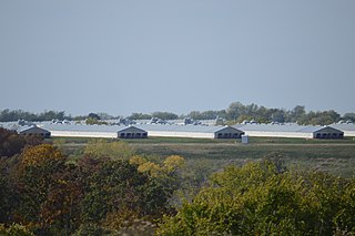
In animal husbandry, a concentrated animal feeding operation (CAFO), as defined by the United States Department of Agriculture (USDA), is an intensive animal feeding operation (AFO) in which over 1,000 animal units are confined for over 45 days a year. An animal unit is the equivalent of 1,000 pounds of "live" animal weight. A thousand animal units equates to 700 dairy cows, 1,000 meat cows, 2,500 pigs weighing more than 55 pounds (25 kg), 10,000 pigs weighing under 55 pounds, 10,000 sheep, 55,000 turkeys, 125,000 chickens, or 82,000 egg laying hens or pullets.

Cooks River River in Sydney, New South Wales, Australia

The Cooks River, a semi-mature tide dominated drowned valley estuary, is a tributary of Botany Bay, located in south-eastern Sydney, New South Wales, Australia.

Nonpoint source pollution Pollution resulting from multiple sources

Nonpoint source (NPS) pollution refers to diffuse contamination of water or air that does not originate from a single discrete source. This type of pollution is often the cumulative effect of small amounts of contaminants gathered from a large area. It is in contrast to point source pollution which results from a single source. Nonpoint source pollution generally results from land runoff, precipitation, atmospheric deposition, drainage, seepage, or hydrological modification where tracing pollution back to a single source is difficult. Nonpoint source water pollution affects a water body from sources such as polluted runoff from agricultural areas draining into a river, or wind-borne debris blowing out to sea. Nonpoint source air pollution affects air quality, from sources such as smokestacks or car tailpipes. Although these pollutants have originated from a point source, the long-range transport ability and multiple sources of the pollutant make it a nonpoint source of pollution; if the discharges were to occur to a body of water or into the atmosphere at a single location, the pollution would be single-point.

Rivers of New Zealand Overview of rivers in New Zealand

The rivers of New Zealand are used for a variety of purposes and face a number of environmental issues. In the North Island's hill country the rivers are deep, fast flowing and most are unnavigable. Many of the rivers in the South Island are braided rivers. The navigable rivers were used for mass transport in the early history of New Zealand.

The Dairying and Clean Streams Accord is an agreement signed in 2003 in New Zealand between Fonterra, Ministry for the Environment, Ministry of Agriculture and Forestry and regional councils. The Accord was prompted by the high-profile "dirty dairying" campaign by Fish and Game New Zealand which highlighted water pollution of lakes, rivers and streams due to the intensification of dairy farming in parts of New Zealand.

Urban runoff Surface runoff of rainwater created by urbanization

Urban runoff is surface runoff of rainwater, landscape irrigation, and car washing created by urbanization. Impervious surfaces are constructed during land development. During rain, storms and other precipitation events, these surfaces, along with rooftops, carry polluted stormwater to storm drains, instead of allowing the water to percolate through soil. This causes lowering of the water table and flooding since the amount of water that remains on the surface is greater. Most municipal storm sewer systems discharge stormwater, untreated, to streams, rivers and bays. This excess water can also make its way into people's properties through basement backups and seepage through building wall and floors.

In New Zealand "dirty dairying" refers to damage to the ecological health of New Zealand's freshwater environment by the intensification of dairy farming, and also to the high profile campaign begun in 2002 by the Fish and Game Council to highlight and combat this.

Agriculture in New Zealand Overview of agriculture in New Zealand

In New Zealand, agriculture is the largest sector of the tradable economy. The country exported NZ$46.4 billion worth of agricultural products in the 12 months to June 2019, 79.6% of the country's total exported goods. The agriculture, forestry and fisheries sector directly contributed $12.653 billion of the national GDP in the 12 months to September 2020, and employed 143,000 people, 5.9% of New Zealand's workforce, as of the 2018 census.

Dairy farming in New Zealand Overview article

Dairy farming in New Zealand began from small beginnings during the early days of colonisation by Europeans. The New Zealand dairy industry is based almost exclusively on cattle, with a population of 4.92 million milking cows in the 2019-20 season. The income from dairy farming is now a major part of the New Zealand economy, becoming an NZ$13.4 billion industry by 2017.

CraFarms is a group of companies of which Allan, Beth and Frank Crafar were Directors. Crafar Farms was New Zealand's largest family-owned dairy business. The family business owned 22 dry stock and dairy farms with approximately 20,000 cows in various regions of the North Island, and was put into receivership in October 2009. Crafar Farms was involved in multiple prosecutions for pollution offences and incidents of poor animal welfare from 2007 to 2011.

Water pollution in Canterbury, New Zealand Overview of the water pollution in Canterbury, New Zealand

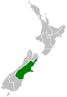
Water pollution in Canterbury, New Zealand has become a major environmental issue, largely due to pollution from agricultural sources, but also industrial and urban sources.

Water pollution in the West Coast, New Zealand Overview of the water pollution in the West Coast, New Zealand

Water pollution is an environmental issue on the West Coast of New Zealand. Water resources and water pollution come under the jurisdiction of the Resource Management Act and is controlled by the regional councils - for the West Coast it is the West Coast Regional Council.

Water pollution in the United States Overview of water pollution in the United States of America

Water pollution in the United States is a growing problem that became critical in the 19th century with the development of mechanized agriculture, mining, and industry, although laws and regulations introduced in the late 20th century have improved water quality in many water bodies. Extensive industrialization and rapid urban growth exacerbated water pollution as a lack of regulation allowed for discharges of sewage, toxic chemicals, nutrients and other pollutants into surface water.

Water in New Zealand Water supply and distribution in New Zealand

Water is relatively abundant in New Zealand due to the temperate climate and maritime weather patterns. In recent years, water pollution and draw-down of aquifers have become important environmental issues in New Zealand.

United States regulation of point source water pollution Overview of the regulation of point source water pollution in the United States of America

Point source water pollution comes from discrete conveyances and alters the chemical, biological, and physical characteristics of water. In the United States, it is largely regulated by the Clean Water Act (CWA). Among other things, the Act requires dischargers to obtain a National Pollutant Discharge Elimination System (NPDES) permit to legally discharge pollutants into a water body. However, point source pollution remains an issue in some water bodies, due to some limitations of the Act. Consequently, other regulatory approaches have emerged, such as water quality trading and voluntary community-level efforts.

Whangamarino Wetland Wetland of international importance under the Ramsar Convention

The Whangamarino Wetland in the Waikato District is the second largest wetland complex of the North Island of New Zealand. Encompassing a total area of more than 7200 hectares, the Department of Conservation Te Papa Atawhai manages 5,923 hectares of peat bog, swamp, mesotrophic lags, open water and river systems listed as a wetland of international importance under the Ramsar Convention. Fish and Game New Zealand are the second largest landowner, managing 748 hectares of the wetland primarily as gamebird hunting habitat.

Savick Brook is a watercourse in Lancashire, England, which runs from the outskirts of Longridge westward north of Preston to the River Ribble.

Water quality in Taranaki is a notable environmental issue for many stakeholders with concerns about the potential impact from dairy farming in New Zealand and petrochemical industries.

References

  1. Piddock, Gerald (2 January 2019). "Water pollution the number one concern for New Zealanders in new poll". Stuff.
  2. Our Freshwater 2020. Ministry for the Environment and Stats NZ. 16 April 2020.
  3. Gluckman, Sir Peter (12 April 2017). "New Zealand's Fresh Waters" (PDF). Prime Minister’s Chief Science Advisor.
  4. 1 2 3 4 Environment Aotearoa 2015. Ministry for the Environment. October 2015. ISBN   978-0-478-41298-7.
  5. "Rivers and lakes in Auckland Region". Ministry for the Environment. Retrieved 16 January 2019.
  6. Taunton, Esther (29 April 2018). "Freshwater quality improving nationwide, report shows". Stuff.
  7. Microbiological water quality guidelines for marine and freshwater recreational areas, MfE, June 2003, pp. H26
  8. "Environmental pressures rising in New Zealand". OECD. 21 March 2017.
  9. Smith, CM; Wilcock, RL; Vant, WN; Smith, DG; Cooper, AB (April 1993). "Freshwater quality in New Zealand and the influence of forestry, population driven land subdivision horticulture and large scale pastoral land uses such as agriculture". Consultancy Report No. MAF056. National Institute of Water and Atmospheric Research.
  10. Save Our Rivers (video). Greenpeace NZ. 2016. Archived from the original on 20 December 2021.
  11. "Greenpeace wins advert battle". The New Zealand Herald . 8 January 2017.
  12. "Improved water quality in Horizons Region shows more rivers more suitable for swimming". Horizons Regional Council. 15 February 2018.
  13. "Monitoring shows Canterbury's fresh water quality improving". Environment Canterbury. 14 November 2017.
  14. "New Zealand river water quality trends show cause for optimism". LAWA. 16 April 2018.
  15. Ray, Adam (18 May 2012). "Discharge hearing over Tui river". 3 News. Retrieved 4 November 2012.
  16. "Iwi not giving up fight against Tasman mill discharges". Radio New Zealand. 18 December 2010. Retrieved 18 December 2010.
  17. PCE (October 2004). Growing for good: Intensive farming, sustainability and New Zealand's environment. Wellington: Parliamentary Commissioner for the Environment. ISBN   1-877274-51-8 . Retrieved 18 September 2008.
  18. "Mill gets 25-year pollution consent". The New Zealand Herald. 16 October 2009. Retrieved 6 September 2013.
  19. "case study for dioxin". croesus-projects-ltd.
  20. "International award for local clean-up project | Scoop News". www.scoop.co.nz.
  21. "Farm Dairy Effluent" (PDF). Environment Southland. Archived from the original on 14 October 2008. Retrieved 13 September 2008.
  22. Fox, Rebecca (31 August 2012). "Number of farmers prosecuted more than doubles in 12 months". Otago Daily Times . Retrieved 31 August 2012. In the past year, more than twice as many Otago farmers have been prosecuted for offences - mainly relating to dairy effluent and pugging - than the year before.
  23. Stewart, Rachel (10 December 2012). "Woe betide those who question our water quality". Taranaki Daily News. Retrieved 11 December 2012. Taranaki has 1400 cow sheds discharging effluent into streams.
  24. Harvey, Helen (11 December 2012). "Taranaki Farmers' Effluent Policy Surprises Scientist". Taranaki Daily News. Retrieved 11 December 2012. The New Zealand Freshwater Sciences Society president Waikato University Professor David Hamilton said many other regional councils prosecute anyone who discharges into waterways.
  25. Martin, Robin (11 June 2019). "Taranaki freshwater flunks latest report card". RNZ.
  26. The condition of rural water and soil in the Waikato region: risks and opportunities (PDF). 1825-0708. Environment Waikato. 2008. ISBN   978-0-9582940-0-3 . Retrieved 11 September 2008.

Further reading