Waterford, Western Australia

Last updated

Waterford
Perth,  Western Australia
Clontarf Aboriginal College in Waterford, WA.jpg
The Clontarf Aboriginal College in Waterford
Waterford, Western Australia
Coordinates 32°00′57″S115°53′12″E / 32.01572°S 115.8865778°E / -32.01572; 115.8865778 (Waterford)
Population2,460 (SAL 2021) [1]
Established1980s
Postcode(s) 6152
LGA(s) City of South Perth
State electorate(s) South Perth
Federal division(s) Swan
Suburbs around Waterford:
Karawara Karawara Bentley
Manning Waterford Wilson
Salter Point Canning River Wilson

Waterford is a small riverside suburb of Perth, the state capital of Western Australia. Its local government area is the City of South Perth.

Contents

Waterford is situated on the Canning River.

History

Originally part of the suburb of Karawara, the area south of Manning Road was renamed Waterford in the 1980s.

The area is named after the birthplace in Ireland of Edmund Rice, the founder of the Christian Brothers. From 1901, the Christian Brothers were allocated land for the Clontarf Orphanage, a school and farm for orphaned and disadvantaged boys, situated on 2 square kilometres of land south of Manning Road and along the shores of the Canning River. The college is now known as the "Clontarf Aboriginal College" and is governed by a representative Board of Management which is responsible to the Catholic Archbishop of Perth through the Director of Catholic Education of Western Australia. The day-to-day running of Clontarf Aboriginal College, including the hiring of all staff and the enrolment of students, is the responsibility of the College Principal.

From 1981, portions of the land were progressively sold by Trinity College, an independent boys school in Perth which owned the land, and subdivided for housing. Streets within Waterford reflect the Irish theme, and are named after places in Ireland. Trinity College holds a remaining portion of the land which has been developed into the school's playing fields for training and PSA sport fixtures.

The 1984 five-bedroom, two-bathroom Perth Telethon Home was built by Statesman Homes in Waterford, on Cashel Way. It was auctioned live on TVW-7 and sold for A$120,000. This was a new record, as the previous Telethon Home in 1983 sold for A$97,500. [2]

Education

Waterford is near Curtin University on Manning Road. Many foreign students rent or own homes in Waterford because of its vicinity to the university and to the Waterford Plaza Shopping Centre.

Transport

Bus

Related Research Articles

Dianella is a suburb of Perth, Western Australia. It is within the local government area of the City of Stirling.

<span class="mw-page-title-main">Curtin University bus station</span> Bus station in Perth, Australia

Curtin University bus station is a Transperth bus station located at Curtin University's Bentley campus. It has eight stands and is served by 11 Transperth routes operated by Path Transit, Swan Transit and Transdev WA.

<span class="mw-page-title-main">Kensington, Western Australia</span> Suburb of Perth, Western Australia

Kensington is a residential suburb 3 km from Perth's central business district. Kensington is located within the City of South Perth and Town of Victoria Park local government areas.

<span class="mw-page-title-main">Riverton, Western Australia</span> Suburb of Perth, Western Australia

Riverton is a southeastern suburb of Perth, the capital city of Western Australia. Its local government area is the City of Canning.

<span class="mw-page-title-main">Shenton Park railway station</span> Railway station in Perth, Western Australia

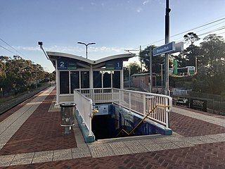
Shenton Park railway station is a commuter railway station in Shenton Park, a suburb of Perth, Western Australia. The station is on the Fremantle and Airport lines, which are part of the Transperth public transport network. It has an island platform, accessed by a pedestrian underpass. The station is only partially accessible due to a steep ramp. Services on each line run every 12 minutes during peak hour and every 15 minutes outside peak hour and on weekends and public holidays. At night, trains are every half-hour or hour. The journey to Perth railway station is 6.0 kilometres (3.7 mi), and takes 9 minutes.

<span class="mw-page-title-main">North Fremantle railway station</span> Railway station in Perth, Western Australia

North Fremantle railway station is a railway station on the Transperth network. It is located on the Fremantle line, 16.2 kilometres from Perth, serving the Fremantle suburb of North Fremantle.

<span class="mw-page-title-main">Victoria Street railway station, Perth</span> Railway station in Perth, Western Australia

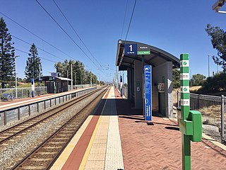
Victoria Street railway station is a railway station on the Transperth network. It is located on the Fremantle line, 14.2 kilometres from Perth station serving the suburbs of Mosman Park and Cottesloe.

<span class="mw-page-title-main">Mosman Park railway station</span> Railway station in Perth, Western Australia

Mosman Park railway station is a railway station on the Transperth network. It is located on the Fremantle line, 13.5 kilometres from Perth station serving the suburbs of Mosman Park and Cottesloe.

<span class="mw-page-title-main">Claremont railway station, Perth</span> Railway station in Perth, Western Australia

Claremont railway station is a railway station on the Transperth network in Western Australia. It is located on the Fremantle and Airport lines, 9.3 kilometres from Perth station serving the suburb of Claremont.

Wembley is a western suburb of Perth, Western Australia, located within the Town of Cambridge. Its postcode is 6014.

<span class="mw-page-title-main">Bentley, Western Australia</span> Suburb of Perth, Western Australia

Bentley is a southern suburb of Perth, the capital city of Western Australia, 8 kilometres (5.0 mi) southeast of Perth's central business district. Its local government areas are the City of Canning and the Town of Victoria Park. Bentley is home to the main campus of Curtin University and Technology Park.

<span class="mw-page-title-main">Cannington, Western Australia</span> Suburb of Perth, Western Australia

Cannington is a southern suburb of Perth, Western Australia. Its local government area is the City of Canning.

<span class="mw-page-title-main">Queens Park, Western Australia</span> Suburb of Perth, Western Australia

Queens Park is a suburb of Perth, Western Australia, located within the City of Canning. Its postcode is 6107.

Shelley is a suburb of Perth, Western Australia, located within the City of Canning.

St James is a suburb shared between the Town of Victoria Park and the City of Canning in the Perth metropolitan area.

<span class="mw-page-title-main">Willetton, Western Australia</span> Suburb of Perth, Western Australia

Willetton is a large southern suburb of Perth, Western Australia. Its local government area is the City of Canning.

<span class="mw-page-title-main">Wilson, Western Australia</span> Suburb of Perth, Western Australia

Wilson is a suburb of Perth, Western Australia, located within the City of Canning on the north bank of the Canning River. It is a fairly old suburb with parks and close proximity to prominent shopping centres in South Perth. It is favoured by Curtin University students, the reason being its convenient access to the university. Bus numbers 72 and 75 travel through this suburb. The suburb contains Castledare, Kent Street Weir, Canning River and Lo Quay River Cafe. Wilson is located quite closely to various park, some of those being Cetenary Park, Thomas Moore Park, and Alderley Park.

Shenton Park is a suburb of Perth, Western Australia, located within the City of Nedlands and City of Subiaco and 4 km (2.5 mi) west of the central business district. Its postcode is 6008. The suburb is named after the park that it contains, Shenton Park, which was named after George Shenton who originally owned the land that is now the suburb of Shenton Park.

<span class="mw-page-title-main">Belmont, Western Australia</span> Suburb of Perth, Western Australia

Belmont is a suburb of Perth, the capital city of Western Australia, and is located 7 kilometres (4 mi) east of Perth's central business district (CBD) on the southern bank of the Swan River. Its local government area is the City of Belmont.

<span class="mw-page-title-main">Nedlands, Western Australia</span> Suburb of Perth, Western Australia

Nedlands is a western suburb of Perth, the capital city of Western Australia. It is a part of the local government areas of the City of Nedlands and the City of Perth. It is about 7 kilometres (4 mi) from the Perth CBD via either Thomas Street or Mounts Bay Road.

References

  1. Australian Bureau of Statistics (28 June 2022). "Waterford (WA) (suburb and locality)". Australian Census 2021 QuickStats. Retrieved 28 June 2022.  OOjs UI icon edit-ltr-progressive.svg
  2. Archived at Ghostarchive and the Wayback Machine : 1984 Telethon Home Auction. YouTube .
  3. "Route 30". Bus Timetable 12 (PDF). Transperth. 25 August 2023 [effective from 20 November 2023].
  4. "Route 100". Bus Timetable 20 (PDF). Transperth. 25 August 2023 [effective from 20 November 2023].
  5. "Route 101". Bus Timetable 20 (PDF). Transperth. 25 August 2023 [effective from 20 November 2023].
  6. "Route 998". CircleRoute Timetable 200 (PDF). Transperth. 29 August 2023 [effective from 20 November 2023].
  7. "Route 999". CircleRoute Timetable 200 (PDF). Transperth. 29 August 2023 [effective from 20 November 2023].