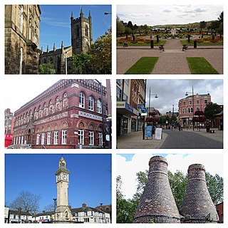
Stoke-on-Trent is a city and unitary authority area in Staffordshire, England, with an area of 36 square miles (93 km2). In 2019, the city had an estimated population of 256,375. It is the largest settlement in Staffordshire and is surrounded by the towns of Newcastle-under-Lyme, Alsager, Kidsgrove, Biddulph and Stone which form a conurbation around the city.

Biddulph is a town in Staffordshire, England, 8.5 miles (14 km) north of Stoke-on-Trent and 4.5 miles (7 km) south-east of Congleton, Cheshire.

The North Staffordshire Railway (NSR) was a British railway company formed in 1845 to promote a number of lines in the Staffordshire Potteries and surrounding areas in Staffordshire, Cheshire, Derbyshire and Shropshire.

Hanley is one of the six towns that, along with Burslem, Longton, Fenton, Tunstall and Stoke-upon-Trent, amalgamated to form the City of Stoke-on-Trent in Staffordshire, England.

The Staffordshire Potteries is the industrial area encompassing the six towns Burslem, Fenton, Hanley, Longton, Stoke and Tunstall, that now make up the city of Stoke-on-Trent in Staffordshire, England. North Staffordshire became a centre of ceramic production in the early 17th century, due to the local availability of clay, salt, lead and coal.

Burslem is one of the six towns that along with Hanley, Tunstall, Fenton, Longton and Stoke-upon-Trent form part of the city of Stoke-on-Trent in Staffordshire, England. It is often referred to as the "mother town" of Stoke on Trent.

Stoke-on-Trent railway station is a mainline railway station serving the city of Stoke-on-Trent. It lies on the Stafford to Manchester branch of the West Coast Main Line. The station also provides an interchange between various local services running through Cheshire, Staffordshire and Derbyshire.

Barlaston is a village and civil parish in the borough of Stafford in the county of Staffordshire, England. It is roughly halfway between the city of Stoke-on-Trent and the small town of Stone. According to the 2001 census the population of the parish was 2,659, rising at the 2011 Census to 2,858.

Uttoxeter railway stationpronounced (listen) (help·info) in Uttoxeter, Staffordshire, England, is served by trains on the Crewe-Derby Line, which is also a Community rail line known as the North Staffordshire line. The station is owned by Network Rail and managed by East Midlands Railway. The full range of tickets for travel are purchased from the guard on the train at no extra cost since there are no retail facilities at this station. It is the closest railway station to Alton Towers to which it is linked by a semi-regular bus service. A taxi rank also exists just next to the station.
Shelton is an area of the city of Stoke-on-Trent in Staffordshire, England, between Hanley and Stoke-upon-Trent.
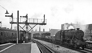
The Potteries Loop Line was a railway line that ran through the heart of Stoke-on-Trent, Staffordshire, England. It was built by the North Staffordshire Railway off its main line.

Hanley railway station was built by the North Staffordshire Railway as part of the Potteries Loop Line and served the town of Hanley, Staffordshire, England.

Tunstall railway station was located on the Potteries Loop Line and served the town of Tunstall, Staffordshire. The station closed down along with the Potteries Loop Line in 1964.
The Churnet Valley line was one of the three original routes planned and built by the North Staffordshire Railway. Authorised in 1846, the line opened in 1849 and ran from North Rode in Cheshire to Uttoxeter in East Staffordshire. The line was closed in several stages between 1964 and 1988 but part of the central section passed into the hands of a preservation society and today operates as the Churnet Valley Railway.

Burslem railway station was a station on the Potteries Loop Line that served the town of Burslem, Staffordshire. It was located on Moorland Road, adjacent to Burslem Park. It should have opened with the extension of the Potteries Loop Line from Hanley on 1 November 1873 but the Board of Trade inspector was not satisfied so there was a delay of a month before opening.

Cobridge railway station was located on the Potteries Loop Line and served the Cobridge area of Stoke-on-Trent, Staffordshire, England. The station was located between Elder Road and Sandbach Road.
Pitts Hill railway station served the Pitts Hill area of Stoke-on-Trent, Staffordshire, England.

The Stoke Streetcar was a proposed bus rapid transit system for The Potteries Urban Area in England. It would have consisted of two lines, serving five of Stoke's six towns, the city centre with its new Central Business District, Newcastle, Kidsgrove, Stoke-on-Trent railway station, the University Hospital of North Staffordshire, both universities and both football clubs. The proposal was developed in partnership with First Group, and included plans to use the same Wright StreetCar as the FTR services found in York, Leeds and Swansea.

Cobridge is an area of Stoke-on-Trent, in the City of Stoke-on-Trent district, in the county of Staffordshire, England. Cobridge was marked on the 1775 Yates map as 'Cow Bridge' and was recorded in Ward records (1843) as Cobridge Gate.
The Biddulph Valley line was a double tracked line that ran from Stoke-on-Trent to Brunswick Wharf in Congleton. The line was named after the town of the same name as it ran via the Staffordshire Moorlands and covered areas of East Staffordshire and Cheshire.
