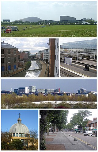
Milton Keynes is a city and the largest settlement in Buckinghamshire, England, about 50 miles (80 km) north-west of London. At the 2021 Census, the population of its urban area was over 256,000. The River Great Ouse forms its northern boundary; a tributary, the River Ouzel, meanders through its linear parks and balancing lakes. Approximately 25% of the urban area is parkland or woodland and includes two Sites of Special Scientific Interest (SSSIs).

Bletchley is a constituent town of Milton Keynes, Buckinghamshire, England. It is situated in the south-west of Milton Keynes, and is split between the civil parishes of Bletchley and Fenny Stratford and West Bletchley.

Shenley Church End is a village, district and wider civil parish in Milton Keynes England. Together with its neighbouring districts of Shenley Brook End, Shenley Wood and Shenley Lodge, the districts are collectively known as "The Shenleys".

Walton (historically) was a hamlet that is now a district and civil parish in Milton Keynes, Buckinghamshire, England. For local government purposes, it is part of the Danesborough and Walton electoral ward.
Denbigh is a district in Milton Keynes, Buckinghamshire, England, to the north of Fenny Stratford and on the eastern side of the West Coast Main Line. It is in the civil parish of Bletchley and Fenny Stratford and is categorised by the Office of National Statistics as part of the Bletchley built-up area. The A5 forms its eastern and northern boundary; parts of Bletcham Way and Saxon St form its southern boundary. The overall district has five sub districts, divided by Watling St/Denbigh Rd, the 'uptick' of Bletcham Way and Grafton Street, and Saxon Street northbound. The district names are planning designations that have persisted without ever being changed to the style "North Denbigh" etc. as is the norm elsewhere in Britain.

Bletchley is a railway station that serves the southern parts of Milton Keynes, England, and the north-eastern parts of Aylesbury Vale. It is 47 miles (75 km) northwest of Euston, about 32 miles (51 km) east of Oxford and 17 miles (27 km) west of Bedford, and is one of the seven railway stations serving the Milton Keynes urban area.

Wolverton railway station serves the town of Wolverton in Milton Keynes, Buckinghamshire, England. The station is on the West Coast Main Line, about 52 miles (84 km) from Euston, between Milton Keynes Central and Northampton. The station is one of the seven stations serving the Milton Keynes urban area.

The National Bowl is an entertainment venue located in Milton Keynes, Buckinghamshire, England. The site was a former clay pit, filled in and raised to form an amphitheatre using sub-soil excavated by the many new developments in the area. It has a maximum capacity of 65,000. The arena is open-air grassland, without seats.
Bletchley and Fenny Stratford is a civil parish with a town council, in Milton Keynes, Buckinghamshire, England. It was formed in 2001 from the unparished area of Milton Keynes, and according to the 2011 census had a population of 15,313. Together with West Bletchley, it forms the Bletchley built-up area.

Stantonbury School is a coeducational secondary school located in north Milton Keynes, England, established in 1974. It is the second largest secondary comprehensive school in the United Kingdom with more than 1,600 school students aged 11–18, as of January 2020. It is built as part of a community site, including shared facilities including 'Stantonbury Sports & Leisure Centre', 'Stantonbury Theatre', a health centre and a church.

Denbigh School is a secondary academy school in Shenley Church End, Milton Keynes in south central England.

Milton Keynes University Hospital is a district general hospital serving Milton Keynes, its local authority area and the surrounding area of Buckinghamshire, Northamptonshire, Bedfordshire and Oxfordshire. It is located in the Eaglestone neighbourhood, and opened in 1984. It is managed by Milton Keynes University Hospital NHS Foundation Trust. The hospital has an association with the University of Buckingham Medical School.

This history of Milton Keynes details its development from the earliest human settlements, through the plans for a 'new city' for 250,000 people in northern Southeast England, its subsequent urban design and development, to the present day. Milton Keynes is the largest settlement and only city in Buckinghamshire, founded in 1967. At the 2021 census, the population of its urban area was estimated to have exceeded 256,000.
Walton High is a large academy school with two campuses located in the Walnut Tree and Brooklands areas of eastern Milton Keynes in Buckinghamshire, England. Walton High’s sixth form centre, Post-16, is one of the more successful in the area on some measures, attracting pupils from across Milton Keynes.
Milton Keynes City Council is the local authority for the City of Milton Keynes, a unitary authority in Buckinghamshire, England. Until 1 April 1997 it was a non-metropolitan district.

Sir Herbert Leon Academy is a coeducational comprehensive secondary academy school and sixth form located in Bletchley, Milton Keynes, England. It is currently sponsored by the Academies Enterprise Trust, having become an academy under this sponsorship. Originally founded as two separate boys and girls schools on Bletchley Road (Queensway), the schools unified as a coeducational senior school in 1937. In the 1960s it was renamed to Leon Secondary School, in honour of Sir Herbert Leon, and relocated to Fern Grove in 1971, becoming a comprehensive. The school specialised and became the Leon School and Sports College sometime between 1996 and 2001, and academized as Sir Herbert Leon Academy in 2012. Between 2011 and 2014, the school hosted one of two campuses for the Milton Keynes South Sixth Form, in collaboration with nearby Lord Grey School.

Denbigh Hall railway station was a temporary terminus station on the London and Birmingham Railway in the Denbigh area of what is now Milton Keynes in Buckinghamshire, England. It was situated about 1 mile (1.6 km) north of Bletchley railway station, near a point where the railway crossed Watling Street. It was open for less than six months, between April and September 1838.
Simpson and Ashland is a civil parish in the south of Milton Keynes in Buckinghamshire, England.
Whitehouse is a district and civil parish that covers a large new development area on the western flank of Milton Keynes, Buckinghamshire, England. As the first tier of Local Government, its community council is responsible for the people, living and working in this area of Milton Keynes.
