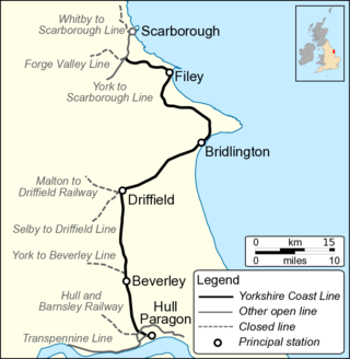
The Hull–Scarborough line, also known as the Yorkshire Coast Line, is a minor railway line in northern England used primarily for passenger traffic. It runs northwards from Hull Paragon via Beverley and Driffield to Bridlington, joining the York–Scarborough line at a junction near Seamer before terminating at Scarborough railway station.

Sleights is a railway station on the Esk Valley Line, which runs between Middlesbrough and Whitby via Nunthorpe. The station, situated 2 miles 78 chains (4.8 km) south-west of Whitby, serves the villages of Briggswath and Sleights, Scarborough in North Yorkshire, England. It is owned by Network Rail and managed by Northern Trains.

Ruswarp is a railway station on the Esk Valley Line, which runs between Middlesbrough and Whitby via Nunthorpe. The station, situated 1 mile 30 chains (2.2 km) south-west of Whitby, serves the village of Ruswarp, Scarborough in North Yorkshire, England. It is owned by Network Rail and managed by Northern Trains.

Rillington railway station was a railway station serving the village of Rillington in North Yorkshire, England and on the York to Scarborough Line. It was also the junction station for the line to Whitby and was opened on 5 July 1845 by the York and North Midland Railway. It closed to normal passenger traffic on 22 September 1930, but was used by special trains until the 1960s. The goods yard was closed on 10 August 1964. The station building has been converted to a private house but the remainder of the station has now been demolished.

The Malton and Driffield Junction Railway, later known as the Malton and Driffield branch was a railway line in Yorkshire that ran between the towns of Malton, North Yorkshire and Driffield in the East Riding of Yorkshire.

Fyling Hall railway station was a railway station on the Scarborough & Whitby Railway. It opened on 16 July 1885, and was named after Fyling Hall, near Fylingthorpe. It was a small rural station with one platform, serving a catchment of less than 200 people.

Robin Hood's Bay railway station was a railway station on the Scarborough & Whitby Railway situated 15 miles (24 km) from Scarborough and 6 miles (9.7 km) from Whitby It opened on 16 July 1885, and served the fishing village of Robin Hood's Bay, and to a lesser extent the village of Fylingthorpe. On the north-bound journey trains had to climb a mile and a half at 1-in-43 out of the station.

Whitby West Cliff railway station was a railway station on the Whitby Redcar and Middlesbrough Union Railway. It was opened on 3 December 1883, to serve the West Cliff area of the town of Whitby, North Yorkshire, England. It was one of two stations serving Whitby; the other was Whitby Town railway station, which served the lines to Malton and Battersby.

Staithes railway station was a railway station on the Whitby Redcar and Middlesbrough Union Railway, serving the villages of Staithes and Dalehouse in North Yorkshire, England. It was opened on 3 December 1883.

Sherburn is a village and civil parish in North Yorkshire, England. It is situated on the south side of the Vale of Pickering, immediately north of the Yorkshire Wolds. Sherburn lies 4 miles (6.4 km) north of Weaverthorpe, 3 miles (4.8 km) south of Brompton, 2 miles (3.2 km) east of East Heslerton and 2 miles (3.2 km) west of Ganton.

Weaverthorpe is a village and civil parish in North Yorkshire, England. It is 13 miles (21 km) south-west of Scarborough.

Helmsley railway station served the market town of Helmsley in North Yorkshire from 1871 until 1964, although the regular passenger service ceased in 1953. Helmsley station was nearly 15 miles (24 km) from Pilmoor station on the East Coast Main Line, and 12 miles (19 km) from Pickering.

The Pilmoor, Boroughbridge and Knaresborough Railway was a railway line in North Yorkshire, England, that connected Pilmoor on the East Coast Main Line with the towns of Boroughbridge and Knaresborough. The first part of the branch headed south-westwards from the East Coast Main Line and terminated at Boroughbridge. In 1875, the branch was extended again to meet the line at Knaresborough.

The Thirsk and Malton line was a railway line that ran from a triangular junction on what is now the East Coast Main Line and served eight villages between Thirsk and Malton in North Yorkshire, England. The line was built after a protracted process due to inefficiencies and financial problems suffered by the then York and North Midland Railway.

The Gilling and Pickering line (G&P) was a railway line that ran from Gilling to Pickering in North Yorkshire, England.

Goldsborough railway station served the village of Goldsborough, North Yorkshire, England from 1850 to 1965 on the Harrogate line. The station was over 13 miles (21 km) west of York railway station, and nearly 3 miles (4.8 km) east of Knaresborough.

Stokesley railway station was a railway station built to serve the town of Stokesley in North Yorkshire, England. The station was on the North Yorkshire and Cleveland line between Sexhow and Ingleby, which opened in 1857. The line was extended progressively until it met the Whitby & Pickering Railway at Grosmont. It was closed in 1954 to passengers and eleven years later to goods. The station was located 16 miles (26 km) south of Stockton and 3.5 miles (5.6 km) west of Battersby station.

Prospect Hill Junction was a railway junction in Whitby, North Yorkshire, England. The junction had access to the line into Whitby Town railway station, Whitby West Cliff railway station, and also to the Scarborough line, which went south across Larpool Viaduct. It first saw traffic in December 1883, but did not open as a junction until 1885. It was closed to passenger and freight traffic in March 1965, though the lines were not lifted until 1973.

Monk Fryston railway station was a railway station serving the village of Monk Fryston in North Yorkshire, England. Previously, Milford Junction and Old Junction served as an interchange between the Leeds and Selby and the York and North Midland Lines, however when they closed in the early 1900s, Monk Fryston was opened to cover for this loss of interchange. Though the station had four tracks through it, it only ever had two platforms. The station closed to passengers in 1959, and then completely in 1964.
Gascoigne Wood Junction railway station was a railway station near Sherburn-in-Elmet in North Yorkshire, England. It was originally opened as a junction station, enabling transfers for passengers between trains. It was later a private halt station for the staff who worked at the Gascoigne Wood marshalling yard. It opened in 1839, and was closed, renamed and re-opened several times before closing completely in 1959. The station was 14 miles (23 km) from Leeds New Station, and 6 miles (9.7 km) from Selby.

