Webber, Kansas

Last updated

Webber, Kansas
Jewell County Kansas Incorporated and Unincorporated areas Webber Highlighted.svg
Location within Jewell County and Kansas
Map of Jewell Co, Ks, USA.png
Coordinates: 39°56′04″N98°02′06″W / 39.93444°N 98.03500°W / 39.93444; -98.03500 [1]
Country United States
State Kansas
County Jewell
Founded1880s
Incorporated 1925
Named for Dan Webber
Area
[2]
  Total0.12 sq mi (0.30 km2)
  Land0.12 sq mi (0.30 km2)
  Water0.00 sq mi (0.00 km2)
Elevation
[1]
1,667 ft (508 m)
Population
 (2020) [3]
  Total30
  Density250/sq mi (100/km2)
Time zone UTC-6 (CST)
  Summer (DST) UTC-5 (CDT)
ZIP code
66970
Area code 785
FIPS code 20-76250
GNIS ID 2397240 [1]

Webber is a city in Jewell County, Kansas, United States. [1] As of the 2020 census, the population of the city was 30. [3]

Contents

History

In 1887, Atchison, Topeka and Santa Fe Railway built a branch line from Neva (3 miles west of Strong City) through Webber to Superior, Nebraska. In 1996, the Atchison, Topeka and Santa Fe Railway merged with Burlington Northern Railroad and renamed to the current BNSF Railway. Most locals still refer to this railroad as the "Santa Fe".

The first post office in Webber was established in November 1889. [4] The community was named for Dan Webber, an original landowner. [5]

Geography

According to the United States Census Bureau, the city has a total area of 0.11 square miles (0.28 km2), all of it land. [6]

Demographics

Historical population
CensusPop.Note
1930 126
1940 104−17.5%
1950 96−7.7%
1960 58−39.6%
1970 49−15.5%
1980 538.2%
1990 39−26.4%
2000 37−5.1%
2010 25−32.4%
2020 3020.0%
U.S. Decennial Census

2010 census

As of the census [7] of 2010, there were 25 people, 13 households, and 8 families living in the city. The population density was 227.3 inhabitants per square mile (87.8/km2). There were 27 housing units at an average density of 245.5 per square mile (94.8/km2). The racial makeup of the city was 100.0% White.

There were 13 households, of which 7.7% had children under the age of 18 living with them, 61.5% were married couples living together, and 38.5% were non-families. 38.5% of all households were made up of individuals, and 7.7% had someone living alone who was 65 years of age or older. The average household size was 1.92 and the average family size was 2.50.

The median age in the city was 58.8 years. 4% of residents were under the age of 18; 0.0% were between the ages of 18 and 24; 8% were from 25 to 44; 52% were from 45 to 64; and 36% were 65 years of age or older. The gender makeup of the city was 68.0% male and 32.0% female.

2000 census

As of the census [8] of 2000, there were 37 people, 20 households, and 14 families living in the city. The population density was 333.8 inhabitants per square mile (128.9/km2). There were 25 housing units at an average density of 225.6 per square mile (87.1/km2). The racial makeup of the city was 100.00% White.

There were 20 households, out of which 10.0% had children under the age of 18 living with them, 60.0% were married couples living together, 5.0% had a female householder with no husband present, and 30.0% were non-families. 30.0% of all households were made up of individuals, and 20.0% had someone living alone who was 65 years of age or older. The average household size was 1.85 and the average family size was 2.21.

June 24, 1947 flood of the Republican River on the border of Jewell County, Kansas and Republic County, Kansas near Hardy, Nebraska and Webber, Kansas, just south of Nebraska NE-8 on Kansas 1 Rd/CR-1 bridge over the Republican River. The normal flood stage for the river is at the tree line in the foreground. RepublicanRiver1947.jpg
June 24, 1947 flood of the Republican River on the border of Jewell County, Kansas and Republic County, Kansas near Hardy, Nebraska and Webber, Kansas, just south of Nebraska NE-8 on Kansas 1 Rd/CR-1 bridge over the Republican River. The normal flood stage for the river is at the tree line in the foreground.

In the city, the population was spread out, with 10.8% under the age of 18, 16.2% from 25 to 44, 24.3% from 45 to 64, and 48.6% who were 65 years of age or older. The median age was 65 years. For every 100 females, there were 131.3 males. For every 100 females age 18 and over, there were 120.0 males.

The median income for a household in the city was $25,417, and the median income for a family was $26,250. Males had a median income of $16,250 versus $23,750 for females. The per capita income for the city was $11,769. None of the population and none of the families were below the poverty line.

Education

The community is served by Rock Hills USD 107 public school district. [9] It was formed in 2006 by the consolidation of White Rock USD 104 and Mankato USD 278. [10]

See also

Related Research Articles

<span class="mw-page-title-main">Ellinwood, Kansas</span> City in Barton County, Kansas

Ellinwood is a city in the southeast corner of Barton County, Kansas, United States. As of the 2020 census, the population of the city was 2,011.

<span class="mw-page-title-main">Morrill, Kansas</span> City in Brown County, Kansas

Morrill is a city in Brown County, Kansas, United States. As of the 2020 census, the population of the city was 218.

<span class="mw-page-title-main">Longford, Kansas</span> City in Clay County, Kansas

Longford is a city in Clay County, Kansas, United States. As of the 2020 census, the population of the city was 73.

<span class="mw-page-title-main">Aurora, Kansas</span> City in Cloud County, Kansas

Aurora is a city in Cloud County, Kansas, United States. As of the 2020 census, the population of the city was 56.

<span class="mw-page-title-main">Manchester, Kansas</span> City in Dickinson County, Kansas

Manchester is a city in Dickinson County, Kansas, United States. As of the 2020 census, the population of the city was 47.

<span class="mw-page-title-main">Morland, Kansas</span> City in Graham County, Kansas

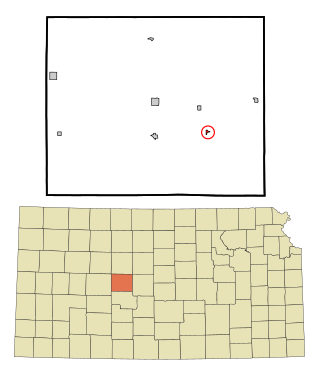
Morland is a city in Graham County, Kansas, United States. As of the 2020 census, the population of the city was 115.

<span class="mw-page-title-main">Winchester, Kansas</span> City in Kansas, United States

Winchester is a city in Jefferson County, Kansas, United States. As of the 2020 census, the population of the city was 461.

<span class="mw-page-title-main">Formoso, Kansas</span> City in Jewell County, Kansas

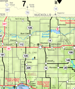
Formoso is a city in Jewell County, Kansas, United States. As of the 2020 census, the population of the city was 94.

<span class="mw-page-title-main">Randall, Kansas</span> City in Jewell County, Kansas

Randall is a city in Jewell County, Kansas, United States. As of the 2020 census, the population of the city was 79.

<span class="mw-page-title-main">Lakin, Kansas</span> City in Kearny County, Kansas

Lakin is a city in and the county seat of Kearny County, Kansas, United States. As of the 2020 census, the population of the city was 2,205.

<span class="mw-page-title-main">Bern, Kansas</span> City in Nemaha County, Kansas

Bern is a city in Nemaha County, Kansas, United States. As of the 2020 census, the population of the city was 161.

<span class="mw-page-title-main">Wetmore, Kansas</span> City in Nemaha County, Kansas

Wetmore is a city in Nemaha County, Kansas, United States. As of the 2020 census, the population of the city was 348.

<span class="mw-page-title-main">Burlingame, Kansas</span> City in Osage County, Kansas

Burlingame is a city in Osage County, Kansas, United States. As of the 2020 census, the population of the city was 971.

<span class="mw-page-title-main">Carbondale, Kansas</span> City in Osage County, Kansas

Carbondale is a city in Osage County, Kansas, United States. As of the 2020 census, the population of the city was 1,352. It is located south of Topeka along U.S. Route 75 four lane freeway.

<span class="mw-page-title-main">Munden, Kansas</span> City in Republic County, Kansas

Munden is a city in Republic County, Kansas, United States. As of the 2020 census, the population of the city was 96.

<span class="mw-page-title-main">Narka, Kansas</span> City in Republic County, Kansas

Narka is a city in Republic County, Kansas, United States. As of the 2020 census, the population of the city was 81.

<span class="mw-page-title-main">Republic, Kansas</span> City in Republic County, Kansas, United States

Republic is a city in Republic County, Kansas, United States. As of the 2020 census, the population of the city was 82.

<span class="mw-page-title-main">Timken, Kansas</span> City in Rush County, Kansas

Timken is a city in Rush County, Kansas, United States. As of the 2020 census, the population of the city was 38.

<span class="mw-page-title-main">Maple Hill, Kansas</span> City in Wabaunsee County, Kansas

Maple Hill is a city in Wabaunsee County, Kansas, United States. As of the 2020 census, the population of the city was 631.

<span class="mw-page-title-main">Washington, Kansas</span> City in Washington County, Kansas

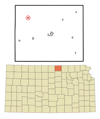
Washington is a city in, and the county seat of, Washington County, Kansas, United States. As of the 2020 census, the population of the city was 1,071.

References

  1. 1 2 3 4 U.S. Geological Survey Geographic Names Information System: Webber, Kansas
  2. "2019 U.S. Gazetteer Files". United States Census Bureau. Retrieved July 24, 2020.
  3. 1 2 "Profile of Webber, Kansas in 2020". United States Census Bureau. Archived from the original on April 1, 2022. Retrieved April 1, 2022.
  4. "Kansas Post Offices, 1828-1961, page 2 (archived)". Kansas Historical Society. Retrieved June 11, 2014.
  5. "Profile for Webber, Kansas". ePodunk . Retrieved June 12, 2014.
  6. "US Gazetteer files 2010". United States Census Bureau . Retrieved July 6, 2012.
  7. "U.S. Census website". United States Census Bureau . Retrieved July 6, 2012.
  8. "U.S. Census website". United States Census Bureau . Retrieved January 31, 2008.
  9. "USD 107 Map" (PDF). Kansas Department of Transportation . Retrieved April 29, 2020.
  10. "School consolidations in Kansas for past decade". The Topeka Capital-Journal . July 24, 2011. Retrieved April 26, 2020.

Further reading