Etobicoke is an administrative district of, and one of six municipalities amalgamated into, the city of Toronto, Ontario, Canada. Comprising the city's west-end, Etobicoke was first settled by Europeans in the 1790s, and the municipality grew into city status in the 20th century. Several independent villages and towns developed and became part of Metropolitan Toronto in 1954. In 1998, its city status and government dissolved after it was amalgamated into present-day Toronto. Etobicoke is bordered on the south by Lake Ontario, on the east by the Humber River, on the west by Etobicoke Creek, the city of Mississauga, and the Toronto Pearson International Airport, and on the north by Steeles Avenue West.

Erin is a town in Wellington County, approximately 80 kilometres (50 mi) northwest of Toronto, Ontario, Canada. Erin is bordered by the Town of Caledon, Ontario to the east, the Town of Halton Hills to the south, the Township of Guelph/Eramosa to the west and the Township of East Garafraxa to the north.

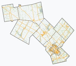
Wellington County is a county located in Southwestern Ontario, Canada and is part of the Greater Golden Horseshoe. The County, made up of two towns and five townships, is predominantly rural in nature. However many of the residents in the southern part of the County commute to urban areas such as Guelph, Kitchener, Waterloo, Brampton, Mississauga, Toronto and Hamilton for employment. The northern part of the county is made up of mainly rural farming communities, except for a few larger towns such as Mount Forest and Arthur. According to the 2016 Census, the population of the County was 222,726.

Puslinch is a township in south-central Ontario, Canada, in Wellington County, surrounding the south end of Guelph. The main source of production is agricultural, spring water bottling and mining. Aggregate mining has been dominant throughout the county. About half of the township is forested, and a conservation area lies to the southwest. Near the western edge of the township, just outside Cambridge, Ontario, is Puslinch Lake, the largest kettle lake in North America. It is part of the Guelph census metropolitan area.

East Gwillimbury is a town on the East Holland River in the upper-tier municipality the Regional Municipality of York. It is part of the Greater Toronto Area of southern Ontario, in Canada. It was formed by the amalgamation of the Township of East Gwillimbury with all the previously incorporated villages and hamlets within the township. The main centres in East Gwillimbury are the villages of Holland Landing, Queensville, Sharon, and Mount Albert. The Civic Centre are located along Leslie Street in Sharon. The northernmost interchange of Highway 404 is at the North edge of East Gwillimbury, just south of Ravenshoe Road. The hamlets of Holt and Brown Hill are also within town limits.

Essa is a township in Ontario, Canada, west and south of the city of Barrie in Simcoe County. It is bounded by County Road 90 to its north, County Road 27 to its east, and Ontario Highway 89 to its south. The township is about 100 kilometres (62 mi) from Toronto. The township is well known for its agriculture industry, particularly potato farming. Nearby CFB Borden brings a strong military presence to the area as well, including a high number of Francophone families.

Mount Forest is an unincorporated community located at the junction of Highway 6 and Highway 89 in the township of Wellington North, Ontario, Canada. As of the 2011 Canadian census the population of Mount Forest was 4,757.

Fergus is the largest community in Centre Wellington, a township within Wellington County in Ontario, Canada. It lies on the Grand River about 18 km NNW of Guelph. The population of this community at the time of the 2016 Census was 20,767, but the community is growing as new homes are being built for sale.
Dufferin County is a county and census division located in Central Ontario, Canada. The county seat is Orangeville, and the current Warden is Darren White. The current chief administrative officer is Sonya Pritchard. Dufferin covers an area of 1,486.31 square kilometres (573.87 sq mi), and its population was 61,735 at the time of the 2016 Census.

Quinte West is a city, geographically located in but administratively separated from Hastings County, in Southern Ontario, Canada. It is located on the western end of the Bay of Quinte on Lake Ontario. The Lake Ontario terminus of the Trent–Severn Waterway is located in the municipality.

Nobleton is an unincorporated community in southwestern King, Ontario, Canada. It is the third-largest community in the township, after King City and Schomberg. Located south of the Oak Ridges Moraine, Nobleton is surrounded by hills and forests. Many horse farms are found on Nobleton's eastern periphery.
Guelph/Eramosa is a township located in Wellington County, in midwestern Ontario, Canada. It partly encircles the city of Guelph, surrounding it in a continuous arc from approximately northeast to south-southwest of the city. It is part of the Guelph census metropolitan area.

Arthur is a community located just north of Highway 6 and Wellington Road 109 in the township of Wellington North, Ontario, Canada. Formerly an independent village, Arthur was amalgamated into Wellington North on January 1, 1999.

North Perth is a lower-tier municipality in Ontario, Canada. Its name is based on its location in the northern portion of Perth County. The main community in North Perth is Listowel. Other communities include Atwood, Monkton, Elma and Wallace township. The municipality was incorporated in 1998, and is heavily agricultural.

Plympton–Wyoming is a town in the Canadian province of Ontario, located in Lambton County immediately east of Sarnia. It is the seat of the Lambton County Council.
The Wellington Catholic District School Board is a school board in Ontario, Canada, serving the students of the City of Guelph and Wellington County. There are 4 high schools and 18 elementary schools serving roughly 8000 students.

West Perth is a municipality in Ontario, Canada, situated in Western Perth County, just west of the city of Stratford. In 2016, its population was 8,865 in a land area of 579.36 square kilometers. The former town of Mitchell and townships of Logan, Hibbert, and Fullarton all amalgamated into this single large municipality on January 1, 1998. Municipal offices, administration, and services are based in Mitchell. Its mayor is Walter McKenzie.

North Kawartha is a township in northern Peterborough County, Ontario, Canada.

Mapleton is a rural township in the Canadian province of Ontario, located within Wellington County.

Kenilworth is an unincorporated rural community in Wellington North Township, Wellington County, Ontario, Canada. Kenilworth was located in Arthur Township until 1999.