West Blocton, Alabama

Last updated

West Blocton, Alabama
Bibb County Alabama Incorporated and Unincorporated areas West Blocton Highlighted 0180928.svg
Location of West Blocton in Bibb County, Alabama.
Coordinates: 33°7′7″N87°7′22″W / 33.11861°N 87.12278°W / 33.11861; -87.12278
Country United States
State Alabama
County Bibb
Area
[1]
  Total4.82 sq mi (12.49 km2)
  Land4.80 sq mi (12.43 km2)
  Water0.02 sq mi (0.06 km2)
Elevation
495 ft (151 m)
Population
 (2020)
  Total1,217
  Density253.65/sq mi (97.93/km2)
Time zone UTC-6 (Central (CST))
  Summer (DST) UTC-5 (CDT)
ZIP code
35184
Area code(s) 205, 659
FIPS code 01-80928
GNIS feature ID0153935

West Blocton is a town in Bibb County, Alabama, United States. At the 2020 census, the population was 1,217. The current mayor is Daniel Sims.

Contents

History

It was built on land once owned by Uriah Smith, near the company town Blocton. Many of its non-native residents were immigrants from various European countries, with Italians being the largest, as they came to do mining in the area. West Blocton has a neighborhood previously named "Dago Hollow" and now called Little Italy. [2]

Geography

Since 1883, West Blocton has been an essential part of Alabama's history and industrial development. It is a celebrated city with natural beauty on the Cahaba River. West Blocton Historical Marker.jpg
Since 1883, West Blocton has been an essential part of Alabama's history and industrial development. It is a celebrated city with natural beauty on the Cahaba River.

West Blocton is located in northern Bibb County at 33°7′7″N87°7′22″W / 33.11861°N 87.12278°W / 33.11861; -87.12278 (33.118733, -87.122875), [3] at the southern terminus of the Appalachian Mountains.

It is on a midway point between Birmingham and Tuscaloosa. [2]

Alabama State Route 5 passes through the town, west of the town center, leading north 7 miles (11 km) to Woodstock and south 12 miles (19 km) to Brent and Centreville, the county seat.

The community is 7 miles (11 km) south of Interstate 20 and Interstate 59. [2]

According to the U.S. Census Bureau, the town has a total area of 4.6 square miles (11.9 km2), of which 4.6 square miles (11.8 km2) is land and 0.039 square miles (0.1 km2), or 0.52%, is water. [4]

West Blocton Coke Ovens Park blends history with nature, providing a place to relax and learn about the history of the industrial era of Alabama and how the Coke Ovens supplied the steel of the South.

Demographics

Historical population
CensusPop.Note
1910 892
1920 1,02314.7%
1930 1,0704.6%
1940 1,31723.1%
1950 1,280−2.8%
1960 1,156−9.7%
1970 1,1721.4%
1980 1,147−2.1%
1990 1,46828.0%
2000 1,372−6.5%
2010 1,240−9.6%
2020 1,217−1.9%
U.S. Decennial Census [5]
2013 Estimate [6]

2020 census

West Blocton racial composition [7]
RaceNum.Perc.
White (non-Hispanic)96779.46%
Black or African American (non-Hispanic)16213.31%
Native American 10.08%
Asian 50.41%
Pacific Islander 10.08%
Other/Mixed 373.04%
Hispanic or Latino 443.62%

As of the 2020 United States census, there were 1,217 people, 472 households, and 295 families residing in the town.

2010 census

As of the census [8] of 2010, there were 1,240 people, 494 households, and 341 families residing in the town. The population density was 271 inhabitants per square mile (105/km2). There were 576 housing units at an average density of 125.2 per square mile (48.3/km2). The racial makeup of the town was 85.6% White, 13.2% Black or African American, 0.4% Native American, 0.1% from other races, and 0.6% from two or more races. 0.1% of the population were Hispanic or Latino of any race.

There were 494 households, out of which 22.3% had children under the age of 18 living with them, 49.6% were married couples living together, 14.6% had a female householder with no husband present, and 31.0% were non-families. 29.1% of all households were made up of individuals, and 14.7% had someone living alone who was 65 years of age or older. The average household size was 2.51 and the average family size was 3.10.

In the town, the population was spread out, with 22.8% under the age of 18, 7.2% from 18 to 24, 25.1% from 25 to 44, 27.2% from 45 to 64, and 17.7% who were 65 years of age or older. The median age was 41.1 years. For every 100 females, there were 93.1 males. For every 100 females age 18 and over, there were 101.9 males.

The median income for a household in the town was $34,844, and the median income for a family was $59,875. Males had a median income of $37,384 versus $31,167 for females. The per capita income for the town was $22,224. About 11.3% of families and 11.4% of the population were below the poverty line, including 12.2% of those under age 18 and 12.0% of those age 65 or over.

Economy

The community's original economy was coal. By 2002 industry left the town. Robert Dewitt of the Tuscaloosa News stated that the community remained active despite the lack of jobs, and that "While downtown West Blocton is a shell of its former self, the place isn’t a ghost town." [2]

Notable people

Education

Bibb County School District operates West Blocton High School.

Trivia

Climate

The climate in this area is characterized by hot, humid summers and generally mild to cool winters. According to the Köppen Climate Classification system, West Blocton has a humid subtropical climate, abbreviated "Cfa" on climate maps. [10]

Related Research Articles

<span class="mw-page-title-main">Bibb County, Alabama</span> County in Alabama, United States

Bibb County is a county in the central portion of the U.S. state of Alabama. The county is included in the ARC's definition of Appalachia. As of the 24th decennial 2020 census, its population was 22,293. The county seat is Centreville. The county is named in honor of William W. Bibb (1781–1820), the Governor of Alabama Territory (1817–1819) and the first Governor of Alabama. He is also the namesake for Bibb County, Georgia, where he began his political career. It is a "prohibition" or dry county; however, a few towns have become "wet" by allowing the sale of alcoholic beverages: Woodstock, West Blocton, Centreville, and Brent. The Bibb County Courthouse is located in the county seat of Centreville.

<span class="mw-page-title-main">Tuscaloosa County, Alabama</span> County in Alabama, United States

Tuscaloosa County is a county in the northwest-central portion of the U.S. state of Alabama and is the center of commerce, education, industry, health care, and entertainment for the region.

<span class="mw-page-title-main">Walker County, Alabama</span> County in Alabama, United States

Walker County is a county located in the central portion of the U.S. state of Alabama. As of the 2020 census, the population was 65,342. Its county seat is Jasper. Its name is in honor of John Williams Walker, the first U.S. senator elected from Alabama.

<span class="mw-page-title-main">Brent, Alabama</span> City in Alabama, United States

Brent is a city in Bibb County, Alabama, United States. At the 2020 census, the population was 2,972.

<span class="mw-page-title-main">Centreville, Alabama</span> City in and county seat of Bibb County, Alabama

Centreville is a city in Bibb County, Alabama, United States. At the 2020 census, the population was 2,800. The city is the county seat of Bibb County.

<span class="mw-page-title-main">Vance, Alabama</span> Town in Alabama, United States

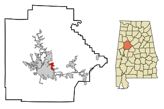
Vance is a town in Tuscaloosa and Bibb counties in the U.S. state of Alabama. As of the 2010 census it had a population of 1,529. It is most famous for the Mercedes-Benz U.S. International plant, currently the only one in North America. The current mayor of Vance is Brenda Morrison.

<span class="mw-page-title-main">Coosada, Alabama</span> Town in Elmore County, Alabama, United States

Coosada is a town in Elmore County, Alabama, United States. At the 2020 census, the population was 1,217. It is part of the Montgomery Metropolitan Statistical Area.

<span class="mw-page-title-main">Berry, Alabama</span> Town in Alabama, United States

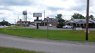
Berry is a town in Fayette County, Alabama, United States. At the 2010 census the population was 1,148, down from 1,238 at the 2000 census.

<span class="mw-page-title-main">Fayette, Alabama</span> City in and county seat of Fayette County, Alabama

Fayette is a city and the county seat of Fayette County, Alabama, United States. The population was 4,619 at the 2010 census, down from 4,922 at the 2000 census.

<span class="mw-page-title-main">Moundville, Alabama</span> Town in Alabama, United States

Moundville is a town in Hale and Tuscaloosa counties in the U.S. state of Alabama. It was incorporated on December 22, 1908. From its incorporation until the 1970 census, it was wholly within Hale County. At the 2010 census the population was 2,427, up from 1,809 at the 2000 census. It is part of the Tuscaloosa Metropolitan Statistical Area. Within the town is Moundville Archaeological Site, the location of a prehistoric Mississippian culture political and ceremonial center.

<span class="mw-page-title-main">Tarrant, Alabama</span> City in Alabama, United States

Tarrant is a city in Jefferson County, Alabama, bordering Birmingham to the north. At the 2020 census, the population was 6,124. It is home to the ABC Coke plant owned by the Drummond Company, "the largest single producer of foundry coke in the U.S.".

<span class="mw-page-title-main">Dayton, Alabama</span> Town in Alabama, United States

Dayton is a town in Marengo County, Alabama, United States. The population was 28 at the 2020 census.

<span class="mw-page-title-main">Linden, Alabama</span> City in Alabama, United States

Linden is a city in and the county seat of Marengo County, Alabama, United States. The population was 1,930 at the 2020 census, down from 2,123 at the 2010 census.

<span class="mw-page-title-main">Brookwood, Alabama</span> City in Alabama, United States

Brookwood is a city in Tuscaloosa County, Alabama, United States. It incorporated in September 1977. As of the 2020 census, the population of the town is 2,504.

<span class="mw-page-title-main">Coker, Alabama</span> Town in Alabama, United States

Coker is a town in Tuscaloosa County, Alabama, United States. It incorporated in 1999. At the 2020 census, the population was 904. It is part of the Tuscaloosa, Alabama Metropolitan Statistical Area.

<span class="mw-page-title-main">Holt, Alabama</span> Census-designated place & Unincorporated community in Alabama, United States

Holt is an unincorporated community and census-designated place (CDP) in Tuscaloosa County, Alabama, United States. At the 2020 census, the population was 3,413. It is part of the Tuscaloosa, Alabama Metropolitan Statistical Area. Holt appeared on the 1930 census.

<span class="mw-page-title-main">Lake View, Alabama</span> City in Alabama, United States

Lake View is a city in Alabama, United States, with the majority in Tuscaloosa County and with a small portion in Jefferson County. At the 2010 census the population was 1,943, up from 1,357 in 2000. It is part of the Tuscaloosa Metropolitan Statistical Area and the Birmingham metropolitan area. It is located approximately halfway between Tuscaloosa and Birmingham via Interstates 20 and 59.

<span class="mw-page-title-main">Jasper, Alabama</span> City in Alabama, United States

Jasper is a city in and the county seat of Walker County, Alabama, United States. Its population was 14,352 as of the 2010 census. Named in honor of Sergeant William Jasper, an American Revolutionary War hero, Jasper was settled around 1815 and incorporated on August 18, 1886.

<span class="mw-page-title-main">Dunlap, Tennessee</span> City in Tennessee, United States

Dunlap is a city in and the county seat of Sequatchie County, Tennessee, United States. The population was 5,357 at the 2020 census and 4,815 at the 2010 census.

<span class="mw-page-title-main">Woodstock, Alabama</span> Town in Alabama, United States

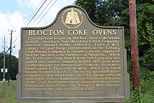
Woodstock is a town in Bibb and Tuscaloosa counties in the U.S. state of Alabama. Formerly known as North Bibb, by referendum in August 2000, the town adopted the name of a long-established local unincorporated community and, as of October 1, 2000, is now known officially as "Woodstock". As of the 2010 census, the population of the town was 1,428.

References

  1. "2020 U.S. Gazetteer Files". United States Census Bureau. Retrieved October 29, 2021.
  2. 1 2 3 4 Dewitt, Robert (March 10, 2002). "West Blocton may not be thriving, but residents' ties are strong". Tuscaloosa News . Retrieved January 2, 2020.
  3. "US Gazetteer files: 2010, 2000, and 1990". United States Census Bureau. February 12, 2011. Retrieved April 23, 2011.
  4. "Geographic Identifiers: 2010 Demographic Profile Data (G001): West Blocton town, Alabama". U.S. Census Bureau, American Factfinder. Archived from the original on February 12, 2020. Retrieved September 16, 2013.
  5. "U.S. Decennial Census". Census.gov. Retrieved June 6, 2013.
  6. "Annual Estimates of the Resident Population: April 1, 2010 to July 1, 2013" . Retrieved June 3, 2014.
  7. "Explore Census Data". data.census.gov. Retrieved December 11, 2021.
  8. "U.S. Census website". United States Census Bureau . Retrieved July 8, 2015.
  9. "CENTREVILLE PRESS - Bibblogger: West Blocton Man's Unique Story leads to Sought After Inventions". February 16, 2021.
  10. Climate Summary for West Blocton, Alabama

33°07′07″N87°07′22″W / 33.118733°N 87.122875°W / 33.118733; -87.122875