Chalk Farm is a small urban district of north west London, lying immediately north of Camden Town, in the London Borough of Camden.
Hampstead is an area in London, England, which lies four miles northwest of Charing Cross, and extends from the A5 road to Hampstead Heath, a large, hilly expanse of parkland. The area forms the northwest part of the London Borough of Camden, a borough in Inner London which for the purposes of the London Plan is designated as part of Central London.

West Hampstead is a London Underground station in West Hampstead. It is located on West End Lane between Broadhurst Gardens and Blackburn Road and is situated in Travelcard Zone 2. It is on the Jubilee line between Kilburn and Finchley Road stations. It is 100 m (110 yd) from West Hampstead station on the London Overground North London line and 200 m (220 yd) from West Hampstead Thameslink station. Metropolitan line trains also pass through the station, but do not usually stop.

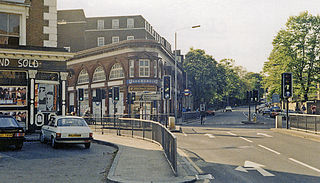
Swiss Cottage is an area of Hampstead in the London Borough of Camden, England. It is centred on the junction of Avenue Road and Finchley Road and includes Swiss Cottage tube station. Swiss Cottage lies 3.25 miles (5.23 km) north-northwest of Charing Cross. The area was named after a public house in the centre of it, known as "Ye Olde Swiss Cottage".
West Hampstead is an area in the London Borough of Camden in north-west London. Mainly defined by the railway stations of the same name, it is situated between Childs Hill to the north, Frognal and Hampstead to the north-east, Swiss Cottage to the east, South Hampstead to the south-east, Kilburn to the west and south-west, and Cricklewood to the north-west. The area is mainly residential with several small shops, restaurants, cafes, bakeries concentrated on the northern section of West End Lane and around West End Green. It is served by three stations: West Hampstead on the Jubilee line, West Hampstead Overground station and West Hampstead Thameslink station. It is part of the Kilburn postal district (NW6).

Ossington Street is a quiet one-way street in London, W2, leading from Moscow Road at its north end to the Bayswater Road / Notting Hill Gate at its south end.

Bayswater Road is the main road running along the northern edge of Hyde Park in London. Originally part of the A40 road, it is now designated part of the A402 road.
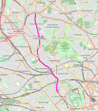
Finchley Road is a designated 4.5-mile (7-kilometre) arterial road in north-west London, England. The Finchley Road starts in St John's Wood near central London as part of the A41; its southern half is a major dual carriageway with high traffic levels often frequented by lorries and long-distance coaches as it connects central London, via the A41 Hendon Way, to the M1 motorway at Brent Cross and other roads at that interchange.
Childs Hill is one of two areas at the south end of the London Borough of Barnet along with Cricklewood which straddles three boroughs. It took its name from Richard le Child, who in 1312 held a customary house and "30 acres" of its area. It is a mainly late-19th-century suburban large neighbourhood centred 5 miles (8 km) northwest of Charing Cross bordered by the arterial road Hendon Way in the west and south-west, Dunstan Road in the north, West Heath and Golders Hill Park which form an arm of Hampstead Heath to the east and the borough boundary as to the short south-east border.
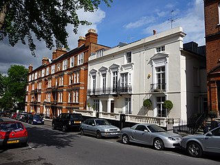
South Hampstead is an affluent part of the London Borough of Camden in inner north London. It is commonly defined as the area between West End Lane in the west, the Chiltern Main Line (south), Broadhurst Gardens north and north-west followed by a non-road line demarcating the south slopes of Hampstead village, west of Belsize Park, and north and west of the usually narrowly defined Swiss Cottage neighbourhood. It takes in some of Fitzjohns Avenue leading up to "the village", but the exact amount is an arbitrary measure.

Leinster Gardens is a street in Bayswater, London. It is lined with tall, ornate, mid-Victorian terraced houses, many of which are listed buildings.

The New Road was a toll road built across fields around the northern boundaries of London, the first part of which opened in 1756. The route comprises the modern-day A501.
The Hampstead Junction Railway was a railway line in north-west London, England, opened in 1860. It connected the existing North London Railway at Camden with the North and South Western Junction Railway. It ran through open country but encouraged residential building, providing passenger train connections with the City of London, as well as connecting other lines. It was absorbed by the North London Railway in 1867. Its route remains in use today with the passenger trains of the North London Line as well as heavy freight traffic.
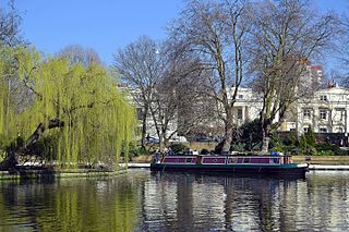
Little Venice is an affluent residential district in West London, England, around the junction of the Paddington Arm of the Grand Union Canal, the Regent's Canal, and the entrance to Paddington Basin. The junction forms a triangular shape basin. Many of the buildings in the vicinity are Regency white painted stucco terraced town houses and taller blocks (mansions) in the same style. The area is 2.5 miles (4.0 km) west-north-west of Charing Cross and immediately north-west of Paddington.

Cleveland Square is a private and gated garden square in the predominantly classically conserved Bayswater district of the City of Westminster, north of Central London's Hyde Park. The housing is in tall, tree-shaded rows, stuccoed and with pillared porches, with some discreet infilling of other housing behind.

Finchley Road was an authorised but unbuilt railway station in Frognal, north London planned by the Metropolitan and St John's Wood Railway (M&StJWR).

Sussex Gardens is located in Paddington in Central London. It is a street that runs runs westwards from the Edgware Road, for most of the way as a broad avenue until it reaches an area near Lancaster Gate where it becomes a garden square. Part of the City of Westminster, it is located in the residential area of Tyburnia north of Hyde Park. Streets running off it include Westbourne Terrace, Talbot Square, London Street and Southwick Street. Sussex Gardens provides the main axis for the area.
Sutherland Avenue is a street in Maida Vale in London, England. Located in the City of Westminster on the northern edge of Little Venice. it is an avenue running east to west from the Edgware Road to Harrow Road. Along the route it is crossed or joined by Randolph Avenue, Warrington Crescent, Lauderdale Road, Castellian Road, Warwick Avenue and Shirland Road. Elgin Avenue runs directly parallel to the north.

Connaught Street is a street in Central London. Located in the City of Westminster, it is part of the Tyburnia area of Paddington north of Hyde Park. It runs west to east from Hyde Park Square to the Edgware Road. It continues eastwards becoming Upper Berkeley Street in Marylebone. The street contains a mixture of commercial and residential properties, forming part of Connaught Village. Connaught Square and Albion Street are located on its southern side. The Duke of Kendal public house sits at the junction between Connaught Street and Kendal Street.
Hampstead Square is located in Hampstead in the London Borough of Camden. It runs eastward off Heath Street and then curves southwards before Elm Row connects it again to Heath Street. It is linked by pedestrian access to Cannon Place.


