West Hampstead railway station

Last updated

West Hampstead Overground roundel (no text).svg
West Hampstead Overground Station (geograph 6510672).jpg
Greater London UK location map 2.svg
Red pog.svg
West Hampstead
Location of West Hampstead in Greater London
Location West Hampstead
Local authority London Borough of Camden
Managed by London Overground
Owner Network Rail
Station codeWHD
DfT category D
Number of platforms2
AccessibleYes [1]
Fare zone 2
OSI West Hampstead Underground no-text.svg
West Hampstead Thameslink ThameslinkSymbol.svg [2]
National Rail annual entry and exit
2018–19Decrease2.svg 4.521 million [3]
– interchange Decrease2.svg 0.650 million [3]
2019–20Decrease2.svg 4.044 million [3]
– interchange Increase2.svg 0.665 million [3]
2020–21Decrease2.svg 1.554 million [3]
– interchange Decrease2.svg 0.200 million [3]
2021–22Increase2.svg 2.898 million [3]
– interchange Increase2.svg 0.447 million [3]
2022–23Increase2.svg 3.297 million [3]
– interchange Increase2.svg 0.828 million [3]
Key dates
1 March 1888Opened
Other information
External links
Coordinates 51°32′50″N0°11′30″W / 51.5473°N 0.1918°W / 51.5473; -0.1918
Underground sign at Westminster.jpg  London transportportal

West Hampstead railway station is a London Overground station on the North London Line between Brondesbury and Finchley Road & Frognal in the London Borough of Camden and is in Travelcard Zone 2.

Contents

The station and all trains are operated by London Overground. The station entrance is on West End Lane.

History

The station opened on 1 March 1888 and was called West End Lane until 1975, when it became West Hampstead (making it one of three stations of essentially the same name along West End Lane). [4] The train service was provided by the North London Railway until 1909, when management of the NLR was taken over by the London and North Western Railway. Complete amalgamation with the LNWR followed in 1922, and the LNWR then amalgamated with other railways to form the LMS from January 1923. The LMS became the London Midland Region of British Railways on nationalisation in 1948, and the shortened brand name British Rail was used from 1965. The station and the rest of the North London Line was included in the reorganised BR business Network SouthEast in 1986.

Following the privatisation of British Rail, the station was managed by the Silverlink franchise (National Express) from 1997 until 2007, when operations passed to Transport for London's new London Overground.

After privatisation, Anglia Railways ran a regional service for a while between Norwich and Basingstoke which called here. This service, known as London Crosslink, was discontinued in Autumn 2002 because of a shortage of train paths on the North London Line and the financial return being less than forecast.[ citation needed ]

The station was initially refurbished towards the end of 2007, to coincide with the takeover of the line by London Overground.

The station was comprehensively upgraded in the late 2010s thanks in part to the adjacent Ballymore West Hampstead Square development. [5] [6] The upgrade included a new station building, wider platforms and step free access, [7] and was completed in December 2019. [8]

Accidents and incidents

Interchanges

Stations in West Hampstead
BSicon CONTg.svg
BSicon numN090.svg
BSicon STR.svg
BSicon uvCONTg.svg
BSicon STR.svg
BSicon uvSTR.svg
BSicon CONTg.svg
BSicon dCONTgq.svg
BSicon KRZo.svg
BSicon MSTR.svg
BSicon uvBRUCKE1.svg
BSicon STRq.svg
BSicon STR+r.svg
BSicon STR.svg
BSicon HUBrg-R.svg
BSicon STR.svg
BSicon HUB-Lq.svg
BSicon uvSTR.svg
BSicon lBHF-.svg
BSicon HUB-Lq.svg
BSicon STR.svg
BSicon l-BHF.svg
BSicon HUBlg-L.svg
BSicon STR.svg
Overground roundel (no text).svg London Overground station
ThameslinkSymbol.svg Thameslink station
BSicon HUB-R.svg
BSicon SKRZ-G2u.svg
BSicon uvSKRZ-G2u.svg
BSicon SKRZ-G2u.svg
BSicon HUB-L.svg
BSicon SKRZ-G2u.svg
West Hampstead
BSicon HUBlf-R.svg
BSicon STR.svg
BSicon HUB-Rq.svg
BSicon uvBHF-STR.svg
BSicon HUB-Rq.svg
BSicon STR.svg
BSicon HUBrf-L.svg
BSicon STR.svg
BSicon STR.svg
BSicon uvSTR.svg
BSicon STR2.svg
BSicon STR3u.svg
BSicon STR.svg
BSicon HUB2.svg
BSicon uvBHF.svg
BSicon HUBc3.svg
BSicon STR+1u.svg
BSicon STR+4.svg
Jubilee line roundel (no text).svg Metropolitan line roundel (no text).svg Finchley Road
OSI: Overground roundel (no text).svg
BSicon STR.svg
BSicon HUBc1.svg
BSicon uvSTR.svg
BSicon HUB2+4.svg
BSicon eBHF.svg
BSicon HUBc3.svg
BSicon STR.svg
Finchley Road
(MR) (1868–1927)
BSicon STR.svg
BSicon uvSTR.svg
BSicon HUBc1.svg
BSicon STR.svg
BSicon HUB4.svg
BSicon BHF.svg
Overground roundel (no text).svg Finchley Road & Frognal
OSI: Jubilee line roundel (no text).svg Metropolitan line roundel (no text).svg
BSicon STR.svg
BSicon uvSTR.svg
BSicon STR.svg
BSicon CONTl+g.svg
BSicon STR.svg
BSicon uvSTR.svg
BSicon CONTf.svg
BSicon STR.svg
BSicon uvCONTf.svg
BSicon CONTf.svg

West Hampstead railway station has an out of station interchange with both West Hampstead Thameslink railway station and West Hampstead Underground station. The arrangement of three separate stations (Thameslink, Overground and Jubilee Line) means that passengers wishing to change lines must walk along or cross West End Lane, a busy main road.

Development

A West Hampstead interchange proposal was put forward in 2004 by Chiltern Railways which would link the three West Hampstead stations with subterranean walkways. New platforms would be built for the Chiltern Main Line, and possibly also for the Metropolitan line, and the Thameslink and London Overground (formerly Silverlink) stations would be relocated on the east side of West End Lane. [10] The redevelopment would involve demolishing existing buildings and the redevelopment of West End Lane as "a tree-lined boulevard". [11] [12] The plans were put on hold in 2007 due to uncertainty over the North London Line rail franchise. [13] This has now been shelved with Network Rail instead redeveloping the Thameslink station by installing a second footbridge with lift access leading to a new station building on Iverson Road. [14]

In early 2008, the London Group of the Campaign for Better Transport published a plan [15] for an off-road, mainly orbital North and West London Light Railway, sharing the orbital Dudding Hill Line freight corridor, and taking over at least one of the two Midland Railway freight lines which run through the neighbouring West Hampstead Thameslink station.

Connections

London Buses routes 139, 328 and C11 serve the station.

Services

All services at West Hampstead are operated by London Overground using Class 378 EMUs.

The typical off-peak service in trains per hour is: [16] [17]

During the late evenings, the services to and from Clapham Junction do not operate.

Preceding station Overground notextroundel.svg National Rail logo.svg London Overground Following station
Brondesbury North London line Finchley Road & Frognal
towards Stratford
Historical Railways
Anglia Railways

Related Research Articles

<span class="mw-page-title-main">North London line</span> Railway line in London

The North London line (NLL) is a railway line which passes through the inner suburbs of west, north-west, north, and north-east London, England between Richmond in the south-west and Stratford in the east, avoiding central London. Its route is a rough semicircle.

<span class="mw-page-title-main">Willesden Junction station</span> London Underground and London Overground station

Willesden Junction is an interchange station located in Harlesden, north-west London, for London Underground and London Overground services. The station also borders the London Borough of Ealing, near the Old Oak Lane conservation area in the East Acton ward.

<span class="mw-page-title-main">Wembley Central station</span> London Underground and railway station

Wembley Central is an interchange station in Wembley, North West London for London Underground and London Overground services on the Watford DC line and National Rail services on the West Coast Main Line.

<span class="mw-page-title-main">Brondesbury railway station</span> London Overground station

Brondesbury is on the North London line, on a viaduct crossing Kilburn High Road in the Brondesbury area of Kilburn in the London Borough of Brent in north-west London.

<span class="mw-page-title-main">Brockley railway station</span> National rail station in London, England

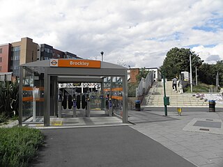
Brockley railway station serves the south-east London district of Brockley and is on the main railway line between London Bridge and Brighton. It is 3 miles 56 chains down the line from London Bridge.

<span class="mw-page-title-main">Peckham Rye railway station</span> National rail station in London, England

Peckham Rye is a railway station in Peckham town centre, South London. The station is served by Southern, London Overground, Southeastern and Thameslink.

<span class="mw-page-title-main">Gospel Oak railway station</span> London Overground station

Gospel Oak railway station is in the London Borough of Camden in north-west London. It is situated the North London line, served by Mildmay line services between Clapham Junction/Richmond and Stratford, and is also the western passenger terminus of the Gospel Oak to Barking line, served by Suffragette line services to/from Barking Riverside. Passengers using Oyster cards are required to tap on interchange Oyster card readers when changing between the two lines. The station is in Travelcard Zone 2, and is managed by London Overground which runs all passenger trains at the station.

The North London Railway (NLR) company had lines connecting the northern suburbs of London with the East and West India Docks further east. The main east to west route is now part of London Overground's North London Line. Other NLR lines fell into disuse but were later revived as part of the Docklands Light Railway, and London Overground's East London Line. The company was originally called the East & West India Docks & Birmingham Junction Railway (E&WID&BJR) from its start in 1850, until 1853. In 1909, it entered into an agreement with the London and North Western Railway which introduced common management, and the NLR was taken over completely by the LNWR in 1922. The LNWR itself became part of the LMS from the start of 1923. The railways were nationalised in 1948 and most LMS lines, including the North London route, then came under the control of the London Midland Region of British Railways.

<span class="mw-page-title-main">Brondesbury Park railway station</span> London Overground station

Brondesbury Park railway station is a National Rail station in Brondesbury Park in the London Borough of Brent on the North London line in Travelcard Zone 2 which is managed by London Overground. It is close to the Queen's Park area.

West Hampstead is an area in north-west London, England that is served by a number of different stations, all of which have very similar names. Although physically separate, they are near each other and the stations form a railway interchange. Two of the stations are part of the National Rail network and the third is on the London Underground.

<span class="mw-page-title-main">Hampstead Heath railway station</span> London Overground station in the London Borough of Camden

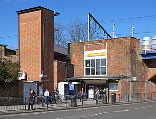
Hampstead Heath railway station is in the London Borough of Camden in north London on the North London Line, between Finchley Road & Frognal and Gospel Oak stations, and is in Travelcard Zone 2. Since 11 November 2007 it and the service there have been run by London Overground. It is located on South End Road close to South End Green and Pond Street in the old South End of Hampstead.

<span class="mw-page-title-main">West London line</span> Clapham Junction-Willesden Junction rail route

The West London line (WLL) is a short railway in inner West London that links Willesden Junction in the north to Clapham Junction in the south. The line has always been an important cross-London link, especially for freight services. Southern and London Overground provide regular passenger services; detailed below.

<span class="mw-page-title-main">Honor Oak Park railway station</span> National rail station in London, England

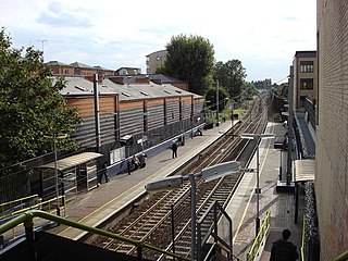
Honor Oak Park railway station serves the suburban area of Honor Oak in the London Borough of Lewisham. It is 4 miles 59 chains down the line from London Bridge, between Brockley and Forest Hill.

<span class="mw-page-title-main">Finchley Road & Frognal railway station</span> London Overground station

Finchley Road & Frognal railway station is on Finchley Road in the London Borough of Camden in north London. It is on the North London line, and the station and all trains serving it are operated by London Overground. It is in Travelcard Zone 2. The station is about five minutes walk from Finchley Road Underground station, and is marked as an official out-of-system interchange. The station was opened as Finchley Road St Johns Wood in 1860 on the Hampstead Junction Railway for the connection to the North London Railway.

<span class="mw-page-title-main">Cricklewood railway station</span> National Rail station in London, England

Cricklewood railway station is on the Midland Main Line in England, serving the town of Cricklewood in the London Borough of Barnet, north London. It is 5 miles 9 chains (8.2 km) down the line from St Pancras and is situated between West Hampstead Thameslink to the south and Brent Cross West to the north. Its three-letter station code is CRI.

<span class="mw-page-title-main">Hendon railway station</span> National Rail station in London, England

Hendon railway station is on the Midland Main Line in England, in West Hendon in the London Borough of Barnet, north London. It is 6 miles 79 chains (11.2 km) down the line from St Pancras and is situated between Brent Cross West to the south and Mill Hill Broadway to the north. Its three-letter station code is HEN.

<span class="mw-page-title-main">Watford DC line</span> London Overground line

The Watford DC line is a suburban line from London Euston to Watford Junction in Watford, Hertfordshire. Its services are operated by London Overground. In February 2024 TfL announced a re-branding as the Lioness line.

<span class="mw-page-title-main">London Overground</span> London suburban rail network

London Overground is a suburban rail network serving London and its environs. Established in 2007 to take over Silverlink Metro routes, it now serves a large part of Greater London as well as Hertfordshire, with 113 stations on the six lines that make up the network.

<span class="mw-page-title-main">Shepherd's Bush railway station</span> London Overground station

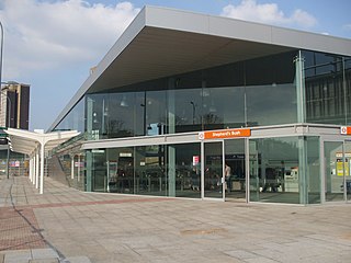
Shepherd's Bush station is a station located in the district of Shepherd's Bush in Greater London for London Overground and National Rail services.

<span class="mw-page-title-main">Old Oak Common Lane railway station</span> Proposed railway station in London, England

Old Oak Common Lane railway station is a proposed railway station in West London, UK. If constructed, it will be situated on the North London Line, between Acton Central and Willesden Junction, within the London Overground commuter rail system. Old Oak Common Lane station would be situated about 400 yards to the west of the planned Old Oak Common railway station and will offer interchange between London Overground and other rail services, including National Rail, Crossrail and High Speed 2. It is one of two proposed new stations which will connect with Old Oak Common, the other being Hythe Road on the West London line.

References

  1. "London Overground's West Hampstead station becomes step-free". Transport for London. Retrieved 26 February 2020.
  2. "Out-of-Station Interchanges" (Microsoft Excel). Transport for London. 2 January 2016. Retrieved 28 August 2016.
  3. 1 2 3 4 5 6 7 8 9 10 "Estimates of station usage". Rail statistics. Office of Rail Regulation. Please note: Some methodology may vary year on year.
  4. Joe Brown (2006). London Railway Atlas. Ian Allan Publishing.
  5. Turton, Jonathan (12 July 2013). "New Overground station to be built next year". West Hampstead Life. Retrieved 26 February 2020.
  6. "West Hampstead Square | Ballymore". ballymoregroup.com. Retrieved 26 February 2020.
  7. "London Overground's West Hampstead station becomes step-free". Transport for London. Retrieved 26 February 2020.
  8. "Work to improve London Overground's West Hampstead station is complete". Transport for London. Retrieved 26 February 2020.
  9. Trevena, Arthur (1980). Trains in Trouble. Vol. 1. Redruth: Atlantic Books. p. 40. ISBN   0-906899-01-X.
  10. "Planning Framework for West Hampstead Interchange Area Appendix 2". London Borough of Camden. 19 April 2005. p. 25. Archived from the original on 11 June 2011. Retrieved 29 July 2008.
  11. "West Hampstead Interchange". AlwaysTouchOut.com. 11 January 2006. Retrieved 29 July 2008.
  12. "West Hampstead Interchange Draft Planning Framework". London Borough of Camden. 19 April 2005. Archived from the original on 24 October 2007. Retrieved 29 July 2008.
  13. "Station interchange plans put on hold". Camden New Journal. 15 March 2007. Retrieved 29 July 2008.
  14. "Thameslink station redevelopment gets go-ahead". New Civil Engineer. Retrieved 18 September 2016.
  15. London Campaign for Better Transport North and West London light railway (NWLLR) / Brent Cross Railway (BCR) plan
  16. Table 59 National Rail timetable, December 2023
  17. "London Overground Timetable: Richmond and Clapham Junction to Stratford" (PDF). Transport for London . Retrieved 22 January 2024.