Related Research Articles

Las Animas is the Statutory City that is the county seat, the most populous community, and the only incorporated municipality in Bent County, Colorado, United States. The city population was 2,410 at the 2010 United States Census. Las Animas is located on the Arkansas River, just west of its confluence with the Purgatoire River, in southeast Colorado east of Pueblo, near the historic Bent's Fort.

The Mojave River is an intermittent river in the eastern San Bernardino Mountains and the Mojave Desert in San Bernardino County, California, United States. Most of its flow is underground, while its surface channels remain dry most of the time, with the exception of the headwaters and several bedrock gorges in the lower reaches.

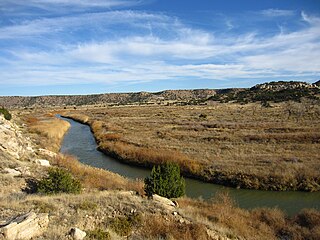
Animas River is a 126-mile-long (203 km) river in the western United States, a tributary of the San Juan River, part of the Colorado River System.
South-Central Colorado is a region of the U.S. state of Colorado. It can be roughly defined by Chaffee County in the northwest, El Paso County in the northeast, Las Animas County in the southeast, and Conejos County in the southwest. Some notable towns and cities there include Colorado Springs, Pueblo, Cripple Creek, Cañon City, Salida, Buena Vista, Monte Vista, Alamosa, Walsenburg, and Trinidad. The landscapes of South-Central Colorado were made known to the Western world by the explorations of Zebulon Pike and Kit Carson, who were later followed by settlers, many of whom came by the Santa Fe Trail. The upper tributaries of the Arkansas River and South Platte River provide ample whitewater rafting and are famous for trout and bass fishing in scenic settings such as Royal Gorge. Much of the local economic system is dependent on mining, forestry, ranching, and tourism related to these endeavors. South-Central Colorado has so far largely escaped urbanization, allowing visitors to experience something of the American Old West.

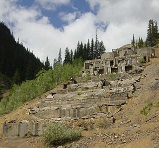
Animas Forks is a ghost town located twelve miles (19 km) northeast of Silverton in San Juan County, Colorado, United States. The area is managed by the Bureau of Land Management. At over 11,000 feet, Animas Forks is one of the highest mining camps in the Western US.

Weston is an unincorporated town, a post office, and a census-designated place (CDP) located in and governed by Las Animas County, Colorado, United States. The Weston post office has the ZIP Code 81091. At the United States Census 2010, the population of the Weston CDP was 55, while the population of the 81091 ZIP Code Tabulation Area was 812 including adjacent areas.
The Narrows is a strait in New York City separating Brooklyn and Staten Island.
Animas may refer to:
Eureka is a mining ghost town in San Juan County, Colorado, United States, along the Animas River, between Silverton and Animas Forks. The town derives its name from the Greek interjection Eureka!

The Silverton Northern Railroad, now defunct, was an American 3 ft Narrow Gauge Railroad constructed to reach the mining area north of Silverton, Colorado along the upper Animas River. This line was the third railroad project built by known Colorado toll road builder and Russian Immigrant Otto Mears, beginning in 1889 as a branch of the Silverton Railroad to Eureka. Incorporated in 1895 as the Silverton Northern Railroad, the line was projected to run past Eureka to Animas Forks and on to Mineral Point and then on to Lake City via Henson Creek, including a proposed three-quarter-mile tunnel through the mountains. However, Animas Forks was the end of the line, which was reached in 1896.
The Purgatoire River is a river in southeastern Colorado, United States. The river is also known locally as the Purgatory River or the Picketwire River. Purgatoire means Purgatory in French. French trappers named the river to commemorate Spanish explorers killed in a Native American attack.

The Alpine Loop Back Country Byway is a rugged 63-mile (101 km) Back Country Byway and Colorado Scenic and Historic Byway located in the high San Juan Mountains of Hindale, Ouray, and San Juan counties, Colorado, USA. The byway connects the mountain towns of Lake City, Ouray, and Silverton. The route ranges in elevation from 7,792 feet (2,375 m) in Ouray to 12,800 feet (3,901 m) at Engineer Pass. The byway features high mountain passes, alpine tundra, beautiful mountain meadows, ghost towns, and relics of the silver mining era. While the meadows and tundra are accessible to ordinary passenger vehicles, a high-clearance 4-wheel drive vehicle is required to travel the entire route.
North Fork Vermejo River is a tributary of the Vermejo River. The river flows from Las Animas County, Colorado south to a confluence with Little Vermejo Creek in Colfax County, New Mexico that forms the Vermejo River.
North Fork Animas River is a tributary of the Animas River in San Juan County, Colorado. It flows south to a confluence with the West Fork Animas River that forms the Animas River.
South Fork Animas River is a tributary of the Animas River in San Juan County, Colorado. It flows from a source near Tower Mountain to a confluence with the Animas River.

Stonewall Gap is an unincorporated community and a census-designated place (CDP) located in and governed by Las Animas County, Colorado, United States. The population of the Stonewall Gap CDP was 67 at the United States Census 2010. The Weston post office serves the area.
References
- ↑ "West Fork Animas River". Geographic Names Information System . United States Geological Survey . Retrieved 2013-06-08.
| | This article related to a river in Colorado is a stub. You can help Wikipedia by expanding it. |