Anderson County is a county located in the U.S. state of South Carolina. As of the 2020 census, its population was 203,718. Its county seat is Anderson. Named for Revolutionary War leader Robert Anderson, the county is located in northwestern South Carolina, along the state line of Georgia. Anderson County is included in the Greenville-Anderson-Greer, SC Metropolitan Statistical Area. Anderson County contains 55,950-acre (22,640 ha) Lake Hartwell, a U.S. Army Corps of Engineers lake with nearly 1,000 miles (1,600 km) of shoreline for residential and recreational use. The area is a growing industrial, commercial and tourist center. It is the home of Anderson University, a private, selective comprehensive university of approximately 4,000 undergraduate and graduate students.
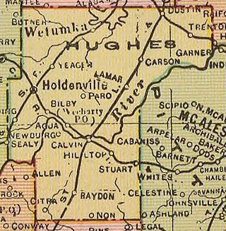
Hughes County is a county located in south central U.S. state of Oklahoma. As of the 2020 census, the population was 13,367. Its county seat is Holdenville. The county was named for W. C. Hughes, an Oklahoma City lawyer who was a member of the Oklahoma Constitutional Convention.
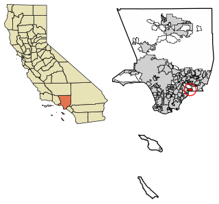
La Habra Heights is a city in Los Angeles County, California, United States. The population was 5,325 at the 2010 census, down from 5,712 at the 2000 census. La Habra Heights is a suburban canyon community located on the border of Orange and Los Angeles counties. The zoning is 1-acre (4,000 m2) lots with a variety of home and ranch style properties. La Habra Heights features open space and there are no sidewalks in the community. La Habra Heights has no commercial activity with few exception. Hacienda Park is the main park in the city and runs along Hacienda Road.

Harpswell is a town in Cumberland County, Maine, United States, within Casco Bay in the Gulf of Maine. The population was 5,031 at the 2020 census. Harpswell is composed of land contiguous with the rest of Cumberland County, called Harpswell Neck, as well as three large islands connected by bridges: Sebascodegan Island, Orr's Island, and Bailey Island and over 200 smaller islands. Harpswell is part of the Portland–South Portland–Biddeford, Maine Metropolitan Statistical Area.

Ravena is a village in Albany County, New York, United States. The population was 3,271 in the 2020 census an increase of 3 over the 2010 census. The village is in the southeast part of the town of Coeymans.

Hanover is a town in Chautauqua County, New York, United States. The population was 6,893 at the 2020 census. The town lies in the northeast corner of Chautauqua County.
West Bloomfield is a town in Ontario County, New York, United States. The population was 2,760 at the 2020 census.

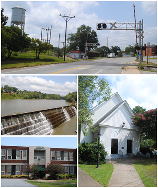
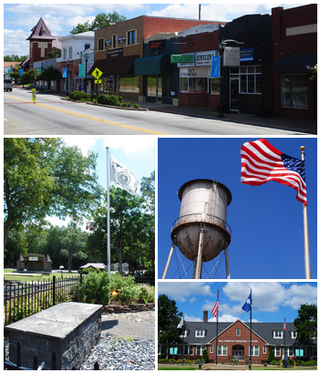
Williamston is a town and the county seat of Martin County, North Carolina, United States. The population was 5,248 at the 2020 census. It is located in North Carolina's Inner Banks region. The closest major city is Greenville, approximately 28 miles (45 km) to the southwest.

Ostrander is a village in Delaware County, Ohio, United States. The population was 1,094 at the 2020 census.

North Braddock is a borough in Allegheny County, Pennsylvania, United States, along the Monongahela River. The 2020 census had the borough population at 4,320. It is a suburb 11 miles (18 km) east of Pittsburgh. Organized from a part of Braddock Township in 1897, the borough prides itself in being the "Birthplace of Steel" as the home of Andrew Carnegie's Edgar Thomson Steel Works that opened in 1875.

North Versailles is a first class township in Allegheny County, Pennsylvania, United States. The population was 10,079 at the 2020 census. The township derives its name from the Palace of Versailles.

Hollidaysburg is a borough in and the county seat of Blair County in the U.S. Commonwealth of Pennsylvania. It is located on the Juniata River, 5 miles (8 km) south of Altoona and is part of the Altoona, Pennsylvania, metropolitan statistical area. In 1900, 2,998 people lived in the borough, in 1910, 3,734 lived there, and in 1940, 5,910 residents were counted. The population was 5,641 at the 2020 census. Coal, iron ore, ganister, and limestone are found in the vicinity. In the past, the borough had foundries and machine shops, a silk mill, car works and classification yards.

West York is a borough, adjacent to the City of York, in York County, Pennsylvania, United States. The population was 5,094 at the 2020 census.
Pelzer is a town in Anderson County, South Carolina, United States, along the Saluda River. The population was 89 at the 2010 census, and grew to 1,344 at the 2020 census.
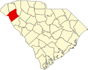
Williamston is a town in Anderson County, South Carolina. The population was 4,043 at the 2020 census.

Easley is a city in Pickens County in the U.S. state of South Carolina. Most of the city lies in Pickens County, with a small portion of the city in Anderson County.

Shavano Park is a city located in Bexar County, Texas, United States. As of the 2020 census, the population was 3,524, an increase over the figure of 3,035 tabulated in 2010. It is part of the San Antonio Metropolitan Statistical Area, despite being much different in terms of demographics and having some of the wealthiest families in Bexar County.

Clemson is a city in Pickens and Anderson counties in the U.S. state of South Carolina. Clemson is home to Clemson University; in 2015, the Princeton Review cited the town of Clemson as ranking #1 in the United States for "town-and-gown" relations with its resident university. The population of the city was 17,681 at the 2020 census.
Howland is a town in Penobscot County, Maine, United States, which was settled in 1818. It was named after John Howland, one of the passengers on the Mayflower. The population was 1,094 at the 2020 census.

Canton is a village and county seat of St. Lawrence County, New York, United States. The village is centrally located in both the town of Canton and the county of St. Lawrence. The population was 7,155 at the 2020 census. The name comes from Canton in Cardiff, Wales.