West Yorkshire Built-up Area

Last updated

West Yorkshire Built-up Area
Conurbation
2011 West Yorkshire Built-up Area.svg
2011 map of the West Yorkshire Built-up Area, showing subdivisions
Area487.8 km2 (188.3 sq mi)
Population1,777,934 
  Density 3,645/km2 (9,440/sq mi)
OS grid reference SE455215
Metropolitan county
Region
Country England
Sovereign state United Kingdom
Police West Yorkshire
Fire West Yorkshire
Ambulance Yorkshire
List of places
UK
England
Yorkshire

The West Yorkshire Built-up Area, previously known as the West Yorkshire Urban Area, is a term used by the Office for National Statistics (ONS) to refer to a conurbation in West Yorkshire, England, based on the cities of Leeds, Bradford and Wakefield, and the large towns of Huddersfield and Halifax. It is the 4th largest urban area in the United Kingdom. However, it excludes other towns and villages such as Featherstone, Normanton, Castleford, Pontefract, Hemsworth, Todmorden, Hebden Bridge, Knottingley, Wetherby and Garforth which, though part of the county of West Yorkshire, are considered independently. There are substantial areas of agricultural land within the designated area – more than in any other official urban area in England – many of the towns and cities are only just connected with one another by narrow outlying strips of development.

Urban subdivisions

Map of the main settlements West Yorkshire map.png
Map of the main settlements
Leeds, the largest city in the built-up area (BUA) and the United Kingdom's third-largest city by population Leeds CBD at night.jpg
Leeds, the largest city in the built-up area (BUA) and the United Kingdom's third-largest city by population
Bradford, the second largest city in the BUA and United Kingdom's sixth largest city by population Bradfordskyline.jpeg
Bradford, the second largest city in the BUA and United Kingdom's sixth largest city by population
Huddersfield, a market town with the third-highest population in the BUA and one of the largest market towns in UK Huddersfield (16037400213).jpg
Huddersfield, a market town with the third-highest population in the BUA and one of the largest market towns in UK
Wakefield , the BUA's third city and previously a centre for coal mining, famous for its cathedral, castle and the historical battle of Wakefield Wakefield-1.jpg
Wakefield , the BUA's third city and previously a centre for coal mining, famous for its cathedral, castle and the historical battle of Wakefield
Halifax, a centre for the wool industry since the 1400s and fifth largest settlement in the conurbation, also known for its minster church Halifax- Church, Town Hall ... (2324456809).jpg
Halifax, a centre for the wool industry since the 1400s and fifth largest settlement in the conurbation, also known for its minster church

The ONS gives the conurbation a population of 1,777,934 (2011 census), [1] which makes it the fourth-most populous in the UK. The ONS partitions the area down into 39 sub-divisions: [1]

Three further subdivisions are given [2] with no population numbers as they are present or former industrial areas with no resident population.

Rawdon is the subdivision name for Horsforth Vale, on which a former industrial plant was redeveloped for housing from 2010, too late to be recorded for the 2011 census.

Note that the areas below do not have exactly the same borders in each census, so the numbers are not always comparable (e.g. what was classified as Lofthouse/Stanley in 2001 was classified as part of Wakefield in 2011).

#SubdivisionPopulation 2011Population 2001 [3] Population 1991 [4] Population 1981 [5]
1Leeds474,632443,247424,194445,242
2Bradford349,561293,717289,376293,336
3Huddersfield162,949146,234143,726147,825
4Wakefield99,25176,88673,95574,764
5Halifax88,134
6Dewsbury62,94554,34150,16849,612
7Keighley56,34849,45349,56749,188
8Batley46,933
9Brighouse33,28632,36032,19832,597
10Pudsey32,21632,39131,63631,943
11Morley29,67354,05147,57944,652
12Shipley28,69428,16228,16528,815
13Bingley22,49319,88419,58518,954
14Holmfirth21,706
15Ossett21,23121,07620,40520,417
16Yeadon19,668
17Rothwell19,512
18Mirfield19,33018,39018,45918,599
19Horsforth18,89518,92818,59319,205
20Liversedge17,697
21Baildon15,94415,36815,38514,907
22Otley14,215
23Heckmondwike12,08511,2919,8559,775
24Guiseley11,960
25Cleckheaton11,648
26Horbury10,36110,0029,1869,792
27Burley in Wharfedale7,041
28Haworth6,379
29Thornton5,289
30Sowerby Bridge4,601
31Menston4,3694,6604,8884,865
32Netherton3,686
33Robin Hood3,573
34Walton3,231
35Middlestown2,366
36Scholes2,317
37Bottom Boat1,169
38East Morton1,169
39Carlton842
Guiseley/Yeadon31,38131,10430,811
Cleckheaton and Liversedge26,79627,15126,340
Lofthouse/Stanley22,94719,13617,439
Holmfirth/Honley22,69021,97921,138
Queensbury8,7187,4247,410
Shelf4,4964,2374,204
New Farnley2,548
Total1,777,9341,499,4651,445,9811,467,412
2011 subdivision notes:

Lofthouse merged into Wakefield.
Stanley merged into Wakefield.
Honley merged into Holmfirth.
Queensbury merged into Bradford and Shelf merged into Halifax.

New Farnley merged into Leeds.

Related Research Articles

<span class="mw-page-title-main">West Yorkshire</span> County of England

West Yorkshire is a metropolitan and ceremonial county in the Yorkshire and the Humber region of England. It borders North Yorkshire to the north and east, South Yorkshire and Derbyshire to the south, Greater Manchester to the south-west, and Lancashire to the west. The city of Leeds is the largest settlement.

<span class="mw-page-title-main">Elland</span> Town in West Yorkshire, England

Elland is a market town in Calderdale, in the county of West Yorkshire, England. It is situated south of Halifax, by the River Calder and the Calder and Hebble Navigation. Elland was recorded as Elant in the Domesday Book of 1086. It had a population in 2001 of 14,554, with the ward being measured at 11,676 in the 2011 Census.

<span class="mw-page-title-main">Guiseley</span> Town in West Yorkshire, England

Guiseley is a town in metropolitan borough of the City of Leeds, West Yorkshire, England. Historically part of the West Riding of Yorkshire, it is situated south of Otley and Menston and is now a north-western suburb of Leeds.

<span class="mw-page-title-main">Rothwell, West Yorkshire</span> Market Town in West Yorkshire, England

Rothwell is a town in the south-east of the City of Leeds metropolitan borough in West Yorkshire, England. It is situated between Leeds and Wakefield.

<span class="mw-page-title-main">West Riding of Yorkshire</span> One of the historic subdivisions of Yorkshire, England

The West Riding of Yorkshire was one of three historic subdivisions of Yorkshire, England. From 1889 to 1974 the riding was an administrative county named County of York, West Riding. The lieutenancy at that time included the city of York and as such was named "West Riding of the County of York and the County of the City of York". The riding ceased to be used for administrative purposes in 1974, when England's local government was reformed.

<span class="mw-page-title-main">West Midlands conurbation</span> Conurbation in England

The West Midlands conurbation is the large conurbation in the West Midlands region of England. The area consists of two cities and numerous towns: to the east, the city of Birmingham, along with adjacent towns of Solihull and Sutton Coldfield; and to the west, the city of Wolverhampton and the area called the Black Country, containing the towns of Dudley, Walsall, West Bromwich, Oldbury, Willenhall, Bilston, Darlaston, Tipton, Smethwick, Wednesbury, Rowley Regis, Stourbridge and Halesowen.

<span class="mw-page-title-main">City of Bradford</span> City and metropolitan borough in West Yorkshire, England

Bradford, also known as the City of Bradford, is a metropolitan borough in West Yorkshire, England. It is named after its largest settlement, Bradford, but covers a larger area which includes the towns and villages of Keighley, Shipley, Bingley, Ilkley, Haworth, Silsden, Queensbury, Thornton and Denholme. Bradford has a population of 528,155, making it the fourth-most populous metropolitan district and the sixth-most populous local authority district in England. It forms part of the West Yorkshire Urban Area conurbation which in 2011 had a population of 1,777,934, and the city is part of the Leeds-Bradford Larger Urban Zone (LUZ), which, with a population of 2,393,300, is the fourth largest in the United Kingdom after London, Birmingham and Manchester.

<span class="mw-page-title-main">Nottingham Urban Area</span> Area of land in and around Nottingham, England

The Nottingham Built-up Area (BUA), Nottingham Urban Area, or Greater Nottingham is an area of land defined by the Office for National Statistics as which is built upon, with nearby areas linked if within 200 metres. It consists of the city of Nottingham and the adjoining urban areas of Nottinghamshire and Derbyshire, in the East Midlands of England. It had a total population of 729,977 at the time of the 2011 census. This was an increase of almost 10% since the 2001 census recorded population of 666,358, due to population increases, reductions and several new sub-divisions.

<span class="mw-page-title-main">Halifax (UK Parliament constituency)</span> Parliamentary constituency in the United Kingdom

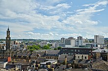
Halifax is a constituency represented in the House of Commons of the UK Parliament since 2015 by Holly Lynch of the Labour Party.

<span class="mw-page-title-main">Queensbury, West Yorkshire</span> Village in West Yorkshire, England

Queensbury is a village in the metropolitan borough and city of Bradford, West Yorkshire, England. Perched on a high vantage point above Halifax, Clayton and Thornton and overlooking Bradford, Queensbury is one of the highest parishes in England, with views beyond the West Yorkshire conurbation to the hills of Brontë Country and the Yorkshire Dales to the north and north west. Its population of 8,718 in 2001 increased to 16,273 in the 2011 Census.

<span class="mw-page-title-main">Greater Manchester Built-up Area</span> Conurbation in England

The Greater Manchester Built-up Area is an area of land defined by the Office for National Statistics (ONS), consisting of the large conurbation that encompasses the urban element of the city of Manchester and the metropolitan area that forms much of Greater Manchester in North West England. According to the United Kingdom Census 2011, the Greater Manchester Built-up Area has a population of 2,553,379 making it the second most populous conurbation in the United Kingdom after the Greater London Built-up Area. This was an increase of 14% from the population recorded at the United Kingdom Census 2001 of 2,240,230, when it was known as the Greater Manchester Urban Area.

<span class="mw-page-title-main">Liverpool Built-up Area</span> Human settlement in United Kingdom

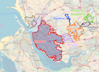
The Liverpool Built-up Area is a term used by the Office for National Statistics (ONS) to denote the urban area around Liverpool in England, to the east of the River Mersey. The contiguous built-up area extends beyond the area administered by Liverpool City Council into adjoining local authority areas, particularly parts of Sefton and Knowsley. As defined by ONS, the area extends as far east as St Helens, Haydock, and Ashton-in-Makerfield in Greater Manchester.

<span class="mw-page-title-main">Diocese of Wakefield</span> Church of England diocese, 1888 to 2014

The Diocese of Wakefield is a former Church of England diocese based in Wakefield in West Yorkshire, covering Wakefield, Barnsley, Kirklees and Calderdale. The cathedral was Wakefield Cathedral and the bishop was the diocesan Bishop of Wakefield.

<span class="mw-page-title-main">Sheffield urban area</span> Conurbation in the north of England

The Sheffield Urban Area is a conurbation in the north of England with a population of 685,368 according to the 2011 census. This was a 7% increase on the 2001 population of 640,720 making it the 8th largest conurbation in the United Kingdom and England's 6th largest. Named the Sheffield Urban Area by the Office for National Statistics, it must not be confused with the Sheffield City Region, a non-government term, although often used, particularly by the business community. In 2001 the population density of the urban area was 3,949.2 people per km2 by 2011 this had increased slightly to 4,092 people per km2.

<span class="mw-page-title-main">Outwood, Wakefield</span> Settlement in West Yorkshire, England

Outwood is a district to the north of Wakefield in West Yorkshire, England. The district is centred on the A61 Leeds Road south of Lofthouse. It grew up as a pit village and was only a small settlement until the 1970s, when construction of new houses caused it to grow and merge with neighbouring settlements such as Wrenthorpe and Stanley. In 2001, it had a population of 7,623.

<span class="mw-page-title-main">Wigan urban area</span>

The Wigan Urban Area is an area of land defined by the Office for National Statistics consisting of the built-up, or 'urbanised' area containing Wigan in Greater Manchester and Skelmersdale in West Lancashire.

<span class="mw-page-title-main">Swansea urban area</span> Urban area in Wales

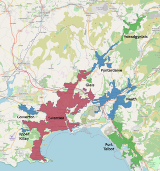
The Swansea Urban Area or Swansea Built-up Area is an area of land in south Wales, defined by the Office for National Statistics for population monitoring purposes. It is an urban conurbation and is not coterminous with the City and County of Swansea. It consists of the urban area centred on Swansea city centre; the Swansea Valley including Clydach, Ystradgynlais and Pontardawe; and includes Neath and Port Talbot which are outside the county boundaries, but excludes the urban area of Gorseinon within the county boundaries.

<span class="mw-page-title-main">Stan Moorhouse</span> GB & England international rugby league footballer

Stanley Moorhouse was an English professional rugby league footballer who played in the 1900s, 1910s and 1920s. He played at representative level for Great Britain and England, and at club level for Huddersfield and Bradford Northern as a wing, i.e. number 2 or 5.

References

  1. 1 2 "2011 Census - Built-up areas". ONS . Retrieved 5 July 2013.
  2. "West Yorkshire BUA". statistics.data.gov.uk. ONS. Retrieved 24 October 2017.
  3. "Census 2001: Key Statistics for urban areas in England and Wales" (PDF). Archived from the original on 5 January 2016.{{cite web}}: CS1 maint: bot: original URL status unknown (link)
  4. "1991 Urban Areas". Archived from the original on 18 July 2006.{{cite web}}: CS1 maint: bot: original URL status unknown (link)
  5. Census 1981 : key statistics for urban areas : the North, cities and towns. Great Britain. Office of Population Censuses and Surveys. London: H.M.S.O. 1984. ISBN   0116910615. OCLC   10979725.{{cite book}}: CS1 maint: others (link)

53°43′N1°38′W / 53.717°N 1.633°W / 53.717; -1.633